<home # start here # guides # builds # services # shop # about # categories>

Far to the northeast of Moscow, beyond Siberia’s great forests, beyond Lake Baikal, and deep inside the Russian Far East, the Anadyr River cuts through the landscape of Chukotka. Here the river is enormous compared with the small streams that feed it. It freezes for much of the year. Winters are severe. Summers are short. The surrounding landscape changes between forest, forest-tundra, open tundra, wetlands, mountains and river valleys. Yet, at the meeting of the Belaya and Anadyr Rivers, people lived, hunted, fished and travelled thousands of years ago.
Their archaeological remains became known as the Ust-Belskaya culture. The type-site is the Ust-Belaya settlement and cemetery. It is one of the most interesting archaeological windows into the Late Neolithic and Early Metal Age of inland Chukotka. And, its story is rather different from the familiar Neolithic story of the Fertile Crescent. There are no wheat fields here. No barley fields. No orchards of apples or pears. No herds of sheep or goats. Instead, survival depended upon wild reindeer, fish, birds, gathered plants, rivers, stone, bone, antler and an intimate knowledge of an extreme northern landscape [1–4].
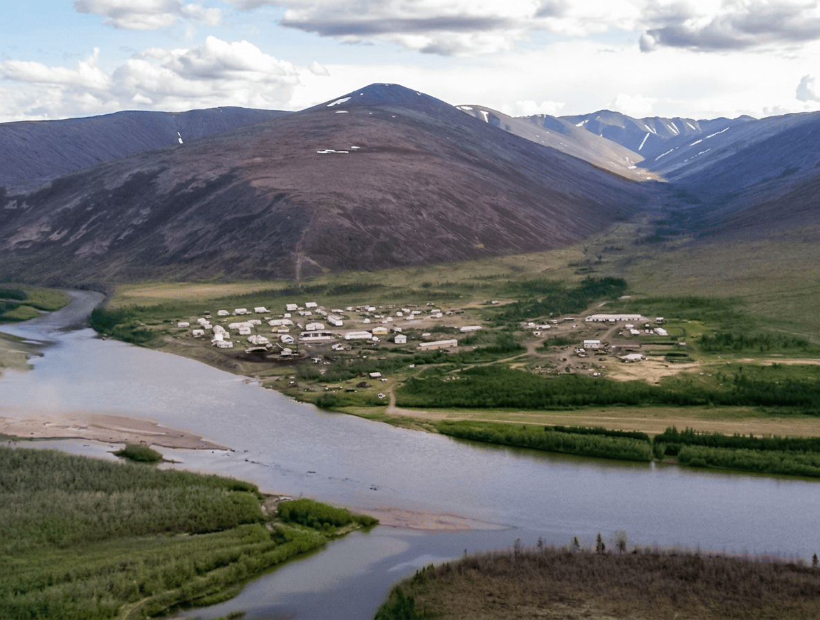
Ust-Belaya is in the Anadyrsky District of Chukotka Autonomous Okrug, northeastern Russia
The archaeological site is associated with the modern settlement of Ust-Belaya, at approximately: 65.50° N, 173.28° E. [5] The village stands at the confluence of the Belaya River and the Anadyr River. The Belaya approaches from the west/southwest and joins the Anadyr in the interior of Chukotka. This is a very different geographical world from European Russia.
It is also very far from Lake Baikal. Using the modern coordinates, Ust-Belaya is approximately 3,850–3,900 km from the central/southern Lake Baikal region in a straight line. By practical ancient travel routes, the distance would have been considerably greater.
The Aral Sea is roughly 6,500 km away in a straight line.
This distinction matters because there are several archaeological traditions called Ust-Belaya/Ust-Belskaya, and the similarly named Ust-Belaya on the Angara really is associated with the Baikal region. The Chukotka site is not.
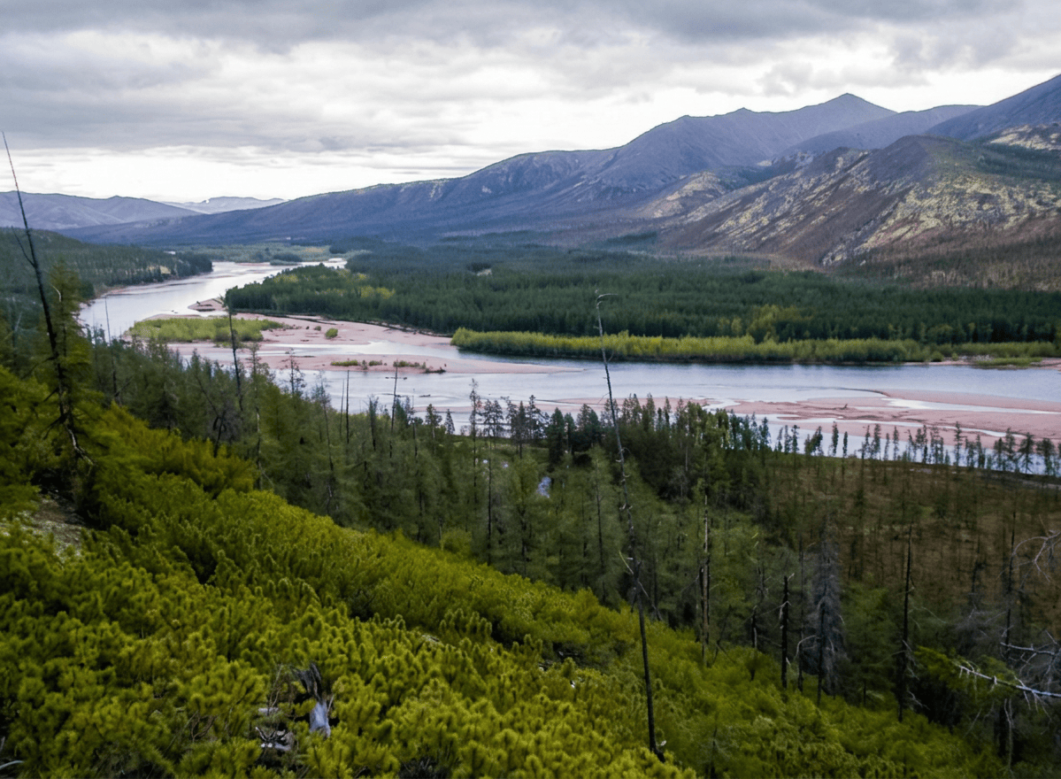
Ust-Belaya lies in the interior Anadyr River basin. Northeastern Siberia, Russian Far East and Chukotka
The area is part of a broad ecological transition between forest-tundra, tundra, river floodplain, wetlands, mountains and open landscapes. The Ust-Belskaya cultural tradition is specifically associated with the forest-tundra of Chukotka [1].
The modern village lies on the northern slope of Mount Gynryretyk, a local mountain whose Chukchi name is traditionally interpreted as meaning something like “the Guardian” [5]
More broadly, the Ust-Belaya region is surrounded by the mountain systems of the interior Chukotka landscape. The Ust-Belaya Mountains and mountainous area, form part of the wider Koryak-Chukotka geological landscape. The Belaya River itself originates farther north in the Anadyr Mountains and passes through mountainous country before entering the lower, broader Anadyr basin [6]. So the archaeological setting was not flat Arctic tundra. It was a meeting zone of mountains, river valleys, forest-tundra and open tundra.
Was this an extreme environment? Yes but with an important qualifications
Ust-Belaya was an extreme environment by agricultural standards, but it was not the same thing as a high-Arctic coastal settlement. It was an interior subarctic/forest-tundra environment. The modern climate is continental and subarctic, with long, very cold winters and short summers [5]. The Belaya and its tributaries are frozen for roughly eight to nine months of the year [6]. That tells us something important about the ancient economy. The people had to organize their lives around a landscape in which: water was abundant—but seasonally locked in ice. The growing season was short. Plant cultivation was difficult. Large portions of the year were dominated by snow and frozen rivers. Yet summer could produce a tremendous pulse of biological productivity. That seasonal contrast was the key to survival.
The great highway: the Anadyr River
The Anadyr is approximately 1,150 km long and drains a huge portion of Chukotka [7]. Ust-Belaya is positioned where the Belaya enters this major river system. That is an extraordinary location for hunter-gatherers. A river provides drinking water, fish, travel, seasonal animal crossings, access to different ecological zones, transportation corridors and communication with neighbouring communities. And, the Ust-Belskaya sites were not randomly scattered. Archaeologists have noted that settlements were often positioned near seasonal reindeer crossings of rivers [1]. That is an extraordinary example of landscape planning. Instead of building a road to the food source, the people positioned themselves beside the animals’ road.
What did the settlement look like?
This is where we have to distinguish between the Ust-Belaya cemetery and the wider Ust-Belskaya settlement tradition. The principal Ust-Belaya archaeological complex includes habitation sites, a cemetery, multiple cultural deposits, stone and bone artefacts and pottery. The type-site itself was investigated beginning in the 1950s. Nikolai Nikolaevich Dikov discovered the archaeological complex in 1956 and subsequently excavated the cemetery [2,3]. The cemetery eventually included 15 barrows and three pits containing human skeletal material and grave goods [2]. However, the published archaeological record does not provide a complete excavated Ust-Belaya house plan comparable with Çatalhöyük, Jericho or Çayönü. This is extremely important. We should not draw a neat rectangular house with four walls and a roof and label it “the Ust-Belaya house.” The evidence doesn’t justify that level of certainty.
Did they have subterranean houses?
Possibly in the wider regional tradition but not securely demonstrated at the Ust-Belaya cemetery itself.
Archaeological investigations elsewhere in the broader Chukotkan region documented semi-subterranean dwellings. For example, an archaeological report from Dikov’s work records a settlement at Osinovaya Spit with a semi-subterranean dwelling and hearths [8]. That is valuable comparative evidence. But it should not automatically be transferred to the Ust-Belaya cemetery. For a responsible reconstruction of the Ust-Belaya site: semi-subterranean houses should be presented as a plausible regional construction, not as a securely excavated Ust-Belaya building. A lightweight structure using poles, hides, bark and other organic materials is plausible for mobile or seasonal occupations, but this remains a reconstruction hypothesis, rather than a demonstrated Ust-Belaya building.
Timber certainly existed in the region and could have been extremely valuable, but preservation and excavation have not produced the sort of structural plan that would let us reconstruct a conventional timber-frame house with confidence.
Why might semi-subterranean architecture make sense?
This is where architecture and climate come together. A partially buried dwelling has several advantages in a cold continental environment: less exposed wall area, reduced wind exposure, greater thermal stability, smaller fuel requirement and better winter survival. This is exactly the sort of architectural strategy that becomes attractive in a region where winters are long and severe. But again: The archaeological evidence demonstrates the regional use of semi-subterranean architecture; it does not establish that every Ust-Belaya household lived in one.
Hearths
Fire was essential. The archaeological record of northeastern Siberian settlements contains hearths and fire installations, and Ust-Belskaya habitation sites are part of this broader technological system [8]. A hearth provided heat, cooking, drying, lighting, smoke for preserving food and working light for bone and stone manufacture. In an environment where winter temperatures can become brutally cold, the hearth was not a decorative feature. It was the centre of the building’s survival system.
The most clearly identifiable special architecture is the cemetery itself
The Ust-Belaya cemetery contained numerous burial mounds and pits [2]. This was not simply a place where somebody happened to be buried. It became a persistent social landmark. The cemetery was positioned on a prominent part of the landscape, and the burial mounds created visible modifications of the terrain. That is architecture. Not architecture of walls and roofs but architecture of: earth, stone, bodies, objects and memory.
The burial mounds
The cemetery included approximately 15 barrows, along with three additional pits [2]. Mound 15 has been especially important for modern research. Its excavated area covered approximately 130 m², and archaeologists identified seven concentrations of finds occupying up to about 45 m² [2]. That is a substantial archaeological area. The mound was not simply a hole in the ground. It was a deliberately constructed place.
Cremation and unusual burial practices
Human remains from the Ust-Belaya cemetery include evidence interpreted as partial cremation/burning in at least some contexts [3,9]. This is particularly interesting because the Ust-Belskaya mortuary tradition does not appear to have followed a single universal burial procedure. Instead, there was variation in treatment of the dead. That suggests ritual flexibility. Fire could become part of the mortuary process.
For the Ust-Belaya cemetery of Chukotka, we would not claim a widespread ochre-burial tradition without qualification
The strongest securely documented characteristics are: burial mounds, human remains, partial burning/cremation in some contexts, extensive grave goods, bone and antler implements, stone tools, pottery and ornaments. So for a reconstruction, ochre should not be made a dominant visual feature as it might be at some Early Neolithic Siberian cemeteries.
What did they eat?
The answer is remarkably different from the agricultural Neolithic of the Near East. The Ust-Belskaya economy was based primarily upon Reindeer hunting. Plus: Fishing, Bird hunting/trapping and Plant gathering. Modern syntheses specifically identify reindeer hunting, fishing, bird trapping and gathering as the principal subsistence activities [1]. This was a highly adapted hunter-gatherer economy.
Reindeer were central
Wild reindeer were probably the most important terrestrial resource. This makes perfect sense geographically. Reindeer could provide: meat, fat, hide, sinew, antler, bone, marrow, tools and clothing material. One animal could therefore supply a remarkably large proportion of a technological system. And, the Ust-Belskaya settlements were strategically positioned around seasonal river crossings of reindeer [1]. That is almost an architectural diagram of the economy: reindeer migration, river crossing, camp, hunting, butchering, hide/bone/antler processing and food + clothing + tools
The environment is simply not analogous to the agricultural landscapes of Anatolia, Mesopotamia or the southern Caucasus
The term Neolithic must therefore be used carefully. In northeastern Eurasia, “Neolithic” does not automatically mean farming, villages and domesticated animals. It can mean pottery, ground stone, new technologies and changing hunter-gatherer economies.
What plants did they eat?
Wild plants were gathered. The archaeological literature identifies gathering as part of the Ust-Belskaya economy [1]. Likely resources in the broader Anadyr environment included berries, edible roots, leaves, seeds and other seasonal plant foods. However, it is important not to turn a list of modern Chukotkan plants into a claimed archaeological menu. Unless a particular plant is demonstrated archaeobotanically at Ust-Belaya, it should remain a regional ecological possibility, not a confirmed food.
Fish
Fish were an important part of the economy. The Ust-Belskaya people lived beside one of northeastern Asia’s great river systems. Fishing complemented reindeer hunting and allowed people to exploit the enormous seasonal productivity of the Anadyr drainage [1].
The combination was extremely sensible. Reindeer supplied large quantities of meat and materials. Fish provided a different seasonal resource. Birds added another. Gathered plants supplied still more. This was risk management through biodiversity.
Birds
Bird hunting and trapping were part of the Ust-Belskaya subsistence system [1]. The river valleys and wetlands of the Anadyr region provide excellent seasonal bird habitat. Waterfowl could therefore become an important spring and summer resource. This also explains why a river junction was valuable. A river is not simply a source of fish. It creates an entire ecosystem.
What about hares and small game?
Small game was certainly available in the regional ecosystem, but the evidence for individual species at the Ust-Belaya cemetery is less secure than the broad evidence for reindeer, fishing and birds.
Dogs are much more complicated
Dogs were present in northeastern Siberian prehistoric societies, but the evidence specifically associated with the Ust-Belaya cemetery is not sufficient to make dog husbandry a defining feature of the culture.
The really important domesticated-animal distinction here is that the economy was not based upon herding domesticated livestock.
Stone technology
The Ust-Belskaya stone inventory includes a broad range of tools. These include: cores, flakes, knife-like blades, projectile points, knives, scrapers, burins, perforators, axes and adzes. The stone technology is broadly related to other northeastern Siberian traditions, especially the North-Chukotkan material culture [1]. This is a sophisticated toolkit. It allowed people to manufacture and maintain hunting equipment, fishing equipment, woodworking tools, hide-processing tools and bone-working equipment.
Flint and chert
Chert and other knappable siliceous rocks were important. The people did not have to import every tool. Local and regional stone sources could supply much of the ordinary technological toolkit. This is another advantage of river-based settlement. Rivers expose: pebbles, cobbles, gravel and workable stone. The river can become a geological shopping aisle.
Nephrite is interesting
The Ust-Belaya assemblage includes white nephrite rings/ornaments and nephrite tools are part of the wider technological sphere with which the Ust-Belskaya material is compared [11]. Nephrite is exceptionally tough. That makes it excellent for: axes, adzes, polished toolsand
ornaments. Its presence is also archaeologically valuable because nephrite sources are geographically restricted. The movement of nephrite therefore provides clues about contacts between distant communities.
Did they trade with China?
There is evidence for cultural interaction across northeastern Asia, but we should be cautious about saying: “Ust-Belaya traded directly with China.” The archaeological evidence does not establish a direct merchant route to China. Instead, there were networks of technological and cultural interaction extending across Chukotka, Yakutia, the Amur region, Transbaikalia, the Pacific coast and Alaska. Some technological forms have parallels across these enormous distances [1,10,11]. That is better described as a network of interaction than a single trade route.
What about Alaska?
Here things become much more interesting. Chukotka faces Alaska across the Bering region. Researchers have identified technological parallels between Ust-Belskaya material and cultures of the wider Pacific North, including similarities in bone technology [2,10].
Zelenskaya’s study specifically identifies relationships with: Koryak, Itelmen, Aleut and Eskimo traditions. The strongest morphological similarities in the analysed bone assemblage were with Eskimo material [2]. That does not mean Ust-Belaya people were “Eskimos.” It means that technological ideas and forms circulated across northeastern Asia and the Beringian world.
The toggling harpoon
One of the most famous Ust-Belskaya objects is the toggling harpoon point. This is extremely interesting because toggling harpoons are particularly effective for large aquatic animals. The object has been interpreted as evidence of interaction with the coastal hunting world and possibly marine-mammal hunting [1,2]. But there is an important caution: Ust-Belaya itself is inland. It is not a coastal walrus-hunting settlement.
Therefore, a toggling harpoon in the cemetery should not automatically be interpreted as proof that the whole community was a maritime hunting society. Instead, it demonstrates contact with technologies associated with the wider Beringian/Pacific hunting world.
Walrus?
A toggling harpoon point has traditionally been interpreted as an indication of walrus hunting. However, because Ust-Belaya lies deep inland on the Anadyr system, the safest interpretation is: marine-hunting technology had reached the inland community or individuals associated with the cemetery. Whether the specific individual personally hunted walrus is much harder to prove. That distinction is important.
Bronze
This is one of the really unusual aspects of Ust-Belskaya archaeology. Although most of the technological system remained stone, bone and antler based, bronze objects occur. Researchers identify bronze burins/cutting tools as a distinctive feature of the Ust-Belskaya tradition [1]. This is why some archaeologists classify the culture as belonging partly to the Early Metal Age / Bronze Age, rather than treating it as purely Neolithic. The technological transition was therefore not: stone suddenly disappears. It was stone, bone, antler, pottery and limited metal. That is a much more interesting picture.
Where did the bronze come from?
This is one of the most fascinating questions. Research summarized in The Stone Age of Chukotka suggests that bronze from the Ust-Belaya cemetery had a South Siberian source [12]. It means that metal was probably entering Chukotka through long-distance interaction networks. The exact route remains uncertain. Possible intermediary zones included parts of: Yakutia, Transbaikalia and southern Siberia. So Ust-Belaya gives us evidence for an enormous technological communication system.
Ust-Belskaya pottery is distinctive
The ceramics include round-bottomed vessels with characteristic decoration. One particularly notable feature is ribbed decoration / impressions, which helps distinguish the Ust-Belskaya ceramic tradition [1,12].
The vessels were practical technologies. They could be used for: boiling, cooking, processing food and storing material. And, in a hunter-gatherer society, pottery could dramatically expand the ability to process aquatic and terrestrial foods.
Textiles and pottery
Some northeastern Siberian ceramic traditions show impressions suggesting that vessels were formed or decorated using textile-like materials.
Pottery technology provides evidence of a sophisticated ceramic tradition, but we should avoid claiming that every vessel was literally formed over a woven basket unless the individual vessel provides that evidence. Nevertheless, the pottery demonstrates something important: ceramic technology had reached an inland hunter-gatherer society living in a very cold environment.
Precious stones and ornaments
The cemetery contained ornaments made from materials including: shell, nephrite, animal teeth and bone. A particularly interesting discovery was a concentration of small shell beads, interpreted as having once decorated clothing or headgear [13]. These are tiny objects. But they tell us something enormous. People cared about appearance, identity, clothing and status. There was no gold but even in an extremely demanding environment, it was demonstrated personal ornamentation mattered.
Figurines and animal art
The Ust-Belaya assemblage includes decorated bone and antler objects. Some have zoomorphic or anthropomorphic characteristics. The artistic tradition belongs to the larger symbolic world of northeastern Siberia, where animals were represented through portable objects and ornament [3,14]. This is important because the same animals that supplied food and raw material could also become symbols, identities, stories and ritual objects.
Weapons
The archaeological assemblage includes arrowheads, spear/projectile points, harpoon elements, burins, knives and axes/adzes. The bow-and-arrow system is particularly important. A bone terminal or end fitting associated with a bow has been reported from Ust-Belaya II, alongside stone blades and pottery [3]. The hunting technology was therefore sophisticated enough to exploit highly mobile prey.
What did architecture mean here?
We can divide its architecture into three layers. Layer 1 — Shelter architecture. Probably lightweight structures, with regional evidence for semi-subterranean dwellings.
Layer 2 — Resource architecture. Camps positioned near: rivers, fish, reindeer crossings, forests and wetlands.
Layer 3 — Mortuary architecture. The cemetery transformed a hilltop into a place of: burial, memory, ritual and social identity. The third layer is exceptionally well documented.
The cemetery was a machine for remembering
Imagine living in a mobile society. Your camp may move. The river changes. The reindeer migrate. The hunting grounds change. The weather changes. But the cemetery remains. A burial mound can become a permanent landmark. It says: We were here. And, perhaps These people belonged here. The cemetery therefore anchored a mobile society to a particular landscape. That may be the most important architectural idea at Ust-Belaya.
Why live beside a river?
Because the river was simultaneously: road, refrigerator, fishing ground, animal crossing, drinking water and communication corridor. The Anadyr connected enormous portions of interior Chukotka. A settlement here could exploit several ecological zones without requiring permanent agricultural fields. This is architecture as resource geography.
Was it a water-based economy?
Partly—but not primarily a maritime economy. Fishing was important. The river was essential. But the Ust-Belskaya economy was primarily an inland hunting economy, especially focused on reindeer, supplemented by fishing, bird trapping and gathering [1,2]. That distinction separates Ust-Belaya from the later great maritime hunting societies of the Bering Sea.
Did they build boats?
There is no excavated Ust-Belaya boat that allows us to reconstruct a hull with confidence. Nor is there a preserved boat-building workshop. However, river travel would have been highly advantageous. The Anadyr is navigable for substantial distances today, and its tributaries formed natural transportation corridors [7]. The archaeological evidence therefore strongly supports a riverine way of life, but not a particular boat design. A reconstruction of a skin boat, log boat or dugout should therefore be labelled ‘experimental/regional reconstruction—not excavated fact.’
The most interesting architecture ‘seasonal’
The Ust-Belskaya settlement pattern suggests people were strategically following the landscape. Sites were located at seasonal reindeer crossings. That means architecture may have been seasonally assembled and dismantled. This makes the archaeological record very different from Jericho or Çatalhöyük. At Jericho, the architecture stays. At Ust-Belaya, the people and technology move with the landscape. The landscape itself becomes the infrastructure.
Climate change
Climate was never static. The Late Holocene landscape of northeastern Siberia experienced changes in: vegetation, temperature, moisture, river dynamics and animal distributions. The broader archaeological literature on Arctic and subarctic Siberia demonstrates that human populations repeatedly reorganized their subsistence strategies in response to changing environmental conditions. [15]
For Ust-Belaya, however, we should avoid claiming that a single documented climate event caused the site to be abandoned. The archaeological evidence is not strong enough to support such a simple explanation.
So why was it abandoned? There is no securely demonstrated single “abandonment event”
The Ust-Belskaya tradition covered a broad area and consisted of multiple settlements and camps. People were mobile. Individual camps could disappear because reindeer migration changed, fishing conditions changed, a local resource became less productive, river channels shifted, social networks changed and new camps became more advantageous. This is very different from the abandonment of a permanent farming town. We should therefore speak of changes in site use and settlement patterns, rather than imagining one catastrophic day when everyone packed up.
The Ust-Belskaya tradition eventually became part of a much larger sequence of cultural transformations across northeastern Siberia
Researchers debate how precisely it relates to: Ymyyakhtakh traditions, North-Chukotkan culture, later Beringian cultures and ancestral populations of later Chukchi and other northeastern peoples. Some scholars see Ust-Belskaya as an eastern Chukotkan variant of the Ymyyakhtakh tradition; others emphasize local development with incoming technological influences [1].
The important point is: there was no simple replacement of one “race” by another. There was interaction.
Connections with the Eskimo world
The similarities between some Ust-Belaya bone tools and later/nearby Eskimo technological traditions are particularly intriguing. Zelenskaya’s detailed analysis identified morphological relationships with: Koryak, Itelmen, Aleut and Eskimo material. The strongest similarities in the analysed bone assemblage were with Eskimo examples [2]. This suggests that the inland and coastal worlds were not isolated. Technology could move inland. Ideas could move inland. People could move inland.
Who discovered and researched Ust-Belaya?
The central figure is Nikolai Nikolaevich Dikov (1925–1996). Dikov was one of the great pioneers of archaeology in northeastern Siberia. He worked extensively across: Chukotkam, Kamchatka, Kolyma and the Arctic Far East.
He discovered the Ust-Belaya archaeological complex in 1956 and excavated the cemetery during subsequent field seasons [2,3]. His work was foundational to the definition of the Ust-Belskaya culture.
Modern researchers
Later research has included scholars associated with the North-East Interdisciplinary Scientific Research Institute of the Far Eastern Branch of the Russian Academy of Sciences, including Alisa Yuryevna Zelenskaya.
Zelenskaya’s work on the bone artefacts is especially important because earlier publications of the cemetery did not provide a complete morphometric and statistical treatment of its bone inventory [2].
Modern scholarship also places Ust-Belaya into the wider archaeological history of northeastern Siberia, particularly through researchers such as: Vladimir V. Pitulko, Pavel S. Grebenyuk, Alexander Yu. Fedorchenko, Viktor M. Dyakonov, Alexander I. Lebedintsev and Boris A. Malyarchuk. Their work connects archaeology, chronology, technology, population history and cultural interaction [1,10,15].
Something particularly special: the site connects inland and coastal worlds
Perhaps the most exciting thing about Ust-Belaya is its location. It is far inland. Yet its artefacts contain technological connections to the Pacific/Beringian coastal world. A toggling harpoon appears. Bone-working traditions show similarities with coastal cultures.
Pottery and stone technology connect Ust-Belaya with wider northeastern Siberia.
Bronze appears from southern sources.
Nephrite (jade) and shell ornaments occur.
The site therefore sits at the intersection of several worlds: SOUTH. Yakutia, Transbaikalia and southern Siberia;
EAST. Beringia, Alaska;
NORTH. Arctic Chukotka; and,
SOUTHWEST. Koryak and Kamchatka regions.
Ust-Belaya was not an isolated village at the “end of the world.” It was part of a very large communication network.
Ust-Belaya as an architectural system
MOUNTAINS: stone, animals and water sources
FOREST-TUNDRA: fuel, timber, berries/plants and terrestrial game
RIVERS: fish, transport and seasonal crossings
REINDEER: meat, hides, antler, bone and sinew
CAMP: shelter, hearth, tool production and food processing
CEMETERY: graves, mound, objects, ritual and memory
This is architecture without monumental masonry.
The Ust-Belaya “house”
If you are preparing an illustration, do not draw a mud-brick house. Instead show a small, highly insulated, partly sunken or lightweight seasonal structure. Label it clearly as a regional reconstruction.
A plausible illustration could include: shallow/partly sunken floor, timber or pole framework, hide/bark/organic covering, central or offset hearth, low sleeping/seating platforms, drying racks, fishing equipment, bow and arrows, reindeer-processing equipment, pottery and bone and antler tools.
But the caption should say: “Experimental reconstruction based on regional Ust-Belskaya and northeastern Siberian evidence; no complete house plan is known from the Ust-Belaya cemetery.”
The people of Ust-Belaya did not conquer their environment. They read it
They knew: where reindeer crossed, when fish arrived, where birds gathered, where stone could be obtained, where plants could be collected, where a camp could shelter from wind, where a river could be crossed, where ancestors were buried. Their architecture was therefore not just the building. It was the relationship between the building and the landscape.
Another big lesson
Ust-Belaya should change how we define the Neolithic. There is a temptation to think that the Neolithic was farming, villages, houses and towns. Ust-Belaya shows another path. A society can have: pottery, sophisticated stone tools, bone technology, antler technology, bronze, ornaments, complex hunting equipment, fishing, ritual burial and long-distance cultural connections. Without becoming an agricultural society. The Neolithic was not one invention. It was a collection of different technological and social experiments.
If there is one thing to put in a large box beside the article, it would be this
Ust-Belaya was not a failed agricultural settlement. It was a successful hunter-fisher society adapted to one of the world’s most demanding landscapes. Its people did not need wheat. They had reindeer. They did not need orchards. They had seasonal wild foods. They did not need roads. They had rivers. They did not need masonry monuments. They had burial mounds. They did not need a giant city. They had a landscape that functioned as their infrastructure. And, perhaps most importantly: their technology connected the interior of Chukotka to a much larger world extending toward Yakutia, southern Siberia, Kamchatka and the Beringian/Pacific sphere. That is what makes Ust-Belaya such a powerful case study in neolithic architecture and the architecture of survival.

References: [1] Grebenyuk, P. S., Fedorchenko, A. Yu., Dyakonov, V. M., Lebedintsev, A. I., & Malyarchuk, B. A. (2022). Ancient Cultures and Migrations in Northeastern Siberia. In V. N. Bocharnikov & A. N. Steblyanskaya (Eds.), Humans in the Siberian Landscapes, pp. 89–133. Springer.
[2] Zelenskaya, A. Yu. (2017). The bone artifacts of the Ust-Belaya burial ground, and some issues of cultural interaction in the Neolithic on the North of the Far East. Archaeology, Anthropology and Ethnography of Eurasia / Вестник археологии, антропологии и этнографии, 4(39), 5–14. DOI: 10.20874/2071-0437-2017-39-4-005-014.
[3] Dikov, N. N. (1977/1979). Major publications on the archaeology of Chukotka, including the Ust-Belaya cemetery. Dikov’s excavations formed the original basis for defining the Ust-Belskaya culture. His fieldwork is summarized in later archaeological scholarship and the 2025 biographical bibliography.
[4] Pitulko, V. V. (2003/2010). Research on the Stone Age and environmental adaptations of northeastern Siberia, including the chronological and cultural position of the Ust-Belaya tradition. See also The Stone Age of Chukotka, Northeastern Siberia: New Materials.
[5] Ust-Belaya geographical information: location at the confluence of the Anadyr and Belaya Rivers, northern slope of Mount Gynryretyk, and modern climate.
[6] Geological and geographical research on the Ust’-Belaya Mountains and Belaya River system. The Belaya passes through the Anadyr Highlands/Pekulney region before reaching the Anadyr basin.
[7] Geographical information on the Anadyr River: approximately 1,150 km long, draining much of Chukotka and forming a major interior transportation corridor.
[8] Dikov’s archaeological field records and later summaries document regional settlement evidence including hearths and a semi-subterranean dwelling at Osinovaya Spit, as well as other Chukotkan settlement features.
[9] Research on Ust-Belaya cemetery contexts records human remains with partial traces of burning/cremation and extensive mortuary inventories.
[10] Grebenyuk, P. S., et al. (2022), Ancient Cultures and Migrations in Northeastern Siberia. This provides the modern comparative framework for Ust-Belskaya relationships with North-Chukotkan, Ymyyakhtakh and wider northeastern Siberian traditions.
[11] Archaeological syntheses of northeastern Siberia note Ust-Belaya’s characteristic assemblage of stone tools, bone/antler technology, nephrite ornaments and technological similarities extending toward Yakutia and other regions.
[12] The Stone Age of Chukotka, Northeastern Siberia: New Materials. Research summarized there indicates that bronze from the Ust-Belaya cemetery may have a South Siberian source, demonstrating long-distance movement of metal technology into northeastern Siberia.
[13] Archaeological syntheses of Siberian prehistoric societies describe shell beads and ornaments from Ust-Belaya, including concentrations interpreted as clothing/headgear decoration.
[14] Zelenskaya, A. Yu. (2019). Research on ornamentation of bone implements from Ust-Belaya mound 15, addressing the decorative and possible symbolic significance of the artefacts.
[15] Pitul’ko, V. V. (1999). Ancient humans in Eurasian Arctic ecosystems: Environmental dynamics and changing subsistence. World Archaeology, 30(3), 421–436. This is useful for the broader question of how Arctic and subarctic hunter-gatherers adapted to environmental change.
[16] Ponkratova, I. Yu. (compiler). (2025). Nikolai Nikolaevich Dikov: On the 100th anniversary of his birth—Bio-bibliographic index. North-Eastern State University, Magadan. This is particularly useful for tracing Dikov’s expeditions, publications and long-term contribution to Chukotkan archaeology.
Leave a Reply