<home # start here # guides # builds # services # shop # about # categories>
Khuzistan, southwestern Iran — approximately 6200–5900 BCE
Tepe Tula’i is one of the strangest—and most useful—Neolithic sites in Iran. It was not a conventional mud-brick farming village. Instead, the evidence points toward a camp occupied by people moving livestock seasonally between the lowlands and the Zagros. That makes Tula’i important for a different reason from sites such as Sialk or Sang-e Chakhmaq: its architecture may represent mobility.
Rather than asking, “How did Neolithic farmers build a permanent house?”, Tula’i asks: “What does Neolithic architecture look like when the builders intend to leave?” [1][2]
Recent analysis of the site’s stone tools has revived the debate over whether Tula’i was a truly mobile pastoral camp or a temporary outpost used by herders connected to permanent farming communities [3].
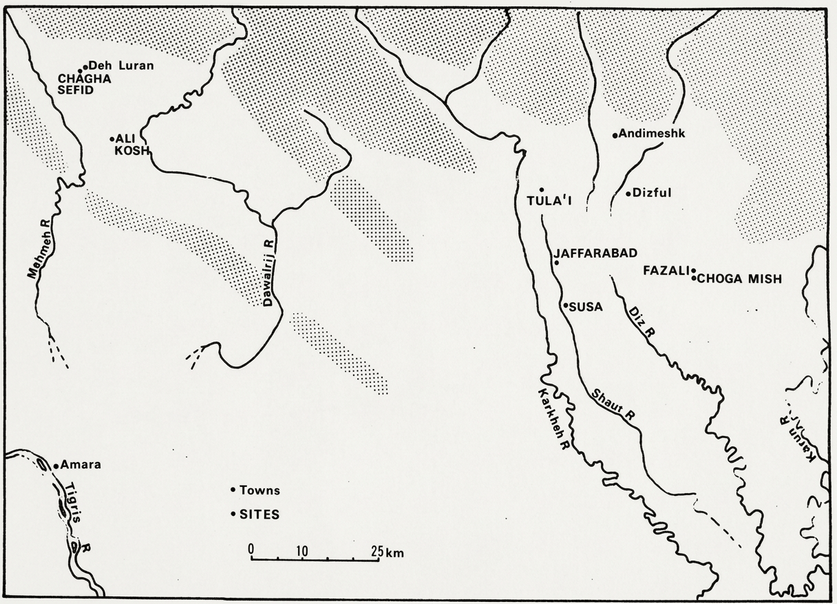
Where was Tula’i?
Tepe Tula’i was located in northwestern Khuzistan, approximately: 15 km south of Andimeshk. 17 km west of Dezful and about 4 km east of the Karkheh River. Roughly 4–6 km from the Shaur River and at approximately 110 m above sea level [1][3][4].
The coordinates published for the site are approximately 32°25′25.5″ N, 48°11′54.6″ E [3].
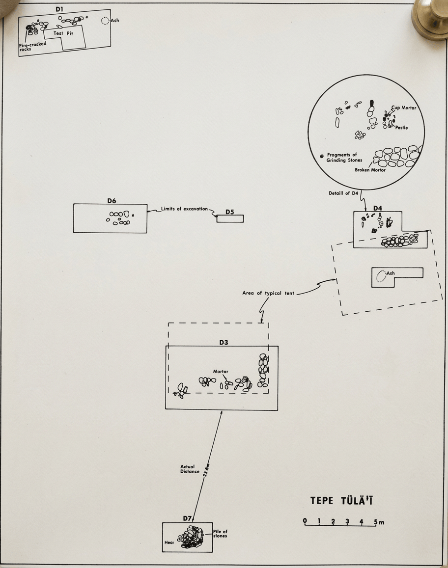
(plan of site)

The site itself has unfortunately been largely destroyed by modern agricultural levelling. Frank Hole discovered it in 1973 after prehistoric material appeared in a bulldozed canal bank. The surviving mound was about 60 m across and 1.5 m high [1][3].
Tula’i was instead associated with the Karkheh and Shaur river systems
The Karkheh is still a major river today. The Shaur also remains part of the modern southwestern Iranian drainage system. So Tula’i stood on the eastern edge of the Karkheh floodplain/piedmont zone, close enough to exploit several ecological environments but not directly on a great riverbank [4]. This is important: the site was close to water, but its inhabitants apparently did not build their settlement around intensive irrigated agriculture.
Zagros Mountains: right next door
This is genuinely a Zagros landscape. Tula’i lies in the piedmont zone where the lowlands of Khuzistan meet the Zagros. The mountains rise east and northeast of the site.
The archaeological interpretation suggests a possible seasonal route between the Khuzistan lowlands and summer pastures in the Zagros, potentially extending toward the Khoramabad/Luristan region [2][5]. That makes Tula’i a fascinating architectural midpoint: lowland farming communities, Tula’i pastoral camp and Zagros summer pastures. It may have been a place where people and animals moved through the landscape rather than a village intended to remain permanently occupied.
Lakes?
There was no major lake immediately beside Tula’i. But the landscape contained something almost as useful: marshes and seasonal wetlands. The faunal study reconstructed several ecological zones around the site: open sandy plains; seasonal and permanent marshes; riverine habitats; rocky hillsides; and high mountain environments [4]. Fish, aquatic turtles, freshwater mussels and water birds could therefore be obtained from the wetlands and rivers [4]. The landscape was considerably more biologically diverse than the dry appearance of modern Khuzistan might suggest.
What was the climate like?
This is one of the most interesting parts.
The broader Susiana/Khuzistan lowlands appear to have supported substantially wetter environments during the early Holocene. Evidence from nearby Chogha Bonut indicates that the region included wet grassland with marshy environments during the earlier Neolithic [3].
By the Tula’i period, around 6200–5900 BCE, the region was already experiencing the climatic transition toward greater aridity associated with the 6.2 ka climate event, although the exact local expression and timing remain debated [6].
The landscape therefore offered a powerful seasonal combination: winter/lowland grazing, spring growth and movement toward mountain pastures. That seasonal ecological gradient may be one reason pastoral mobility was so attractive.
Agriculture—or almost none?
This is where Tula’i becomes unusual. There is no convincing archaeological evidence that Tula’i itself was an agricultural settlement. Most importantly, excavators did not find the expected concentration of sickles or cereal-grinding equipment [3][7]. That is striking because contemporary permanent villages in Khuzistan cultivated cereals. So, while the people who used Tula’i may have belonged to farming communities, Tula’i itself appears to have been primarily a herding camp.
The wider Zagros landscape naturally provided wild plant foods
Frank Hole later suggested that pastoralists could have incorporated wild cereals and acorns into their economy [8].
Tula’i is not an early farming village that happens to have many goats. It appears to be a pastoral site where agriculture was largely absent from the immediate settlement. That makes its food economy unusually specialized.
Goats: the star of Tula’i
The animal bones tell a remarkable story. More than 8,500 animal bones were analyzed by Jane Wheeler Pires-Ferreira [4]. Of the identifiable meat-bearing remains, Capra/Ovis made up about 91%, but the overwhelming signal was actually goat. The study identified domestic goat remains, while finding no securely identified domestic sheep and no wild goat or wild sheep among the diagnostic caprine bones [4]. That is extraordinary.
The Tula’i economy was goat-heavy
The site appears to have been dominated by domestic goats, rather than the sheep-and-goat mixture common at many Neolithic villages. This fits the pastoral interpretation remarkably well. Goats were excellent animals for moving through rugged foothills and could tolerate relatively dry environments better than some other livestock.
Dogs?
Dog remains are reported from Tula’i, and later comparative work notes that dog was unusually abundant among the site’s non-caprine domestic animals [9]. That makes practical sense for a herding camp. Dogs could have helped with: guarding the camp; protecting livestock; controlling goats; and detecting predators.
Pigs?
There is evidence for wild boar (Sus scrofa) in the surrounding ecological zone, but pigs were not an important component of the Tula’i economy [4]. This is another contrast with some contemporary Neolithic communities farther north and west where pig hunting or early pig management was more significant.
And the wild animals?
Tula’i’s surrounding landscape was extraordinarily rich. The faunal study identifies: Gazelle, Wild ass/onager (Equus hemionus), Aurochs (Bos primigenius), Mesopotamian fallow deer (Dama mesopotamica), Wild boar, Wild goat and wild sheep in the surrounding mountain zone, Fox, Small mammals, Fish
Turtles, Freshwater mussels and Aquatic birds [4]
So the inhabitants were sitting in an ecological jackpot: goats on the hills, gazelle on the plain, aurochs, deer, fish, and wetlands + mountain game.
Aurochs?
Yes. Unlike some of the sites we’ve discussed, Tula’i’s regional faunal reconstruction specifically includes aurochs [4].
Ibex?
Wild goat (Capra aegagrus) occurred in the surrounding highland environment, although the diagnostic Tula’i caprine assemblage itself was dominated by domestic goats [4].
Deer?
Yes—Mesopotamian fallow deer. That is one of the more distinctive wild-food resources in this southern Zagros/Khuzistan setting [4].

The architecture: no mud-brick village
This is Tula’i’s architectural headline. There are no substantial mud-brick houses. Instead, excavators found stone alignments, ash deposits and low platforms [1].
Frank Hole compared these with the stone sleeping/storage platforms used by modern Lur pastoralists, particularly tent camps known ethnographically in the region [1][8]. The archaeological pattern suggests structures made primarily from: poles + reeds/brush + textiles or tent coverings + stone foundations/platforms. In other words: Tula’i may be Neolithic tent architecture. This is extremely important because archaeologists tend to recover permanent houses much more readily than mobile structures. A mud-brick house leaves walls. A tent leaves: a ring/line of stones, ash, activity areas, broken objects and animal bones. Tula’i is therefore a rare archaeological window into portable architecture.

A modern ethnographic clue
One of Frank Hole’s most interesting observations came from the Iranian workers helping excavate the site. They recognized the stone arrangements as similar to the platforms used by modern Lur pastoralists, who used stones to elevate bedding and stored possessions above the ground [1][8]. They also told Hole that suitable stones could be collected along the Karkheh River, roughly 4–6 km away [1]. This does not prove that Neolithic people copied modern Lur architecture. But it provides a remarkably useful ethnographic analogy: the same landscape still offered the same convenient construction material.
Was there a communal or ritual building?
No securely identified communal or ritual building has been found. There are no known monumental halls, temples, shrines or large communal structures comparable with Göbekli Tepe or Çayönü. That actually reinforces the pastoral interpretation. The architecture was apparently designed for small-scale domestic life and mobility, not for permanent communal construction.

Figurines: surprisingly many
Despite the lightweight architecture, Tula’i produced a surprisingly rich collection of figurines and small objects. Human figurines are among the most distinctive finds, and the assemblage includes both clay and stone examples [10]. This is important because figurines demonstrate that a mobile community could carry a substantial symbolic material culture. The absence of a permanent house did not mean an absence of art.
Game pieces?
There is no convincing evidence for a formal board-game assemblage at Tula’i. The site’s portable objects are instead dominated by: figurines; spindle whorls; ceramics; flint tools; ground stone; bone tools; and ornaments [3][10].
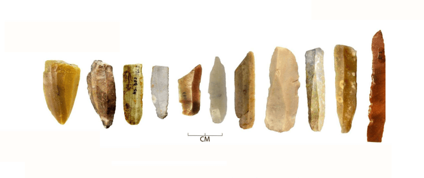
Weapons
The lithic assemblage includes cutting and projectile-related stone tools, but Tula’i is not famous for an exceptional weapon cache. The more interesting technological story is the ordinary toolkit of people who had to maintain themselves and their animals while moving: flint blades, scrapers, projectile tools, ground stone and bone tools. Recent lithic research has found that the stone-tool assemblage is substantial enough to provide new information about how mobile groups provisioned themselves and maintained their tools [3].
Flint: local and practical
Flint/chert was an important local technology. The 2025 lithic study is particularly useful because it examines core reduction, tool manufacture and provisioning strategies rather than simply listing artifacts [3]. This supports the idea that Tula’i was not merely a place where finished tools arrived from elsewhere. People were maintaining their own stone technology.
Obsidian?
There is no strong published evidence that obsidian was an important component of the Tula’i assemblage. Unlike some Zagros sites where chemically sourced Anatolian obsidian is a major clue to long-distance exchange, Tula’i’s lithic signature is dominated by locally available stone resources. That fits its character as a pastoral camp better than a major exchange center.
Bitumen: a remarkable regional technology
There is, however, another unusual material connection: bitumen. Bituminous material was recovered at Tula’i, and molecular analysis demonstrated that bitumen associated with Neolithic pottery at southwestern Iranian sites could be traced to geological sources in the Susa/Deh Luran region [11]. So even this apparently remote pastoral camp participated in a technological landscape where naturally occurring bitumen was available and used.
Pottery: yes—definitely Neolithic, but not Pre-Pottery
Tula’i is not a Pre-Pottery Neolithic site. It belongs to the early Ceramic Neolithic. Its pottery was sufficiently distinctive to allow Hole to correlate the occupation with the late Mohammad Jaffar–early Sefid phases of the Deh Luran sequence, approximately 6200–5900 BCE [1][4]. The pottery includes: plain wares;
painted wares; early geometric decoration; and ceramics comparable to those from Chogha Bonut, Chogha Sefid and Deh Luran [3][7]. The ceramic connections are particularly interesting because they show that the pastoral camp was not culturally isolated from permanent farming communities.
Was Tula’i abandoned?
Probably better described as seasonally occupied and later abandoned, rather than as a permanently inhabited village that was repeatedly destroyed. The prehistoric occupation is currently dated to approximately: 6200–5900 BCE.
Frank Hole suggested the site may have been used over perhaps 200 years, while other interpretations emphasize shorter or seasonal episodes [3][8].
There is no evidence for a series of major Neolithic rebuilding phases like those at a tell such as Sialk. Then comes a remarkable gap. The area was later used in the Sasanian period, around the 3rd–4th centuries CE, roughly 6,000 years after the Neolithic occupation [1]. Thus: Neolithic pastoral camp, enormous chronological gap, Sasanian settlement/canals and modern agricultural development. The modern agricultural levelling that revealed Tula’i also destroyed much of it [1].
The great archaeological debate: nomads or village herders?
Frank Hole originally interpreted Tula’i as an early nomadic pastoral camp [1].
Jane Pires-Ferreira instead argued that the goats represented a village-based fallow herd—animals taken away from the permanent agricultural village to graze temporarily [4].
Reinhard Bernbeck later reassessed the evidence and argued that the archaeological pattern suggested a more complicated mobility system [8].
And a 2015 quantitative reanalysis argued for seasonally mobile families, rather than merely specialist male herders [9].
The newest lithic study, published in 2025, deliberately frames the problem as:
nomadic campsite vs. short-term pastoral outpost [3].
The strongest more scientifically defensible—statement is: Tula’i provides some of the earliest and best archaeological evidence for substantial seasonal pastoral mobility in southwestern Iran, although exactly who lived there and how independently they moved remains debated.
Why Tula’i is special
Tula’i’s most important “food” is not wheat. It is goat. Its most important “building” is not a mud-brick house. It is probably a tent. Its most important “trade” is not necessarily obsidian. It is the movement of people, animals, pottery, tools and knowledge between lowland villages and the Zagros. And, its most important architectural lesson is surprisingly modern: A building does not have to be permanent to be architecture.
Tula’i suggests that around 8,000 years ago, people could construct a carefully organized living environment from stones, poles, reeds and portable materials, establish hearths and activity areas, manage large goat herds, maintain tools, make pottery and figurines—and then move on. For a study of Neolithic architecture, that makes Tula’i a crucial counterpoint to Jericho, Çatalhöyük, Sialk or Sang-e Chakhmaq. Those sites teach us how people learned to stay. Tula’i may teach us how people learned to move.
References: [1] Hole, F. (1974). Tepe Tula’i: An early campsite in Khuzistan, Iran. Paléorient, 2(2), 219–242.
[2] Cribb, R. (1991/2009). Nomads in Archaeology. Cambridge University Press.
[3] Shafizadeh, S., Khakib, M., & Marwick, B. (2025). Between Nomads and Settlers: A Quantitative Analysis of Lithic Assemblages from Tula’i (Tuleii), Zagros, Iran. Journal of Field Archaeology.
[4] Wheeler Pires-Ferreira, J. (1975–1977). Tepe Tula’i: Faunal Remains from an Early Campsite in Khuzistan, Iran. Paléorient, 3, 275–280.
[5] Civgin, I. (2017). The birth of mobile pastoralism in the Central Zagros: from Tepe Tula’i (6200–5900 BCE) to Tuwah Koshkeh. Anthropology Journal, 34, 49–81.
[6] Kouchoukos, N., & Hole, F. / Miller, N. F. Research on Holocene environmental and agricultural change in Khuzistan and the Susiana Plain.
[7] Hole, F. (1977). Studies in the Archaeological History of the Deh Luran Plain: The Excavation of Chagha Sefid. University of Michigan Museum of Anthropology.
[8] Bernbeck, R. (1992). Migratory Patterns in Early Nomadism: A Reconsideration of Tepe Tula’i. Paléorient, 18(1), 77–88.
[9] Sutliff, D. J. (2015). On nomadic transhumance at Neolithic Tepe Tula’i, Iran: A re-analysis of findings. Journal of Archaeological Science: Reports.
[10] Furusato, S. Research on Neolithic human figurines of Tula’i and related Iranian sites.
[11] Gregg, M., Connan, J., et al. (2007). Molecular and isotopic identification of archaeological bitumen from Neolithic southwestern Iran. The study identified Tula’i bitumen and demonstrated regional geological sourcing.
Leave a Reply