<home # start here # guides # builds # services # shop # about # categories>
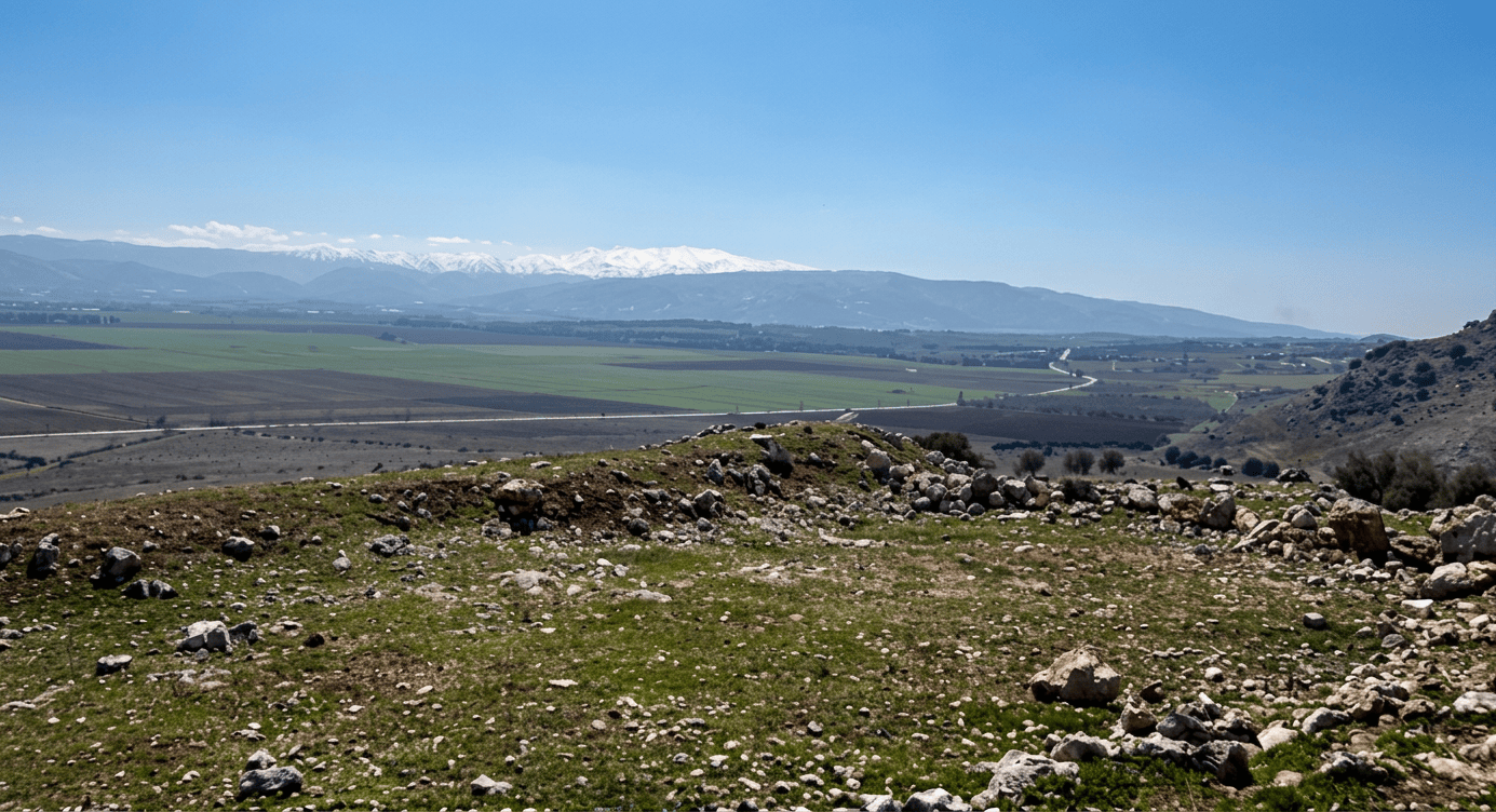
Neba’a Faour, also written Tell Neba’a Faour, Neba Faour, Nabaa Faour or Mashna’et el Faour, is one of the particularly interesting Neolithic sites of Lebanon because it preserves evidence for something between a plastered architectural technology and pottery: lime-plaster vessels known as White Ware or Vaisselle Blanche.
Unlike the Tahun ben Aissa locality, Neba’a Faour actually has evidence for settlement architecture: stone wall footings and plastered floors. It also produced sickle blades, grinding equipment, arrowheads, obsidian and White Ware vessels. The site gives us a much better opportunity to discuss how people lived, stored food and experimented with materials
But there is an important qualification. Much of the site was exposed by erosion and modern disturbance, and the archaeological record is not comparable to a large, fully excavated settlement such as Çatalhöyük. Much of what we know comes from surveys and exposed sections. [1–4]

Neba’a Faour lies in the eastern part of the Beqaa Valley, near the foot of an outlier of the Anti-Lebanon Mountains. Its coordinates are approximately: 33°46′56″ N, 35°58′05″ E
The archaeological tell is around 884–850 m above sea level, depending on the reference used. [5] It was situated near the ancient and modern route running between Beirut and Damascus, making its position particularly interesting from the perspective of movement through the Levant. Moore describes it as lying on the eastern side of the Beqaa, at the foot of an Anti-Lebanon outlier. [2,3]
The landscape presents Neba’a Faour as a settlement positioned between: the broad agricultural Beqaa plain; the Anti-Lebanon foothills; springs and streams descending from the mountains; routes toward Damascus and inland Syria; routes southward toward the Jordan Valley; and, beyond Mount Lebanon, the Mediterranean
This was an extraordinarily useful location for a prehistoric community.
Neba’a Faour was not a coastal settlement. Using published coordinates, the straight-line distance to the Mediterranean coast near the Beirut/Sidon sector is approximately 45–60 km
For example, the straight-line distance to the Beirut area is approximately 45 km, while Sidon is about 61 km away. But it understates the practical distance. Especially without modern footwear. A traveller could not simply walk in a straight line over Mount Lebanon. The actual prehistoric route would have followed passes and valleys. A fascinating position for Neolithic archaeology. It was neither isolated inland nor directly maritime.
Moore records that a stream flowed at the foot of the mound, while also warning that archaeologists did not know whether that stream existed in the Neolithic [2,3]
Modern geographic databases also identify Nab‘ al-Faour/Nabaa el Faour as a spring at essentially the same location. [5] But use caution: a modern spring beside an archaeological site is strong geographical evidence, but not automatically proof of the ancient water regime. A palaeohydrological study would be needed to establish the Neolithic situation.
Çatalhöyük’s UNESCO coordinates are approximately 37.67° N, 32.83° E. [8] Neba’a Faour is approximately 517 km from Çatalhöyük in a straight line using the coordinates of both sites
At an exceptionally fast sustained walking rate of 25 km/day, 517 km would already represent more than 20 days in straight-line equivalent. A real prehistoric journey would be longer. A few weeks? Much more realistic. And, there is an important archaeological connection: the occupations overlap chronologically and belong to the wider Neolithic world of Southwest Asia. Çatalhöyük’s eastern mound was occupied roughly from 7400 to 6200 BC, while Neba’a Faour belongs principally to the later seventh and early sixth millennia BC in the conventional chronology used for the Lebanese sequence. [2,8]
They belong to the same enormous cultural transformation: sedentary villages, intensive food production, storage, increasingly sophisticated architecture and craft technologies.
More important nearby or regionally connected sites would have included: Tell Labweh, Tell Labweh north, Tell Shasine, Tell Hashbai, & Tell es-Zeitun
Tell Labweh. One of the most important Beqaa Neolithic settlements. It produced stone tools, White Ware and other materials that help establish the sequence leading into the later Neolithic. [2,3]
Tell Labweh North. A surface site north of Labweh with arrowheads, sickle blades, axes, pottery, obsidian and White Ware. Moore considers its material characteristic of the later Neolithic sequence. [2]
Tell Shamsine. Located farther south, near the spring line at the foot of the Anti-Lebanon. It had Neolithic, Bronze Age and later occupation. Its Neolithic material included Byblos arrowheads, sickle blades, limestone tools and obsidian. [2,3]
Tell Hashbai. On the western side of the Beqaa, near abundant running water. It produced Neolithic arrowheads, sickle blades, a limestone pestle, basalt rubber, obsidian and pottery. [2]
Kaukaba. An important southern Beqaa locality with obsidian, basalt vessels, flint adzes, axes, sickles and arrowheads. [2,3]
Tell ez-Zeitun. Further south, in the upper Hasbani Valley, with tanged arrowheads, segmented sickles and heavy flaked tools. [2]
This is significant because the Beqaa was not one isolated Neolithic village. It was a network of settlements and activity places.
The site was identified archaeologically by Lorraine Copeland and Peter J. Wescombe in 1965, during their extensive survey and recording of Lebanon’s prehistoric sites [1,3]
The site subsequently became particularly important in the work of Lorraine Copeland on the Neolithic villages of the southern Beqaa and in A. M. T. Moore’s synthesis of the Levantine Neolithic. [2,3] The archaeological investigation was partly driven by the fact that modern disturbance exposed prehistoric deposits.
The mound has suffered: erosion; agricultural disturbance; road construction; house construction; and removal of archaeological deposits
Moore described plaster floors visible in exposed sections. [2]
Modern landscape studies indicate that the site has experienced particularly severe development pressure. A geoarchaeological survey recorded the site at about 4.68 hectares and found that by 2010 essentially the entire site area had been developed, compared with substantial agricultural and undeveloped land in 1970 [7]
That is an important conservation story in its own right.
What did the houses look like? We have genuine architectural evidence
The site contained: Stone wall foundations Neolithic deposits revealed stone-wall footings.
Plastered floors. Perhaps even more interesting were cream-coloured lime-plaster floors, some laid over beds of stones. [2,3]
This tells us that architecture involved more than simply piling stones into walls. People were deliberately creating: stone foundation, prepared surface, plastered floor and maintained living space. That is a major architectural technology.
There is no securely documented timber-frame architecture from Neba’a Faour. But this does not mean wood was not used
Wood could have been used for: roof beams; doors; poles; tool handles; baskets; fuel; and temporary structures. The preservation and excavation record does not establish a timber-frame building system. Its more than 8000 years old.
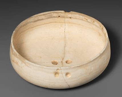
The extraordinary invention: White Ware
This is the feature that makes Neba’a Faour especially important. Before pottery became widespread, people in the Levant developed White Ware. It is sometimes called Vaisselle Blanche.
It was not ordinary pottery
Instead, it involved a lime-based material, produced using limestone and ash and shaped into vessels. White Ware is therefore an important technological bridge between: stone architecture, plaster technology, containers and pottery. Fragments of large White Ware vessels were found at Neba’a Faour, including large dishes and bowls with ring bases. [2,3] Some large vessels have been interpreted as storage containers—effectively portable silos. [3] That interpretation is particularly interesting for Neolithic Architecture because it connects architecture to storage to food production and craft specialization.
One of the most exciting details. Baskets were involved
White Ware vessels could be formed by building lime plaster around basket-like frameworks. Basket impressions on White Ware elsewhere in the Levant demonstrate that the vessel technology could preserve traces of the organic container used during manufacture. [3,9] So although we do not have a preserved basket from Neba’a Faour, the White Ware technology gives us evidence of a larger technological system. Baskets, plaster, containers and storage.

They probably had agriculture but it needs inference from direct botanical evidence
The site produced: sickle blades; querns; basalt grinding rubbers; storage vessels; and other stone-processing equipment. [2,3] Strong indicators of a community involved in processing plant foods. The querns and grinders are particularly important. They imply harvesting, processing, grinding, storage and consumption. A safe archaeological statement is: Neba’a Faour clearly participated in a food-processing and storage economy, but the exact crop list remains poorly documented.
Neolithic communities commonly combined: cultivated cereals; pulses; gathered plants; nuts; wild fruits; hunted animals; domesticated animals; and occasionally aquatic foods (especially near coastal areas). At Neba’a Faour we can confidently identify plant-processing technology, but not the exact percentage of cultivated versus wild foods, or plant verus animal food. The querns and sickles suggest a significant plant-processing component. And, the arrowheads indicate that hunting technology also existed. So the most reasonable model is: farming, gathering and hunting, rather than an exclusively agricultural economy.
The sites location was advantageous because water was naturally available near the settlement
The site appears to have occupied a spring/stream-fed edge of the Beqaa, rather than being a settlement dependent on a large engineered canal system.
The tool assemblage is impressive
It included: flint blades; pyramidal and double-ended cores; Byblos points; Amuq points; tanged pressure-flaked arrowheads; sickle blades; scrapers; burins; retouched blades; borers; axe-like implements; querns; basalt rubbers; and stone vessels. [2,3]
The arrowheads (Byblos and Amuq type)
Byblos and Amuq types are particularly valuable because they allow archaeologists to connect Neba’a Faour with wider Levantine technological traditions.
The sickles
Some were segmented and some backed, with fine or coarse denticulation along their cutting edges. [3] These are excellent evidence for plant-cutting technology.
The axes
Only two axe-like tools with polished edges were found, and Moore notes that they had been reused and therefore were not particularly diagnostic. [3]
Obsidian: evidence of long-distance connections
A small amount of obsidian was found at Neba’a Faour. [3] Important because obsidian does not occur everywhere. Some Levantine and Anatolian obsidian sources were hundreds of miles away. If the Neba’a Faour obsidian could be matched to a source in eastern Anatolia, for example, we could begin reconstructing the movement of raw material through the Neolithic landscape hundreds of miles away
Red pigment was used in the wider Neolithic Levant and red-painted vessels occur in the Beqaa sequence
At Neba’a Faour, some pottery was painted red, although Moore notes that it is uncertain whether those examples belong to the principal phase or a later occupation. [3]
What happened?
The settlement may have changed gradually as part of the broader transformation from earlier Neolithic village systems toward later pottery-producing societies. And there is another possibility that the location was never completely abandoned. The tell contains evidence for occupation in multiple later periods. A landscape study identifies occupation extending through the Chalcolithic, Early Bronze Age, Middle Bronze Age, Iron Age and later periods. [7]
Modern development around the site has been extensive
The geoarchaeological survey comparing 1970 and 2010 satellite/landscape conditions found a dramatic increase in development around Neba’a Faour I and a corresponding reduction in agricultural and undeveloped land. [7] Striking continuity: neolithic people chose the place because it offered water, land and transportation routes. Modern people choose the same region for many of the same geographic reasons.
Neba’a Faour and the birth of pottery maybe the most important lesson from the site
It is tempting to imagine technological history as: stone tools, pottery, metal. The reality was much messier. At Neba’a Faour we see people already possessing: lime-plaster floors; plaster architecture; stone construction; baskets; storage technology; grinding technology; sophisticated flint working; controlled heating; and White Ware vessels. They were experimenting with materials and containers before ordinary clay pottery became dominant. White Ware therefore represents a remarkable technological stage: People wanted pottery-like containers before they had fully adopted pottery.
A big comparison: Neba’a Faour versus Çatalhöyük
Neba’a Faour Çatalhöyük
Lebanon Central Anatolia
Beqaa Valley Konya Plain
~50 km from Mediterranean Far inland
Spring/stream environment Wetland/riverine Konya environment
Stone-footed architecture documented Extensive mudbrick architecture
Plastered floors Plastered floors
White Ware Later established pottery tradition
Small settlement evidence Huge densely packed settlement
Sickle technology Sickle and extensive farming evidence
Obsidian Major obsidian use
Some ritual evidence not established Extensive symbolic/ritual evidence
Much archaeological material from exposed/surveyed deposits Large-scale excavations
They represent different architectural solutions within the same enormous Neolithic transformation.
Who studied Neba’a Faour?
The principal early researchers include: Lorraine Copeland. One of the most important archaeologists of prehistoric Lebanon. She and Peter Wescombe systematically recorded Lebanon’s Stone Age sites and published the inventory that remains fundamental to the archaeology of sites such as Neba’a Faour. [1]
Her article “Neolithic Village Sites in the South Beqaa, Lebanon” is particularly important for understanding Neba’a Faour in its regional context. [2]
Peter J. Wescombe. Collaborator with Copeland in the archaeological survey and inventory of Lebanese prehistoric sites. [1]
A. M. T. Moore. Moore’s The Neolithic of the Levant provides one of the most useful syntheses of the Lebanese material, including detailed descriptions of Neba’a Faour’s stone tools, pottery, White Ware and architectural remains. [3]
More recent geoarchaeological work has documented the vulnerability of the site to agricultural and urban development and provides valuable modern landscape comparisons [7]
Neba’a Faour was a Neolithic settlement where people combined stone architecture, beautifully plastered floors, plant-processing technology, sophisticated flint tools, obsidian and an extraordinary lime-plaster “proto-pottery” called White Ware
And, there is an even bigger lesson. The people of Neba’a Faour were not simply “cavemen who discovered farming.” They were already solving remarkably sophisticated engineering problems: How do we build a durable floor? How do we make a smooth, clean living surface? How do we harvest plants efficiently? How do we grind them? How do we store them? How do we make a container before ordinary pottery? How do we turn limestone into a useful engineered material? How do we make a basket strong enough to become the temporary framework of another material? That is precisely the kind of technological continuity that makes Neba’a Faour valuable for a study of Neolithic architecture as “survival into technology.”
References: [1] Copeland, L., & Wescombe, P. J. (1966). Inventory of Stone-Age Sites in Lebanon. Imprimerie Catholique, Beirut.
[2] Copeland, L. (1969). “Neolithic Village Sites in the South Beqaa, Lebanon.” Mélanges de l’Université Saint-Joseph, 45, 83–114. Neba’a Faour is discussed particularly around pp. 87–89. Moore’s transcription of the relevant material confirms the architectural, lithic and ceramic observations.
[3] Moore, A. M. T. (1978). The Neolithic of the Levant. Unpublished PhD thesis, University of Oxford. The thesis provides an unusually useful description of Neba’a Faour I, including its stone foundations, plaster floors, flint technology, sickles, obsidian, querns, stone vessels and White Ware.
[4] Haïdar-Boustani, M. (2001–2002). “Le Néolithique du Liban dans le contexte Proche-Oriental.” Annales d’histoire et d’archéologie, Université Saint-Joseph.
[5] Geographic information for Neba’a Faour/Nab‘ al-Faour: coordinates approximately 33.78222° N, 35.96806° E; elevation approximately 884 m; identified also as a spring.
[6] Marfoe, L. (1995). Survey and settlement studies of the Beqaa Valley. Later archaeological work has continued to use Neba’a Faour as an important chronological and settlement reference.
[7] Savage, S. H., & Remple, M. (2012). Geoarchaeological/landscape survey data for the Beqaa, including Tell Neba’a Faour I. The study documents substantial modern development of the archaeological landscape between 1970 and 2010.
[8] UNESCO. The Neolithic Site of Çatalhöyük. UNESCO World Heritage nomination and documentation. Çatalhöyük’s coordinates and archaeological chronology provide the basis for the geographic comparison.
[9] White Ware / Vaisselle Blanche studies of the Levant. White plaster vessels are documented at Neba’a Faour, Byblos, Labweh and other Neolithic sites and are important in the technological transition toward pottery.
[10] Hajar, L., Khater, C., & Cheddadi, R. (2008). Pollen and palaeoenvironmental research from the Beqaa/Aammiq region, providing regional evidence for changing woodland and open vegetation during the late Pleistocene and Holocene.
Leave a Reply