<home # start here # guides # builds # services # shop # about # categories>

Tell es-Sawwan is one of the most important Neolithic settlements in Iraq for understanding the transition from early village farming to more complex, organized communities. It is especially valuable for Neolithic Architecture because it combines unusually sophisticated mudbrick architecture, large multi-room houses, an enclosing ditch and wall, cereal agriculture, possible irrigation, specialized craft production, rich under-floor burials, figurines, obsidian, flint, and early evidence of copper.
It is also a site where the older archaeological interpretation needs some updating. The excavators originally regarded the settlement as a roughly 6th–early 5th-millennium BC Hassuna/Samarra settlement, but more recent research has argued that the cemetery beneath the earliest buildings may belong to the mid-7th millennium BC, at the transition from Late PPNB to the earliest Pottery Neolithic. (Helwing 2016).
That makes Tell es-Sawwan potentially important not only for the Samarra period, but also for the PPNB → Pottery Neolithic transition in Mesopotamia

Tell es-Sawwan is in modern central/northern Iraq, in present-day Saladin Governorate, approximately 10–11 km south of Samarra, on the Tigris River. It occupies a low conglomerate cliff overlooking a broad bend of the river.
The site is immediately adjacent to the Tigris
Baghdad is 110km south and Samarra is 10–11 km north. The site is on the east/left side when looking downstream.
Sawwan is generally translated as something like: “Mound of the Flints”
That is a wonderfully appropriate name because chipped stone was an important component of the site’s technology.
The mound itself is relatively small, roughly 230–350 m across depending on how the eroded margins are measured, and consists of three adjacent mounds designated A, B and C. The western portion has been affected by erosion from the Tigris.
The site was first noted by the German archaeologist Ernst Herzfeld during his work at Samarra in the early 20th century
The major archaeological work was then carried out by the Iraqi Directorate-General of Antiquities, beginning in 1964.
The excavators identified five principal building levels, I–V, with III sometimes divided into IIIA and IIIB
Level I–II. Earlier Hassuna/Proto-Hassuna-related material
Level III. Hassuna–Samarra transition
Level IV. Samarra
Level V. Late Samarra, with a small amount of later Halaf material
The old radiocarbon dates included:
5506 ± 73 BP? / older publication reporting ~5506 BC
5349 ± 86
4858 ± 82
The original publications used the old Libby radiocarbon convention and expressed the results in a way that can be confusing today. Modern chronological syntheses generally place the main architectural occupation around the 6th millennium BC, broadly approximately 6000–5000 BC
Under the earliest substantial buildings was a cemetery containing more than 130 burials
These graves were dug into the virgin soil beneath the floors of Level I
Many of the graves contained: alabaster vessels; stone vessels; alabaster figurines; shell beads; bitumen; carnelian; turquoise; and other ornaments. Most of the burials were children, although adolescents and adults were also represented.
Barbara Helwing’s 2016 reassessment argues that the cemetery should probably be dated to the mid-7th millennium BC (earliest Pottery Neolithic).
The earliest cemetery is remarkable for not having pottery
The earliest architectural levels contained pottery, but the under-floor graves of Level I contained no pottery. Instead they contained stone vessels, figurines and ornaments. This is one reason the chronology is so interesting. It could be visualized: late PPNB background to earliest PN cemetery to early pottery-bearing settlement to Hassuna/Samarra to late Samarra to limited Halaf material.
The site’s ceramic sequence includes: crude/coarse wares; incised Hassuna pottery; painted pottery; and classic Samarra painted ware. The Samarra pottery becomes especially prominent in Level III and later.
Both Wheat and Barley were cultivated
Other assemblage includes Wheat: einkorn wheat, emmer wheat, free-threshing/bread-type wheat; barley: two-row barley, six-row barley and naked barley.
The archaeobotanical evidence includes flax/linseed
This is significant because flax is a relatively water-demanding crop and has been used as one line of evidence for irrigation or enhanced water availability at Tell es-Sawwan.
Does the botanical evidence prove formal canal irrigation at Tell es-Sawwan?
Not necessarily. Some researchers have argued that the crops imply irrigation, while others have considered seasonal flooding or other forms of water management sufficient. The evidence for definite canal irrigation is much stronger at Choga Mami.
Two wild plants were present and particularly interesting: Prosopis farcta (mesquite); and, Capparis spinosa — prickly/caper bush. The latter is a useful indication of the surrounding dry environment.
Some broader syntheses also mention pulses and other plants in the Samarra agricultural economy, including: lentils; vetch; and chickpeas.
Sheep and goats were very important
The faunal evidence indicates a mixed farming economy involving domesticated: sheep, goats, cattle, pigs and dogs.
Hunting and fishing
The economy was not entirely domesticated. Wild animals included hunted species such as: gazelle and aurochs. And, the river provided: fish; freshwater resources; and probably aquatic plants and other riverine foods. This is exactly what we would expect from a settlement located directly beside the Tigris.
The landscape provided three complementary resource zones: cultivated fields, pasture/steppe and Tigris river. That is an unusually resilient economic combination.
The architecture is spectacular
The earliest substantial buildings are constructed from large rectangular mudbricks. The first excavated building contained at least 14 rooms, and was built directly over virgin soil. It is strikingly regular.
Included in the buildings were: multiple rooms; corridors; axial doorways; carefully planned room relationships; external buttresses; possible roof-access stairways; and, lanes between buildings.
The corners of buildings were sometimes deliberately oriented toward the cardinal directions.
The great tripartite buildings
The Level I–II buildings are particularly interesting. They are often described as large tripartite buildings because of their division into major central and lateral spaces. Some reached roughly 167 m², making them unusually large for this early period. Later buildings became smaller and more compartmentalized.
This creates an architectural question: Were these houses, temples, communal buildings—or something else?
The early excavators sometimes interpreted them as religious structures because of their regular plans and the extraordinarily rich burials beneath them. But later scholars have been more cautious.
Was there a ritual or communal building?
This is one of the most interesting debates at Tell es-Sawwan. Building 1 contained: a highly regular plan; linked rooms; axial doorways; niches; figurines; and rich burials beneath its floors.
One niche contained an alabaster female figurine. Other figurines were found within the building. The original excavators therefore suggested that the structure might have been a religious building. But modern scholarship is more cautious. There is no unequivocal temple comparable to much later Mesopotamian religious architecture. The buildings may instead have been: large extended-family houses with ritual functions or: special-purpose communal buildings or perhaps a combination of residential, storage and ritual functions.
That ambiguity is important—and actually makes the site more interesting.
The under-floor cemetery
The cemetery is extraordinary. More than 130 graves were excavated beneath Level I buildings. Most were children. Bodies were generally: contracted; placed in shallow pits; and oriented in broadly consistent ways. Some were wrapped in reed mats, with bitumen preserving impressions of the matting. Some burials contained: alabaster figurines; stone vessels; beads; shells; carnelian; turquoise; bitumen; and flint tools. One burial contained a remarkably elaborate assemblage. This suggests that the buildings were not merely places where people lived. They were also places where ancestry, identity and ritual were materially maintained.
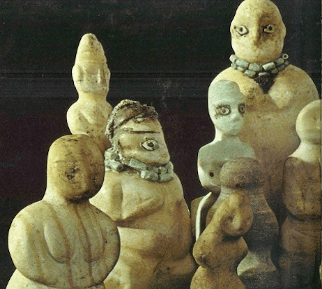
Tell es-Sawwan is famous for its figurines. The site produced: female figurines; male figurines; seated figures; clay figurines; alabaster figurines; figures with shell-inlaid eyes; figures with bitumen caps; and, figurines pierced to function as pendants.
A famous alabaster female figure is now held by the Louvre, on long-term loan from the Iraq Museum. The Louvre catalogue identifies it as a female figurine from Tell es-Sawwan, approximately 6000 BC, made from alabaster.
The Iraq Museum also contains a remarkable group of Tell es-Sawwan figurines.
The traditional term “mother goddess” appears frequently in older literature, but it should be treated as an interpretation rather than a proven identification.
Tell es-Sawwan produced clay tokens, with published summaries reporting around 77 Neolithic clay tokens
They may have served for counting, identification, economic activities, or games.
Sling bullets and weapons is one of the site’s most interesting technological assemblages
Large numbers of clay sling balls were found, especially around the defensive ditch.
The chipped-stone assemblage also included: arrowheads; curved points; scrapers; sickle blades; knives; and, borers.
There is clear evidence for hunting technology and potentially defensive weaponry. But we should not automatically turn the presence of sling balls into evidence of warfare.

The defensive ditch may be the site’s most remarkable architectural feature
An enormous V-shaped ditch, approximately: 2.5 m wide and 3 m deep was cut into the natural conglomerate. It surrounded much of the settlement. Later, a substantial wall/rampart was added.
The original excavators interpreted it as an early defensive system, and the presence of large numbers of sling balls strengthened that interpretation.
Possible explanations include: defenses, control of access, flood/water management, symbolic enclosure and some combination of these.
Flint was extensively used
Blades; flakes; scrapers; sickle blades; arrowheads; borers; and cutting tools.
Obsidian occurs through all five architectural levels
Blades; knives; borers; scrapers; and sickle elements. Some tools were retouched and resharpened. This is excellent evidence for long-distance exchange. Probably ultimately involving Anatolia and/or the broader Near Eastern obsidian exchange network.
A particularly interesting find was a sickle component containing: three flint blades + one obsidian blade set together using bitumen.
The ground-stone assemblage included: hoes; celts; polishers; rubbing stones; palettes; mortars; pestles; mullers; and querns. Consistent with: farming; grain processing; food preparation; woodworking; construction; and pigment preparation. In other words, Tell es-Sawwan’s stone technology was not simply about weapons. It was an entire production system.
There is no large surviving assemblage of wooden doors. That is unsurprising
Wood decomposes extremely easily in this environment. But the architecture provides indirect evidence for substantial woodworking. The buildings had: carefully constructed doorways; axial door arrangements; possible roof stairways; substantial mudbrick walls; and, roofs that must have required timber/reed structural elements.
The settlement also produced bone tools, including: awls; pins; needles; and, spatulas.
Reed technology is particularly interesting
Some burials were wrapped in reed mats, preserved because they had been coated with bitumen. So although a wooden door leaf hasn’t survived, we have good evidence that the inhabitants were exploiting: wood + reed + bitumen, as part of their construction and material culture.
Bitumen is one of Tell es-Sawwan’s particularly interesting materials
It use for coating reed mats; basket construction; attachments; possibly waterproofing; composite tools; and ornamentation. Included two baskets from Level II, that were reportedly caulked with bitumen.
It is a remarkably sophisticated low-energy materials economy.
The earliest excavation did not recover metal, but later work found: copper beads, and a small copper knife
It was found in a Level I burial near a doorway. This places Tell es-Sawwan within the very early history of copper use in Mesopotamia. It is important not to call this a full “Bronze Age” technology. There is no bronze industry here. It was early native/early copper technology.
One of the site’s most extraordinary industries was alabaster working
The inhabitants produced: bowls; plates; cups; flasks; vessels; figurines; pendants; and, unusual symbolic objects. The excavation team even found an unfinished figurine, providing direct evidence for manufacture. It’s important. It means the spectacular objects were not necessarily imported finished products. Some were made locally.
Burials contained ornaments made from: dentalium shells, other shells; carnelian; turquoise; green stones; bitumen; and, alabaster. These materials imply exchange networks extending well beyond the immediate Tigris valley. The presence of obsidian + turquoise + carnelian + marine shell is particularly useful evidence for a site connected to multiple exchange corridors.
What about a ritual building?
Ritual/communal building: possible; no unequivocal temple. There are strong reasons to suspect ritual activity: rich cemetery; figurines; unusual alabaster objects; niches; repeated burial beneath floors; exceptionally regular large buildings..But the evidence doesn’t permit us to say confidently: “This was a temple.” A better description is: Large tripartite buildings with possible ritual functions and extensive associated under-floor burial activity. That is both more accurate and more interesting.
A important question: Was climate different from today?
The site lies today in a semi-arid environment, and rainfall is insufficiently reliable for the kind of intensive agriculture documented archaeologically without some form of supplementary water management. The site is therefore an important example of an ancient settlement exploiting: river water + floodplain soils + seasonal precipitation. The broader Holocene climate history shows considerable hydroclimatic variability in Southwest Asia. A recent speleothem record from Iraqi Kurdistan shows major fluctuations in precipitation through the Neolithic, including wetter intervals followed by increasingly variable and, later, more arid conditions. For Tell es-Sawwan specifically, we should therefore avoid claiming that: “The climate was much wetter than today.” The evidence is more nuanced. The inhabitants were living in a drying/seasonally dry landscape in which reliable access to the Tigris was an enormous advantage.
Climate adaptation and irrigation
This is where Tell es-Sawwan becomes very interesting for modern architecture projects. The settlement appears to have combined: river access, water management, cereal agriculture, livestock, storage and defensible architecture. This is an integrated adaptation system. Rather than attempting to make the environment behave like a wetter region, the inhabitants exploited the environmental feature they already had: the Tigris river.
Was irrigation definitely present?
There was [robably some form of artificial water management but the exact mechanism is debated. The archaeobotanical evidence has traditionally been interpreted as evidence for irrigation, particularly because of: flax; cereal characteristics;
the location outside the reliable rain-fed zone. But researchers have disagreed over whether this represents: formal canals; seasonal flooding; floodwater management; and small-scale irrigation. The evidence for clearly identifiable canals is stronger at Choga Mami.
The original excavation report concluded that Tell es-Sawwan was occupied through its five architectural levels and was then effectively abandoned, with only limited later material
The pottery sequence is particularly useful because the excavators saw continuity between the levels, rather than evidence for a major invasion or abrupt population replacement. The uppermost level contained predominantly Samarra pottery and a single Halaf sherd in the ditch. Thus: There was not a series of repeated major destructions and rebuildings by unrelated populations. Instead, the settlement seems to have developed through a continuous local sequence before eventually ending.
The architectural sequence: Five principal Neolithic building levels I, II, III/IIIA-IIIB, IV, V
Phase 0 — Early cemetery. Possible Late PPNB → earliest PN. Under-floor/under-building cemetery.
Phase I–II. Large rectangular mudbrick buildings. Multi-room, tripartite, regular geometry, and ritual/burial associations.
Phase III. Fortified settlement. Ditch, wall/rampart, T-shaped buildings, small storage rooms, increasing settlement organization
Phase IV. Samarra settlement. Painted pottery and continued mudbrick architecture
Phase V. Late Samarra. Reduced preservation, little architecture, Samarra pottery and isolated Halaf sherd
Abandonment.
An especially powerful neolithic site for modern-building
The inhabitants didn’t solve every problem with one technology. They built a system: Tigris: water, mud: bricks, reeds: mats/baskets, bitumen: waterproofing/adhesive, timber: roof structures, flint: tools, obsidian: premium cutting edges and trade, earth: enclosure, grain: food security, architecture: organization + protection + storage + ritual.
A remarkable principal that resilient architecture is not one material or one technology; it is a locally adapted system in which materials, climate, food, water, labor and social organization reinforce one another.

References: El-Wailly, F. & Abu al-Soof, B. (1965). The Excavations at Tell es-Sawwan: First Preliminary Report (1964). Sumer 21, 17–32.
Abu al-Soof, B. (1968, 1971). Reports on subsequent seasons at Tell es-Sawwan, published in Sumer.
Youkana, D. G. (1986). Architecture of the Sixth Millennium B.C. in Tell Es-Sawwan. University of Baghdad. T
Oates, J. (1966). The Baked Clay Figurines from Tell Es-Sawwan. Iraq 28(2), 146–153.
Helwing, B. (2016). Reconsidering the Neolithic graveyard at Tell es-Sawwan, Iraq. Paléorient 42(1), 123–136.
Breniquet, C. (2016). Tell es-Sawwan, Irak. Essai de synthèse et de prospective sur la néolithisation de la plaine mésopotamienne. Paléorient 42(1), 137–149.
Helbaek, H. (1964). Studies of cultivated plants from Tell es-Sawwan
Leave a Reply