home # start here # guides # builds # services # shop # about # categories>
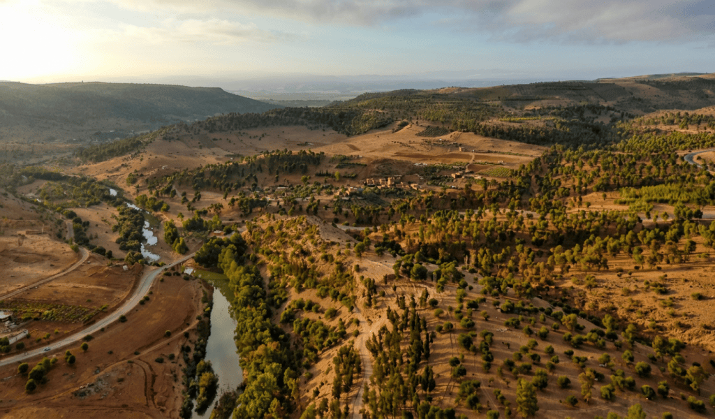
Oued Beht is in northwestern Morocco, in Khémisset Province, on the Zemmour Plateau, between the Atlantic coast and the Middle Atlas.
The archaeological site occupies a long limestone, marl and conglomerate ridge at approximately 170–210 m above sea level, with the highest parts reaching about 211 m. The prehistoric activity extends across approximately 9–10 hectares, with the newest 2023 work suggesting the northern Final Neolithic zone may be approximately 10–11 hectares. [1–3]
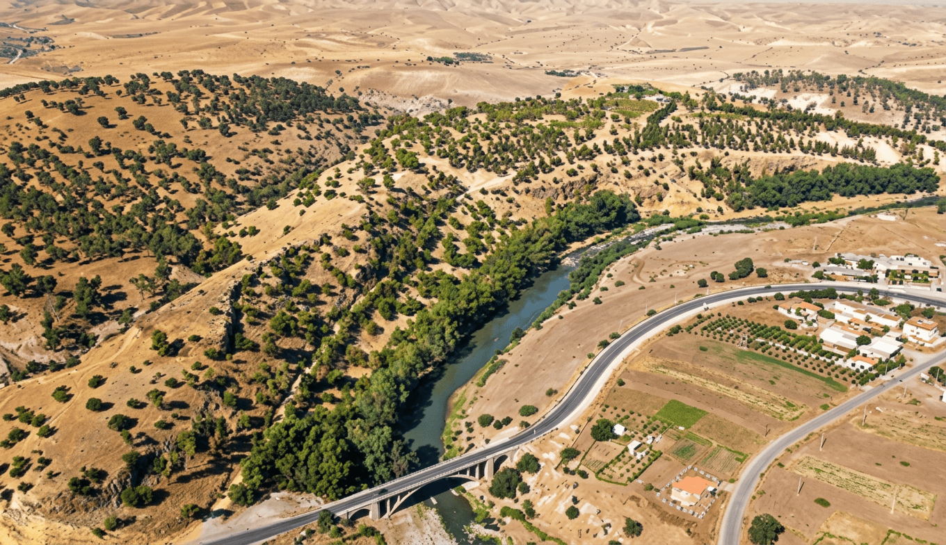
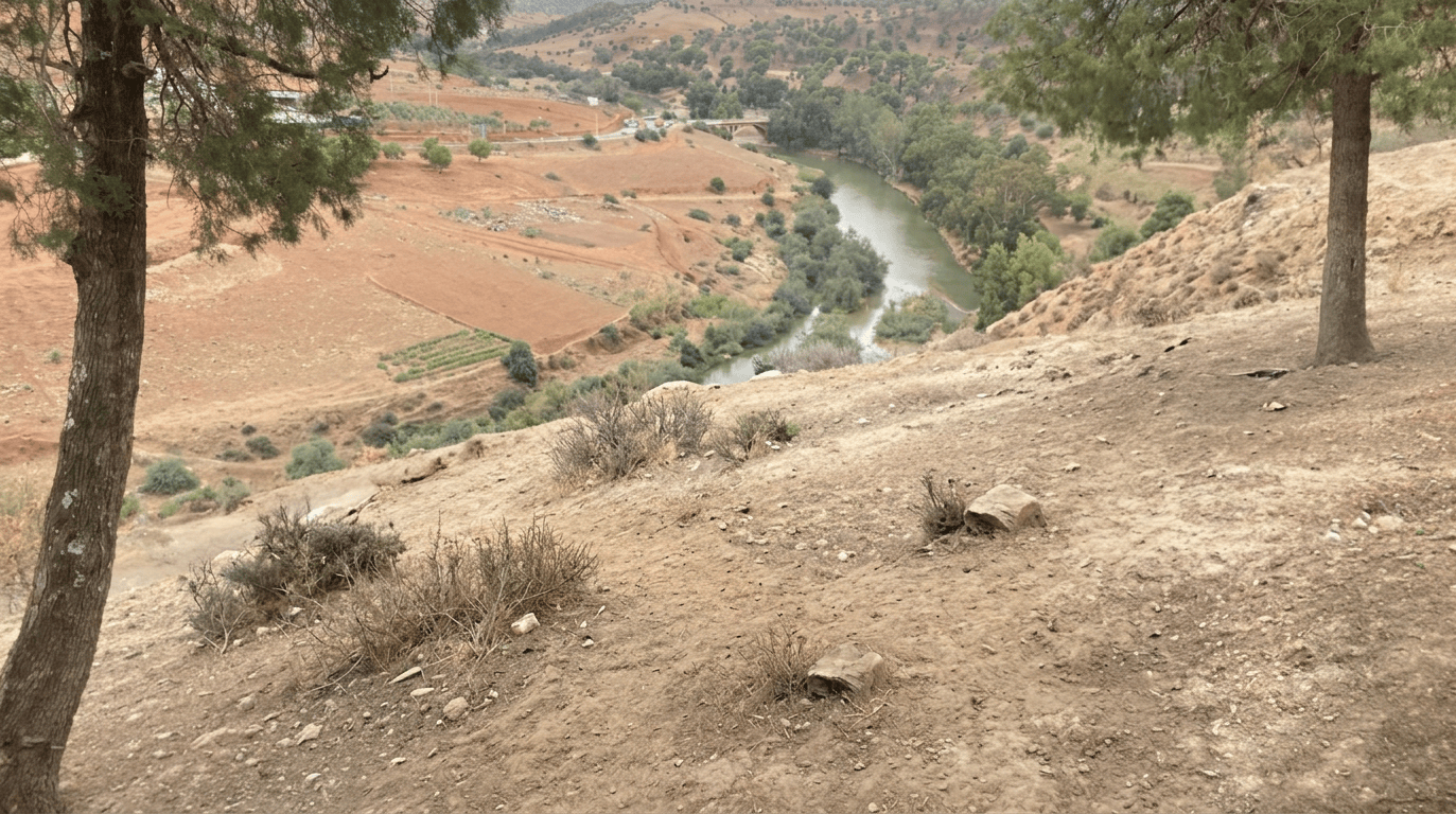
This is important architecturally: it was not a cave settlement. It was primarily an open-air settlement/landscape on a ridge overlooking a river. The ridge is surrounded by steep slopes and smaller drainage channels. Its eastern side drops toward the Oued Beht itself. [2]
The river
The name Oued Beht literally refers to the river.
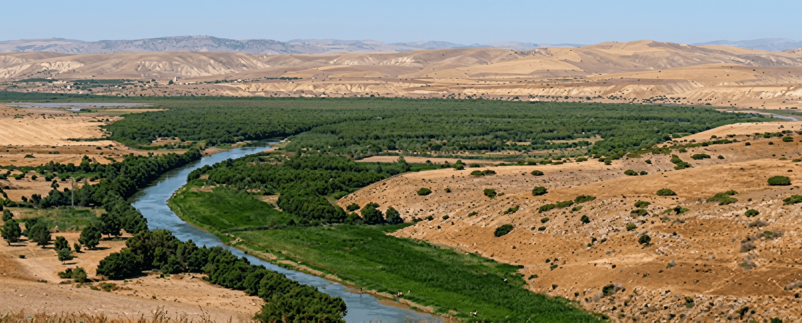
The river flows northward from the Middle Atlas, passes beneath the archaeological ridge, eventually joins the Sebou River, crosses the Gharb lowlands and ultimately reaches the Atlantic Ocean. [2]
So the hydrological sequence was: Middle Atlas to Oued Beht to Sebou to Gharb lowlands to Atlantic Ocean. This is an exceptionally useful setting for understanding the site.
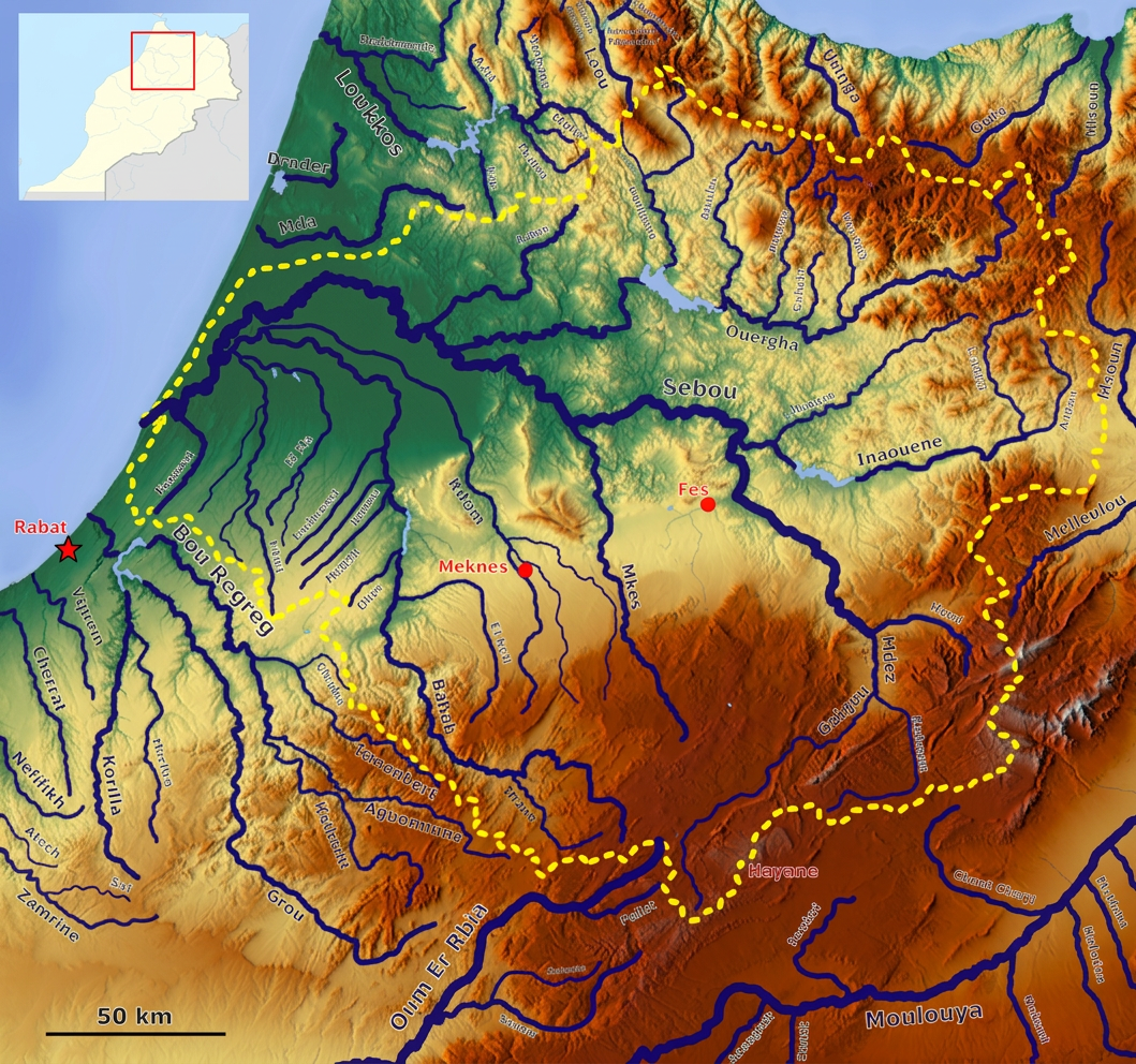
The river was not some distant water source. It ran immediately below the settlement ridge. A natural ford is recorded approximately 1 km downstream of the archaeological site, suggesting that crossing the river was an important part of movement through the landscape. [2]
There are also freshwater mussel/bivalve remains at the archaeological site, providing direct evidence that the river was part of the site’s resource environment. [2]
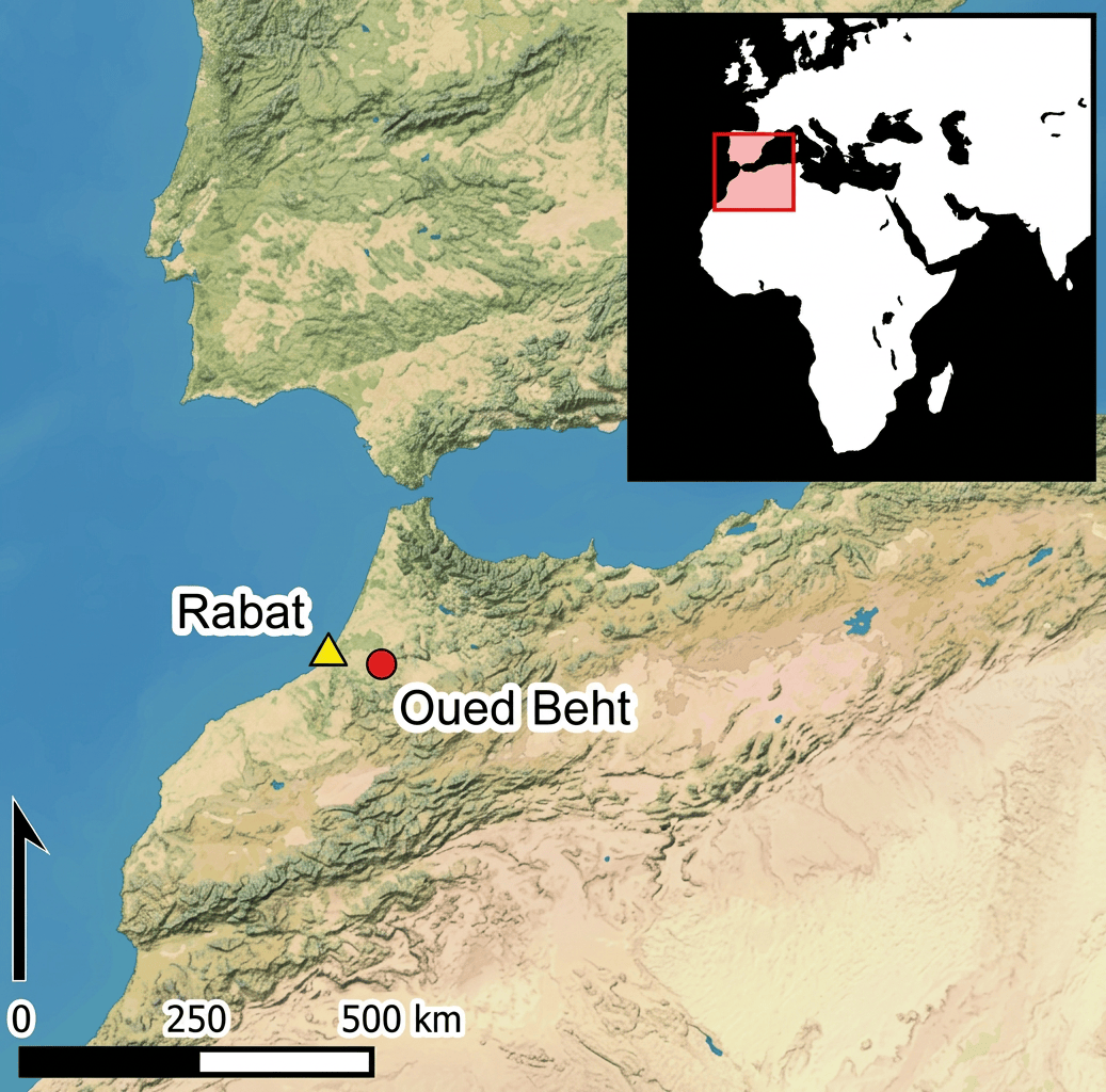
Today the site is approximately 80 km from the Atlantic coast as the crow flies. Another description gives roughly 100 km depending upon how the measurement is made. [1,2] But this is where the ancient landscape becomes fascinating. The researchers propose that the Gharb lowlands to the north were probably much wetter and may have contained an estuarine or lagoonal environment during later prehistory. If so, people living at Oued Beht could potentially have reached a navigable wetland/estuarine zone after travelling only around 30–40 km downstream, rather than having to travel the full modern distance to the open ocean. [2] That remains a palaeogeographical hypothesis, not a proven ancient boat route. Nevertheless, the landscape was potentially: farm, river, wetland/estuary and Atlantic. That makes Oued Beht much more maritime-connected than its inland position on a modern map initially suggests.
Was there a lake?
No large lake is currently known directly at Oued Beht. The important water body was the river, plus smaller seasonal drainage channels and potentially much wetter lowlands downstream. There is an interesting distinction here: Oued Beht itself, perennial river. Immediate archaeological ridge: no known natural lake. Gharb downstream: probably much wetter than today and possibly partly estuarine/wetland. Atlantic: ultimately downstream through the Sebou system.
The archaeologists specifically note that there are no obvious permanent water sources on the ridge itself today, making the river the most likely prehistoric source of fresh water, perhaps supplemented by rainwater collection. [3]
How much bigger was the Oued Beht River 4,000, 6,000 and 8,000 years ago?
One of the questions where it is important not to manufacture a number. There is currently no reliable published reconstruction saying that the Oued Beht was, for example, twice or three times wider 6,000 years ago. The archaeological team has documented ancient fluvial deposits and geomorphological terraces, but a quantitative palaeodischarge reconstruction for the river at 4, 6 and 8 ka has not yet been established. [2,3]
Time. What can safely be said?
8,000 years ago Regional climate was undergoing major Holocene changes; river discharge cannot yet be quantified for this location.
6,000 years ago The broader Moroccan climate was transitioning toward a different mid-Holocene regime; Oued Beht was already part of a long-lived drainage system.
4,000 years ago The river remained a perennial part of the landscape, but the famous Oued Beht settlement was already disappearing around this period.
Today The river is perennial and joins the Sebou before reaching the Atlantic.
There is good evidence that the river system itself is ancient, with fluvial deposits and changes in river base level connected to broader sea-level and geomorphological changes. [2]
An important caution
A wetter climate does not automatically mean a permanently larger river. River size depends upon rainfall, seasonality, upstream snow, evaporation, vegetation, soils, groundwater and the geometry of the channel. A prehistoric river could have had larger floods without being continuously wider. That distinction is particularly important for Oued Beht.
The most important mountain system is the Middle Atlas
The Oued Beht rises in the Middle Atlas, and the river transports stone and other geological material downstream. The archaeological site therefore had access to materials originating from a much larger mountainous watershed. [2] The site itself, however, was not a mountain settlement. It was on a relatively low rolling plateau, surrounded by: limestone ridges; marl; conglomerate; river valleys; and rolling agricultural land. The Middle Atlas was farther upstream. This is a useful architectural contrast: Oued Beht was a lowland agricultural settlement with a mountain-fed river—not a high-altitude mountain village.
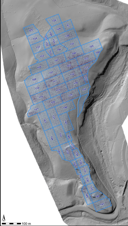
The principal settlement was an open-air ridge-top settlement
But there is a very important cave immediately associated with the landscape: Ifri n’Amr o’Moussa. The cave Ifri n’Amr o’Moussa lies at the southern end of the same ridge. It contains a much longer prehistoric sequence, including: Epipalaeolithic occupation; Early Neolithic occupation; Neolithic burials; domesticated barley; later Beaker-period activity; and later prehistoric activity. [2,3]
This makes the Oued Beht landscape particularly interesting because it contains two different kinds of architecture: Cave architecture at Ifri n’Amr o’Moussa; and, open agricultural architecture at Oued Beht. The latest research suggests that the northern open-air settlement and the southern cave should be understood as parts of a longer-lived landscape rather than as isolated sites. [2,3]
Was it an extreme environment?
No, Oued Beht lies in a Mediterranean-type, semi-arid environment. Modern Khémisset receives roughly 481 mm of annual precipitation, mostly during the winter, although rainfall varies considerably between years. [2] So this was not: Sahara desert; hyper-arid interior; or, extreme mountain environment. It was instead a seasonally dry agricultural environment with a reliable river. A combination is extremely valuable for farming. The people had: winter rain, river water, fertile soils, upland fields, grazing land, woodland resources and access to downstream wetlands.
What happened to the climate between 10,000 and 4,000 years ago?
This is complicated because Morocco did not simply become progressively drier every year. Pollen studies from the Middle Atlas show a substantial Holocene transformation. One quantitative reconstruction indicates that approximately 10,000–6,500 years ago, temperatures were around 4°C warmer than today in the particular Middle Atlas record studied, while precipitation was estimated around 870 mm/year. Temperatures then declined markedly between about 7,000 and 6,000 years ago. [7]
Other Moroccan palaeoenvironmental records identify a warmer/humid optimum broadly around 6,000–4,500 years ago, followed by a return toward more arid conditions around 4,000 years ago. [8]
There was also a major climatic disturbance around 8,200 years ago, associated with abrupt cooling/drying in many northern-hemisphere records. [9]
What about the famous 4.2 ka event?
This is where I would be cautious. The 4.2 ka event was real in many places, but modern palaeoclimate research shows that it was not a single globally identical megadrought. Its intensity and timing varied substantially by region. [9] For Morocco, the broader picture is better described as mid-Holocene climatic transition, increasing aridity/seasonality and greater environmental uncertainty. Rather than: one enormous drought suddenly destroyed Oued Beht. And that distinction matters because Oued Beht’s principal occupation ended around 2900 BC, while the classic 4.2 ka event is roughly 2200 BC. So the settlement’s disappearance cannot simply be blamed on the 4.2 ka event.
Did they live in subterranean huts? Probably not
This is an important architectural finding. Oued Beht contains many subterranean pits, but the excavators interpret the major bell-shaped pits primarily as storage features, not houses. [1–3] Many are approximately 1–2 m³ in capacity and have narrow mouths with expanding/bell-shaped interiors. [1] This is fascinating because underground storage creates a naturally buffered environment. A simple version would be: small opening, wide underground chamber, grain stored below ground and soil provides thermal buffering. The Moroccan tradition known as matmora uses underground grain-storage pits today, although we should not automatically assume the ancient pits were identical to modern matmora. [1]
Did they have timber-frame buildings?
There is good evidence for above-ground structures, but the complete house plan is still uncertain. Archaeologists have found: postholes; structural daub; vegetal impressions in daub; mud plaster; and possible brick-like pieces. The current interpretation is that at least some of this daub probably came from above-ground buildings, potentially houses or other structures. [2] So a reasonable reconstruction would be: timber posts, woven vegetal framework, mud/daub plaster and roof. But this is a reconstruction, not a completely excavated house. The evidence does not yet allow us to say exactly how large the houses were, what their roof geometry was, or whether they used wattle-and-daub in the strict technical sense.
A particularly good subject for our architecture website: ‘archaeological evidence allows a reconstruction, but also demonstrates where reconstruction becomes interpretation.’
Were there hearths?
Fire was certainly used. Charcoal, carbonized seeds and other burnt organic material are present. But the published Oued Beht excavations have not yet produced a spectacular, well-preserved architectural hearth complex comparable with some other Neolithic settlements. [2,3]
Cooking and fire use are demonstrated by charcoal and carbonized food remains, but the architecture of individual cooking installations remains poorly documented.
Benches and chairs?
No convincing Neolithic chairs or formal benches have been identified. However, organic furniture made from: wood; reeds; grass; leather; and woven fibres; could disappear almost completely. This is a recurring problem in archaeological architecture.
How long would wood survive here? Oued Beht’s environment is not especially favourable to preserving ordinary structural wood
In an oxygenated, seasonally wet/dry Mediterranean soil, unprotected wood can be destroyed by: fungi; bacteria; insects; termites; repeated wetting and drying; and oxidation. Large unburned timbers therefore normally disappear archaeologically unless they enter unusual preservation environments. The most durable evidence is often: posthole, decayed post, soil stain and surviving negative impression. Rather than the wood itself.
Charcoal is another story. Burned wood can survive for thousands of years, which is why Oued Beht has charcoal suitable for radiocarbon dating, even though actual structural timbers have not survived [2]
So the absence of wooden beams does not mean there were no wooden buildings.
The most exciting question. What was the settlement actually like?
The archaeological footprint covers roughly 9–10 hectares, with the 2023 work suggesting approximately 10–11 hectares for the northern Final Neolithic concentration. [3] There are: hundreds of archaeological features; numerous storage pits; pottery; grinding stones; polished axes; chipped stone; animal remains;
crop remains; postholes; daub; and activity surfaces.
The settlement appears to have been densely organized, although archaeologists still cannot say whether it was a conventional village, a regional aggregation centre, a seasonal gathering place, or some combination. The researchers deliberately avoid prematurely calling it a “city.” A better description is ‘a large agricultural settlement and production/storage centre occupying a strategically positioned river ridge.’
The extraordinary storage system
This may be Oued Beht’s greatest architectural discovery. The site contains large numbers of underground bell-shaped pits, many interpreted as silos. Some pits have approximately 1–2 m³ capacity. They are so numerous that storage appears to have been one of the principal functions of the settlement. [1–3] That is an unusually nice archaeological clue. The architecture therefore potentially consisted of: field, processing, grinding, cooking, storage and redistribution. Rather than simply house, garden and family food.

Did they have sophisticated cooking technology?
For the fourth millennium BC, yes—but not necessarily in the form of complicated mechanical technology. Their sophistication was systemic. They had: ceramic cooking vessels; storage vessels; grinding stones; anvils; hammerstones; polished axes/adzes; sickle elements; underground storage; and crop-processing infrastructure. The sheer quantity of grinding equipment is remarkable. More than 200 grinding implements were identified in the large surface assemblage, along with numerous multipurpose tools. [2]
This is an important architectural point: the technology of food production was built into the settlement itself. The “machine” was not a single object. It was the combination of: field, sickle, grinding stone, pottery, fire, storage pit, river and people. A conservative “architecture as survival system” approach.
Did they weave textiles?
Here the evidence is surprisingly negative. Bone tools have been recovered and might relate to: basketry; leatherworking; and other organic crafts. But archaeologists currently report a striking absence of surviving spinning and weaving equipment. [2] So textiles probably existed but textile production at Oued Beht has not yet been demonstrated archaeologically. This is another good example of why organic technology is difficult to see. A woven bag can disappear completely while the stone tool used to process the crop remains for 5,000 years.

What crops did they grow? One of the strongest parts of the evidence
The excavated botanical assemblage contains: Confirmed crops naked barley (Hordeum vulgare var. nudum), Wheat (Triticum sp.), Pea (Pisum sativum) and additional indeterminate legumes (Fabaceae). [2]
Naked barley was by far the most common identified crop, making up approximately 57% of the plant remains in the analysed sample. [2] The wheat is currently difficult to identify more precisely because the surviving material consists of grains rather than diagnostic chaff.
Wild foods/plants
They also had: wild pistachio (Pistacia atlantica/terebinthus); and wild olive (Olea europaea subsp. oleaster). [2] The wild pistachio and olive are especially interesting because they show that the agricultural economy existed alongside exploitation of the surrounding landscape.
Was this an agricultural or nomadic society?
The evidence strongly favours agriculture and herding as the economic foundation. The combination of: domesticated cereals; peas; sheep; goats; cattle; pigs; massive grinding-stone quantities; sickle elements; and storage pits. Is difficult to interpret as a primarily nomadic economy. [1–3]
It looks like a society investing heavily in food production and surplus management. But ‘agricultural’ does not mean that every person lived permanently in one house. They could have: moved livestock seasonally; visited grazing areas; hunted; exchanged goods; travelled to the coast; traded with Iberia; and maintained satellite farms. So the best description is: sedentary or semi-sedentary agricultural society with pastoral mobility.
What animals did they have?
The archaeological assemblage contains: Domestic animals, goat, sheep, cattle, pig and probably an equid, represented by a single tooth. [1,2]
Goats and sheep dominate the analysed sample.
The cattle appear relatively small and are provisionally interpreted as domestic cattle, although the researchers appropriately caution that wild aurochs cannot yet be completely excluded. [2]
Pig remains are less secure because the researchers cannot yet determine whether all the Sus material represents domestic pig or whether some represents wild boar. [2]
What did they eat?
The evidence points toward: barley, wheat, peas, sheep/goat, cattle and pig. With additional wild resources such as: pistachio; wild olive; freshwater shellfish; and probably other wild foods not yet fully identified.
Whole animal carcasses appear to have been butchered at the site, with cut marks and extensive bone breaking indicating meat processing and marrow extraction. [2]
This is primarily a herding society, rather than a hunting society.
What stone tools did they have?
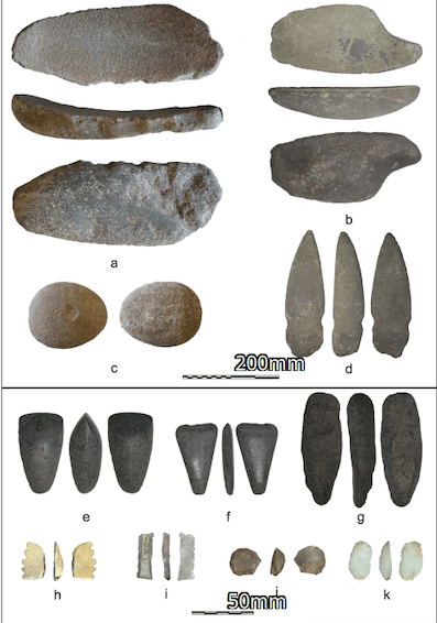
This is one of Oued Beht’s spectacular features. The site has produced huge quantities of: polished axes; adzes; axe/adze preforms; grinding stones; anvils; hammerstones; picks; polishers; sickle elements; endscrapers; chipped-stone tools; and bipolar percussion products. [1,2]
At least 1,388 polished axes/adzes are currently curated in Moroccan institutions from the older collections, although their original spatial provenience is not always secure. [1] The new excavations also found evidence suggesting that stone-tool manufacture occurred at Oued Beht itself. Which is particularly significant. The site wasn’t merely consuming imported tools. It appears to have been a production centre.
The principal macrolithic materials include: sandstone; quartzitic sandstone; basalt; schist; breccia; limestone; granitoid; volcanic stone/tuff-like material; and rarer diorite/dolerite-like rocks [2]
Many of the preferred sandstone/quartzitic sandstone materials were probably available locally, including from river gravels and conglomerates. A beautiful example of the river acting as a geological conveyor belt. The Middle Atlas supplied geological diversity upstream; the Oued Beht transported cobbles downstream.
What about flint? Yes
There is a substantial chipped-stone industry, including sickle elements and other cutting tools. [1,2] The presence of: sickle blade, cereal, grinding stone and storage pit. Is especially compelling evidence for agricultural organization.
Did Oued Beht trade with Algeria?
There was certainly regional interaction across North Africa, but a specific Oued Beht to Algerian mountain trade route for a particular mineral has not yet been demonstrated. The broader Maghreb was connected. For example, domesticated barley is documented in Neolithic/prehistoric Algeria, and northern Algerian sites such as Gueldaman form part of the wider agricultural story. [2] But there interregional connections was probably primarily through the western Mediterranean, especially Iberia.
Iberia: the really exciting connection
This is one of the things everyone should know about Oued Beht. The site has an unusual painted pottery tradition. Some of its decorative styles have parallels in southern Spain. The researchers therefore argue that Oued Beht participated in interaction across the western Mediterranean rather than existing as an isolated Moroccan farming community. [1–3] This means the geography could have looked something like: Oued Beht, Gharb wetlands, Atlantic coast. And, southern Iberia. This is one of the strongest reasons the site is changing the story of later prehistoric North Africa.
Did they have gold, copper or precious metals?
The great Final Neolithic Oued Beht assemblage is notable for its absence of metal objects. The later landscape did develop metalworking and copper-related activity, but the major 3400–2900 BC Oued Beht complex is essentially a stone-and-ceramic agricultural society. [1]
The 2023 investigations found evidence for a later second-millennium BC phase, including copper-based material, but that belongs to a later period and should not be mixed into the Final Neolithic story. [3]
Figurines? No famous monumental figurine tradition has yet emerged from Oued Beht
Their material culture is much more strongly oriented toward: food, tools, storage, pottery and production.
Burials and ochre
There are reports of human remains in and around the site, but their chronology is not yet securely established for the Final Neolithic settlement. [2] The 2023 investigation specifically investigated a possible cemetery, but the securely dated burials it uncovered were medieval, not Final Neolithic. [3]
The nearby Ifri n’Amr o’Moussa cave, however, contains securely documented Early Neolithic burials.
Wall art or cave art?
The main open-air settlement is not known for a spectacular rock-art tradition. There is, however, a cave with prehistoric occupation nearby—Ifri n’Amr o’Moussa. The most important visual material from Oued Beht itself is instead the painted pottery. Interesting because the “canvas” shifted from cave wall to ceramic vessel. As people increasingly occupied open agricultural landscapes.
Were there ritual or communal buildings?
There is no securely identified temple, shrine or ceremonial building at the Final Neolithic Oued Beht settlement. There are substantial linear walls and earthworks in the southern part of the ridge, but the new research has shown that these cannot simply be labelled a Neolithic fortress.
The best-dated substantial defensive/embankment construction belongs to the early–middle second millennium BC, considerably later than the principal Final Neolithic settlement. [3]
What about packing, baskets and organic containers?
This is an interesting possibility. The site has: bone tools potentially associated with basketry/leatherworking; underground storage; cereal remains; and enormous quantities of pottery. But actual baskets, sacks, woven bags and wooden containers are poorly preserved. The most convincing clue is the storage architecture itself. A subterranean silo effectively becomes a giant storage container made from the earth. That is a form of architecture-as-packaging: The container is the ground.
Did they use sophisticated thermal technology?
There is no evidence for a sophisticated built heating system comparable to the kana-type systems discussed for some Far Eastern Neolithic sites. There architectural strategy appears simpler: thick earth/daub; underground storage; naturally elevated ridge; river access; open-air cooking; ceramic vessels; and fire. Its actually a good example of passive environmental engineering. The people did not necessarily need a complicated heating machine if: site selection, soil, shelter, fire, clothing and seasonal behaviour solved the problem.
What’s the architectural lesson of Oued Beht?
This may be the most important part for Neolithic Architecture. Oued Beht demonstrates that architecture does not have to mean a beautiful standing building. The settlement’s “architecture” included: Landscape architecture. A ridge overlooking a river.
Water architecture. Access to a perennial river and downstream wetlands.
Agricultural architecture. Fields and processing areas.
Food-processing architecture. Hundreds of grinding implements.
Storage architecture. Numerous subterranean silo-form pits.
Building architecture. Postholes and mud/daub remains.
Ceramic architecture. Cooking and storage vessels.
Transport architecture. A strategically located river crossing.
Together they form a survival machine.
What happened around 3,000 BC?
The Final Neolithic concentration appears to decline after roughly 2900 BC, although the exact sequence is still being worked out. The radiocarbon evidence currently gives a broad possible range of approximately 3800–2700 BC, with the strongest concentration around 3400–2900 BC. [2] Importantly, this does not mean: “Everyone suddenly left because of climate change.” There is evidence for later prehistoric activity. The 2023 excavations demonstrated a significant second-millennium BC occupation, particularly in the southern sector. [3]
A better model is: large Final Neolithic farming centre to decline/dispersal or transformation to later prehistoric reoccupation
Rather than permanent abandonment forever.
There is no single proven explanation why
Possible factors include: 1. Climate variability. Increasing aridity and changing seasonality may have made agricultural production less predictable.
2. Economic transformation. The communities may have reorganized their settlement and exchange systems.
3. Changing Mediterranean connections. Relationships with Iberia and other regions were changing during the fourth/third millennium transition.
4. Landscape change. River, wetland and soil conditions inevitably changed.
5. Social reorganization. The settlement may have been a particular kind of aggregation centre rather than a permanently expanding town.
The evidence currently supports transformation better than catastrophic abandonment.
How do archaeologists actually identify climate change? Worth explaining
Archaeologists don’t simply look at a landscape and say: “It looks dry.” They combine independent evidence.
Pollen. Pollen tells us what plants were growing.
Charcoal. Charcoal can indicate woodland composition and fuel use. River sediments. Gravel, silt and clay layers can reveal changes in flooding and erosion.
Soil micromorphology. Tiny features in soil can record: wetting; drying; carbonate formation; erosion; and human disturbance. Oued Beht’s researchers used micromorphology and found evidence for repeated wetting and drying in the fills of some pits. [2]
Radiocarbon. Seeds and charcoal establish when people were doing things.
Archaeobotany. The changing proportions of crops and wild plants provide clues about farming and environment.
Faunal evidence. Animals can indicate: woodland; grassland; aridity; pastoral practices; hunting pressure.
Stable isotopes. Elsewhere in Morocco, isotopes can be used to reconstruct rainfall, temperature, vegetation and water conditions. And,
The strongest reconstruction comes when several independent methods agree.
Was there anybody there 12,000 years ago?
The nearby Ifri n’Amr o’Moussa cave provides evidence for Epipalaeolithic activity and an Early Neolithic sequence. [2,3] People were living in this broader landscape thousands of years before the great Oued Beht farming settlement appeared, but the 9–10 hectare open settlement belongs mainly to the later fourth millennium BC.
Oued Beht shows that complex farming societies were developing in North Africa at exactly the time when archaeologists traditionally looked elsewhere—especially toward Egypt, Iberia and the Near East
It is currently described by its investigators as the earliest and largest agricultural complex known in Africa outside the Nile corridor for this period. [1,2] And, it was not simply an agricultural hamlet.
It had: large-scale crop processing; underground storage; domesticated animals; sophisticated pottery; painted ceramics; polished stone-tool manufacture; chipped-stone production; substantial above-ground structures; access to a perennial river; possible access toward Atlantic wetlands; and connections with southern Iberia. That makes Oued Beht extraordinarily important.
Oued Beht in one architectural diagram. The site can be conceptualize the settlement like this:
MIDDLE ATLAS to Oued Beht river, to river crossing / freshwater / stone / mussels;
RIDGE-TOP SETTLEMENT that’s 9–11 hectares, to houses / postholes / daub to grinding stones + sickles, to barley + wheat + peas, to pottery to underground silos, to stored food / surplus to livestock: sheep + goats + cattle + pigs; and, Oued Beht, Sebou, Gharb wetlands and Atlantic;
SOUTHERN Iberia; and,
Immediately south: Ifri n’Amr o’Moussa cave, an older occupation with Early Neolithic farming and burials
That is an unusually coherent architecture-of-survival landscape.
References: [1] Broodbank, C., Lucarini, G., Bokbot, Y., Benattia, H., Bigoulimen, A., et al. (2024). Oued Beht, Morocco: a complex early farming society in north-west Africa and its implications for western Mediterranean interaction during later prehistory. Antiquity 98(401): 1199–1218. This is the key publication establishing the large Final Neolithic agricultural complex, its chronology, storage pits, crops, animals, stone tools and Mediterranean connections.
[2] Broodbank, C., Lucarini, G., Bokbot, Y., Wilkinson, T., et al. (2024). The prehistoric site of Oued Beht, Khémisset, Morocco: an interpretative report on 2021–2022 fieldwork and associated research. Libyan Studies 55: 10–47. Especially important for architecture, pits, daub, lithics, archaeobotany, faunal remains, geology and radiocarbon dating.
[3] Lucarini, G., Bokbot, Y., Wilkinson, T., Benattia, H., Bigoulimen, A., et al. (2026). Expanding Oued Beht: Final Neolithic, Bronze Age, medieval and later discoveries from excavation and survey in 2023. Libyan Studies, published online 7 September 2026. This is the newest major fieldwork report and substantially updates the chronology, site extent and later prehistoric architecture.
[4] Ruhlmann, A. (1936). Early archaeological report on Oued Beht, including its polished axes/adzes and major linear structures. This is the earliest major archaeological recognition of the site.
[5] Morales, J., Pérez-Jordà, G., Peña-Chocarro, L., Bokbot, Y., Vera, J.C., Martínez Sánchez, R.M. & Linstädter, J. (2016). Research on the introduction and development of domesticated plants in Neolithic Morocco. Particularly useful for placing Oued Beht’s crops in the longer Moroccan agricultural sequence.
[6] Martínez Sánchez, R.M., Vera-Rodríguez, J.C., Pérez-Jordà, G., Peña-Chocarro, L., Bokbot, Y., et al. (2018). The beginning of the Neolithic in northwestern Morocco. Quaternary International 470B: 485–496. Important for the earlier Neolithic sequence around Ifri n’Amr o’Moussa and the surrounding region.
[7] Cheddadi, R., Lamb, H.F., Guiot, J. & Van der Kaars, S. (1998). Holocene climatic change in Morocco: a quantitative reconstruction from pollen data. Climate Dynamics 14: 883–890. Useful for the Middle Atlas palaeoclimate and the 10–6 ka climatic transition.
[8] Research on Holocene vegetation, sedimentation and climate in Morocco indicating a warmer/humid optimum around approximately 6000–4500 BP followed by increasing aridity around 4000 BP.
[9] Recent global palaeoclimate synthesis of the 8.2 and 4.2 ka events. Particularly useful for avoiding the older oversimplification that the 4.2 ka event was one uniform worldwide megadrought.
[10] Hilmi, M., Mahamoud, A., El Agbani, M. & Qninba, A. (2022). Environmental and hydrological research on the Oued Beht basin and lower valley. Useful for the modern river, watershed, climate and freshwater ecology.
Leave a Reply