<home # start here # guides # builds # services # shop # about # categories>
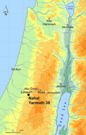
Munhata is one of the particularly important, but still surprisingly under-published, Neolithic sites of northern Israel. It captures an unusual moment in the development of village architecture: rectangular PPNB buildings, circular courtyard architecture, craft installations, hunting, plant processing, figurines, and an apparent break in occupation before the later Yarmukian pottery tradition. It is an excellent example of architecture in response to technology, ecology and society.
Munhata really is a Pre-Pottery Neolithic B site
Its greatest significance may be that it shows that the transition toward farming villages was not a simple story of “round huts to rectangular houses to agriculture.” Munhata contains a much more complicated mixture of sedentary village life, hunting, plant processing, possible caprine management, communal architecture and changing building forms.
It is located in the Jordan Rift Valley of northern Israel, approximately 15 km south of the Sea of Galilee (Lake Kinneret), and less than 1 km from the Jordan River. It lies at approximately 215 m below present sea level, on a broad alluvial fan at the outlet of the perennial Nahal Tabor (Tabor Stream). (Perrot 1964; recent synthesis in Changing Systems.)
Its approximate coordinates are: 32°36′ N, 35°33′ E
Jean Perrot described the location as a natural east–west passage: the Jordan could be crossed here, while routes connected Galilee with the Transjordanian valleys of the Yarmouk and Wadi al-‘Arab. (Perrot 1964.)
Munhata occupied a low, warm Jordan Valley environment, rather than the cooler uplands of Upper Galilee
The immediate geological setting includes alluvial clay, marl, soft chalk, with nearby limestone, basalt and access to Eocene formations.
The vegetation has been characterized as part of a Mediterranean savanoid zone, including Ziziphus lotus communities and associated shrubs. (Baruch 1986; summarized in Changing Systems.)
The perennial Nahal Tabor and nearby Jordan River would have made water availability unusually dependable
This is important architecturally: Munhata was not simply a village in a dry desert-like valley. It was a settlement exploiting a mosaic of riverine, wetland, alluvial and upland environments.
The sites sequence is:
Level Cultural period
6–4/3 Pre-Pottery Neolithic B
hiatus abandonment
2b Yarmukian Pottery Neolithic
2a Wadi Rabah / later Pottery Neolithic–Early Chalcolithic
later additional occupation and burials
There is some variation in how individual levels are subdivided in older publications, which is one reason Munhata’s chronology has been difficult to reconstruct.
Jean Perrot identified three major occupation periods separated by abandonment episodes. The first was the aceramic occupation represented by levels 3–6; after a break, level 2 was established; later activity belonged to the subsequent pottery phases. The later archival/research work identifies PPNB occupation, a substantial hiatus, Yarmukian occupation and Wadi Rabah occupation
The important archaeological observation is that, the PPNB settlement was sufficiently abandoned for its uppermost architecture to disappear, beneath accumulated sediment, before the later inhabitants returned
Perrot specifically noted that the earlier structures were no longer visible at ground surface when level 2 was established.
It is surprisingly complicated if they farmed wheat or barley
There is evidence for plant processing: sickle blades, querns, grinding stones, pestles and mortars. But the older interpretation was that the economy was based substantially on wild resources and hunting, rather than being a fully agricultural economy.
The presence of a sickle does not automatically mean domesticated wheat was being harvested. A sickle can harvest different things: wild cereals, cultivated cereals, reeds and grasses. And, likewise, grinding stones demonstrate processing, not necessarily cultivation.
Caprines were present
But whether they were domestic sheep/goats is a much more difficult question. Zooarchaeological work has traditionally interpreted Munhata’s economy as involving: caprines, gazelle and other hunted animals. An important older assessment found that the Munhata caprines were not morphologically distinguishable from wild populations, making secure domestication difficult to demonstrate.
Architecture
The PPNB buildings incorporated: stone foundations, mudbrick walls, plastered floors, paved floors, hearths, benches/platforms, niches and outdoor working surfaces. The combination of stone foundation + mudbrick superstructure + plaster places Munhata firmly within the architectural tradition of the PPNB.
The site is particularly interesting because it didn’t use only one house form
Buildings were rectangular. Some were multi-roomed.

One unusual structure contained a central circular courtyard with rooms radiating around it
This is one of Munhata’s most distinctive architectural features. Recent synthesis explicitly describes it as both domestic and communal architecture. The circular courtyard structure could have accommodated activities involving more than one household. Perhaps a communal or multifunctional architectural complex rather than a clearly identifiable temple.
Another remarkable feature was a large platform with channels cut into it, associated with a pebble-lined trough
This has been interpreted as a possible craft installation. For an architectural historian, it is extremely interesting because it suggests the village’s architecture was not simply: house = sleeping + cooking. Instead, architecture was already organizing: domestic activities, food processing, craft production, communal activities, circulation and outdoor work. That is exactly the kind of evidence that helps explain how Neolithic architecture became a social technology.
Ground-stone research identified a grille-like structure with parallel walls, which has been interpreted as possibly representing the foundations of a granary
If true, it provides an important link between: architecture, food processing, storage and social organization.
The archaeological record is overwhelmingly mineral: stone, mudbrick, plaster and clay
There is no famous assemblage of preserved wooden beams or carpentry comparable to waterlogged Neolithic sites elsewhere. Wood and reeds may nevertheless have been incorporated into roofing and other perishable construction components; the absence of preserved wood does not mean that the buildings contained no timber.
Building design included: centrally positioned hearths, stone-lined hearths, benches, plastered surfaces, niches and working areas
This is significant because it shows that the house was already being designed as a set of specialized spaces, rather than as a single undifferentiated shelter. The northern walls of some buildings contained plastered niches, with a comparable architectural feature known from Jericho.
Avi Gopher published a major study on lithic assemblage: The Flint Assemblages of Munhata (Israel): Final Report (1989)
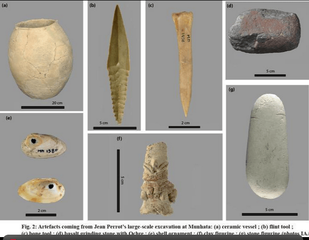
It contained: arrowheads, sickle blades, blades, scrapers, borers, burins and other chipped-stone tools. Large numbers of finely denticulated sickle blades were recovered.
The lithic assemblage has also been studied from a raw-material procurement perspective by Christophe Delage, whose work examined the availability, geological nature and exploitation of chert through the Munhata sequence.
Obsidian occurs
Munhata was minimally participating in the broader Neolithic exchange network that moved obsidian across the Levant.
Projectile technology was found
Arrowheads included: tanged forms, winged forms, pointed-shoulder forms, leaf-shaped forms, diamond-shaped forms and notched examples. These are important because they reinforce the evidence that hunting was a major part of the Munhata economy.
Munhata produced both: anthropomorphic figurines and zoomorphic figurines
They have been comprehensively studied by Yosef Garfinkel in: Garfinkel, Y. (1995), Human and Animal Figurines of Munhata.
Some are made from: clay, stone, limestone and greenstone. The figures include representations emphasizing: faces, eyes, noses, sexual characteristics; and, animals, including horned forms. This gives Munhata an important symbolic dimension.
Munhata also produced a particularly strange group of cylindrical objects
At the Yarmukian level there were: approximately 16 cylindrical clay objects and four similar stone objects. They were once interpreted as phallic/cultic objects. A later study by Naama Goren-Inbar, Michael Freikman, Yosef Garfinkel, Nigel Goring-Morris and Leore Grosman proposed something much more practical: They may have been components of fire-drills. In other words, what looked like ritual phalli may instead have been technological components of a fire-making system. That is a fantastic example of why archaeological interpretation changes when objects are reconsidered technologically.
Munhata’s ground-stone assemblage was studied extensively
Avi Gopher & Estelle Orrelle (1995) report includes: grinding stones, mortars, pestles, polishers, grooved stones, perforated stones, axes, ornaments, weights and figurines. Some objects were clearly utilitarian, while others were more difficult to interpret. This assemblage is particularly valuable for understanding the physical work performed inside and around the buildings.
Munhata also produced perforated objects sometimes described as mace heads.
The Munhata landscape has changed dramatically since nearly 9 thousand years ago
During the Neolithic, the landscape around the settlement contained: perennial waters, alluvial wetlands, riverine environments, grassland/savanoid vegetation and access to upland woodland. Today the Jordan Valley is hotter, more heavily cultivated, more engineered, substantially altered by irrigation and water extraction and surrounded by landscapes affected by intensive agriculture and grazing.
The Munhata site is important. It is especially valuable because it complicates the usual architectural story. Sedentary settlement, rectangular buildings, plastered interiors, specialized rooms, outdoor workspaces, circular courtyard architecture, communal organization, abandonment, later return, pottery villages and increasingly standardized rectangular architecture. And, the economic picture is equally complicated: hunting + plant processing + possible early animal management + exchange + craft production. It is another excellent example as architecture for a response to ecology, technology and social organization.
References: Perrot, J. (1964). Les deux premières campagnes de fouilles à Munhatta (1962–1963): Premiers résultats. Syria, 41, 323–345.
Perrot, J. (1966). La troisième campagne de fouilles à Munhata (1964). Syria, 43, 49–63. Lithics
Gopher, A. (1989). The Flint Assemblages of Munhata (Israel): Final Report. Paris: Association Paléorient.
Delage, C. (2007). “Three Periods, Three Patterns of Chert Exploitation in the Neolithic of Munhata (Central Jordan Valley, Israel).” In C. Delage (ed.), Chert Availability and Prehistoric Exploitation in the Near East, pp. 358–403. Oxford: Archaeopress.
Gopher, A., & Orrelle, E. (1995). The Ground Stone Assemblages of Munhata: A Neolithic Site in the Jordan Valley, Israel: A Report. Paris: Association Paléorient.
Garfinkel, Y. (1995). Human and Animal Figurines of Munhata (Israel). Paris: Association Paléorient.
Goren-Inbar, N., Freikman, M., Garfinkel, Y., Goring-Morris, N. A., & Grosman, L. (2012). “The Earliest Matches.” PLoS ONE, 7(8), e42213.
Vieugué, J., & Eirikh-Rose, A. Munhata and the Second Neolithic Revolution in the Near East. Shelby White and Leon Levy Program for Archaeological Publications, Harvard.
Hazan, N., Stein, M., Agnon, A., Marco, S., Nadel, D., Negendank, J. F. W., et al. (2005). “The Late Quaternary Limnological History of Lake Kinneret, Israel.” Quaternary Research, 63, 60–77.
Leave a Reply