<home # start here # guides # builds # services # shop # about # categories>
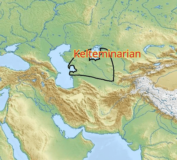
Imagine a landscape very different from the one we see today. There is a huge inland sea to the north. The Amu Darya spreads into a complicated delta of channels, lakes, marshes and reed beds. The Kyzylkum and Karakum deserts surround the wetland. Fish are abundant. Wild animals come to drink. Reeds grow along the water. And, a group of people builds an enormous oval house from wooden poles, reeds, branches, hides and earth. Inside is a large central hearth. Around it are people making pottery, shaping flint, repairing fishing equipment, preparing food and working bone. This is the world of the Kelteminar culture.
Kelteminar is one of the most interesting Neolithic traditions of Central Asia because it does not fit the familiar image of the “Neolithic Revolution”
These people had pottery. They made polished stone axes. They built substantial houses. They fished, hunted and gathered. But for much of the early Kelteminar sequence there is little or no convincing evidence for crop agriculture or established livestock herding.
Their Neolithic was therefore fundamentally a water-and-wild-resource adaptation, rather than a wheat-and-sheep farming economy. [1][3]
Kelteminar developed across a very large area of Central Asia
Its main distribution included the Amu Darya delta, ancient Khorezm, the lower Zeravshan, the Kyzylkum, areas around the Aral Sea, parts of western Kazakhstan, ancient river channels and lake basins, and the Uzboy/Sarykamysh region. The culture is especially strongly associated with the region south and southeast of the Aral Sea. [1][4]
Today, much of this territory lies in Uzbekistan, Kazakhstan, and Turkmenistan. It is not central European Russia. Nor primarily a Russian archaeological culture in modern geographical terms. However, this is an important part of the wider Eurasian archaeological world, and Kelteminar material has connections extending northward toward the Urals, western Siberia and the lower Ob region. [4][5]
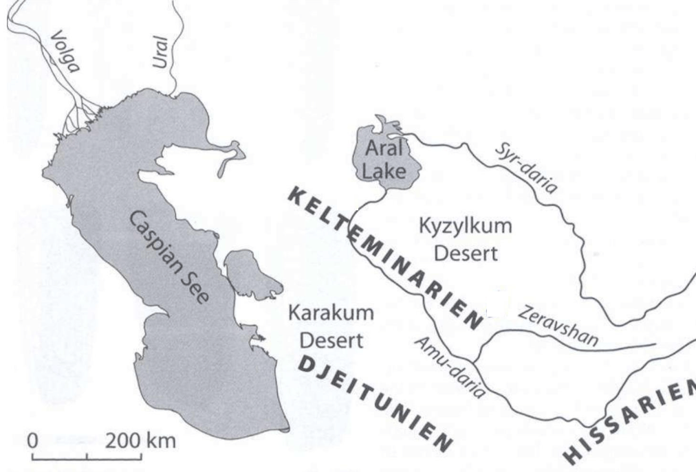
The Aral Sea was one of the defining geographical features of the Kelteminar world
But there is a major archaeological warning: The modern Aral Sea is not the Neolithic Aral Sea. The Aral basin has undergone substantial changes in water level, shoreline and drainage through the Holocene. The present-day Aral Sea is largely the product of a much more recent hydrological history, and its modern dramatic shrinkage is primarily anthropogenic. During the Neolithic, however, the region contained a much more complicated mosaic of lakes, river channels, marshes, delta environments and periodically flooded depressions. The archaeological record shows Kelteminar settlements repeatedly associated with these former water environments. [6][7]
The great river of the Kelteminar world was the: Amu Darya
This river rises far to the east in the Pamir region and eventually reaches the Aral basin. Today it is one of Central Asia’s great rivers. In the Neolithic, its channels were not necessarily in exactly the same places as today. The Akcha Darya was an ancient distributary of the Amu Darya and became particularly important for Kelteminar settlement. Dzhanbas-4 was situated in this ancient deltaic landscape. [1][6]
This makes the geography fascinating. Pamir mountains to Amu Darya to delta to lakes and channels to Aral basin to Kelteminar settlements
Was the Syr Darya involved?
The relationship is broader than simply saying that Kelteminar lived “on the Syr Darya. Kelteminar material is known from areas around the lower Syr Darya and its ancient channels as well as the Amu Darya system. The culture therefore occupied a broad Aral Sea–Central Asian water network, rather than one single river valley. [1][8]
Mountains
Kelteminar was not a mountain culture. Its principal settlements were overwhelmingly associated with lowlands, deserts, river deltas and former lake basins. But mountains were not terribly far away in the larger geographical system. Important mountain regions included Sultan-Uizdag / Sultan-Uiz Mountains. These rise near ancient Khorezm and the Amu Darya delta.
Kopet Dag. Farther south, along the Turkmenistan–Iran frontier.
Kyzylkum uplands. Low mountains and rocky ranges occur within and around the Kyzylkum. And,
Tian Shan and Pamir. Much farther east, forming the great mountain sources of the Central Asian rivers.
The contrast is striking: The people lived in the lowlands, but their water came from mountains thousands of kilometres away.
How far from Lake Baikal? Very
Depending upon the exact points measured, the Kelteminar heartland around the Aral Sea is approximately 1,800–2,200 km from Lake Baikal. By prehistoric travel routes, the distance would have been substantially greater.So Kelteminar was not a Baikal culture. Nevertheless, the archaeological world to the north and east was connected through broad steppe and river corridors. Stone-tool similarities and pottery traditions demonstrate that Central Asian Neolithic communities participated in wider networks reaching toward the Urals, western Siberia and northern Eurasia. [4][5]
The Kelteminar heartland is outside modern Russia
The northern edge of its interaction sphere, however, approached regions that are now within Russia and Kazakhstan. The nearest major Russian archaeological zones include southern Ural region, Trans-Urals, lower Volga and western Siberia. This makes Kelteminar very useful when studying the Neolithic of Eurasia as a connected system rather than as modern national archaeological boxes. The Amu Darya does not stop being important because a modern international boundary appears on a map.
Dzhanbas-4: the famous house
The architectural star of Kelteminar is Dzhanbas-4. This site was excavated during the Soviet-era Khorezm Archaeological and Ethnographic Expedition. The excavation revealed an exceptionally large dwelling. Earlier publications describe the structure as approximately: 24 × 17 metres. With an area of roughly 290 m².
Tolstov estimated that it could accommodate approximately 100–125 people. [9][10]
That is enormous by Neolithic standards. It is one of the reasons Dzhanbas-4 is so important.
Was it a subterranean hut?
Not in the same sense as the deep semi-subterranean houses at some Lower Volga sites. The classic Dzhanbas-4 structure is better understood as a:large oval ground-level or slightly excavated frame dwelling. The terminology in older Russian literature can be confusing because “semi-dugout” is sometimes used broadly. The architectural evidence points toward a large timber framework, rather than a deeply excavated pit-house. [1][9] This distinction matters. Kelteminar architecture was essentially post, frame and lightweight roof/wall covering.
The timber frame
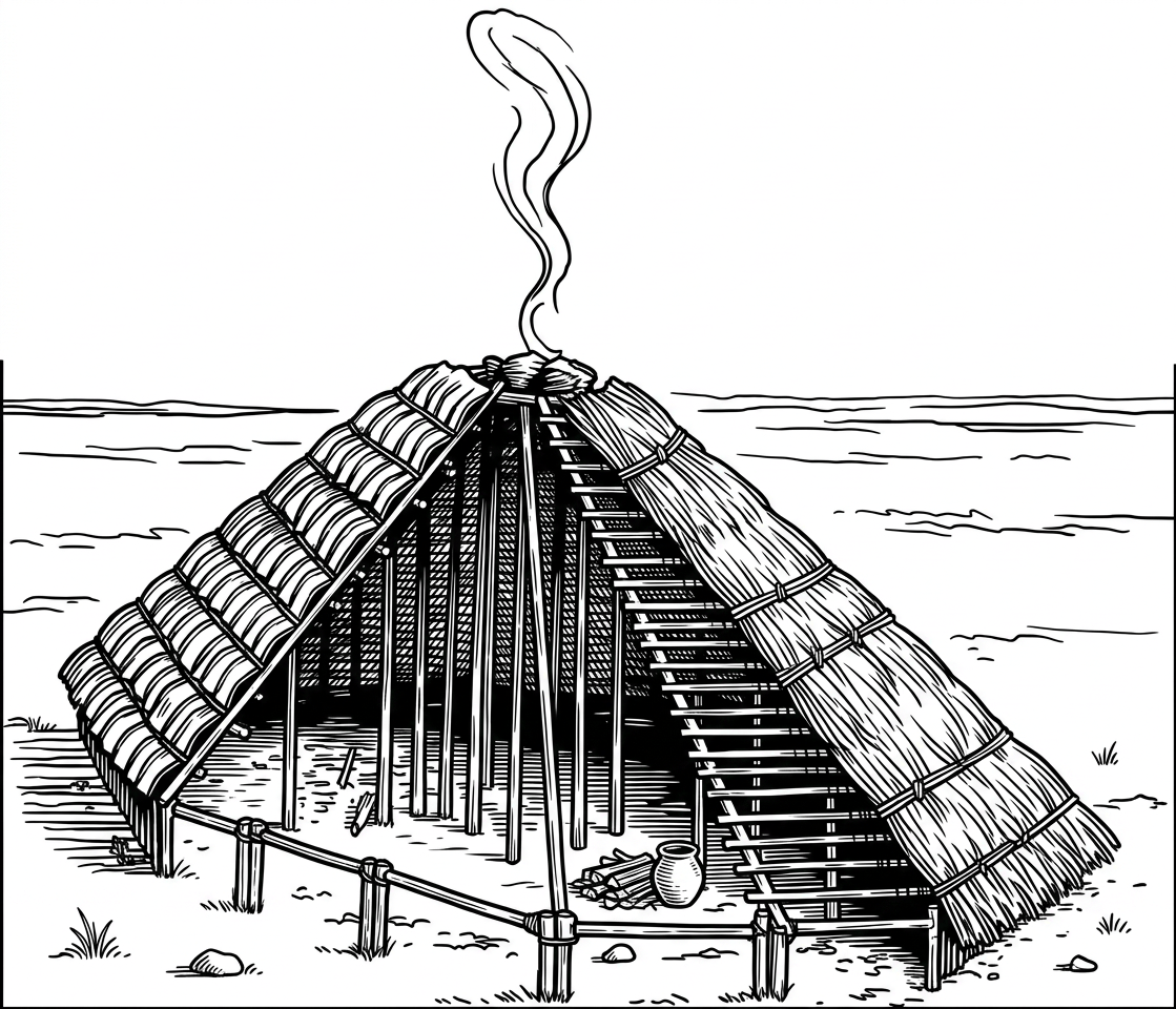
The building was supported by numerous wooden posts. The structure was approximately oval. A large number of posts formed the framework. The roof was probably supported by converging poles and beams. The covering could include reeds, branches, plant material and animal hides. This is an architecture perfectly suited to the environment. There was no need to manufacture enormous quantities of mudbrick. Instead wood, reed, brush and hide. Could create a surprisingly large shelter.
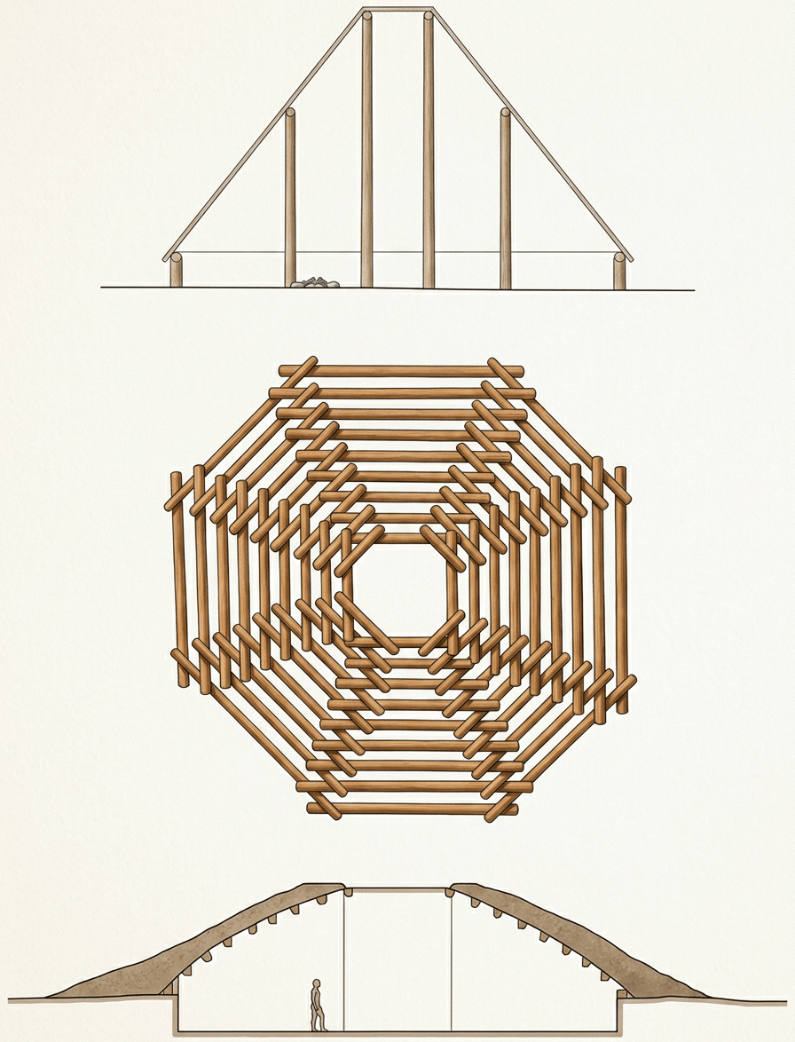
A giant Neolithic tent-house
One useful way to visualize Dzhanbas-4 is as a cross between a giant communal tent, and a timber-framed house. It was much larger and more permanent than an ordinary camping shelter. But it remained lightweight compared with the mudbrick architecture developing farther south. The building therefore sits between mobile and permanent architecture.
Reeds were an architectural material
This is one of the great environmental lessons of Kelteminar. The Amu Darya delta produced enormous quantities of reeds. Reeds could become roofing, wall coverings, screens, mats, fuel, baskets and fishing equipment. The landscape therefore supplied much of the building system. Instead of importing a construction material, people harvested the riverbank. A perfect example of architecture as an expression of ecology.
Mudbrick? Not the main technology
This distinguishes it strongly from: southern Turkmenistan’s Jeitun culture; and, later Bronze Age Central Asian settlements like Mesopotamia. Mud and earth may have been used locally, particularly in floors or structural contexts, but the defining architecture at Dzhanbas-4 is light timber/reed construction, not standardized mudbrick. [1][3]
The roof
The roof was probably the most important part of the building. A large central or longitudinal structural system supported the roof. Reeds and branches could provide an insulating waterproof layer. The result would resemble an enormous: oval reed-roofed hall. The exact roof geometry remains partly reconstructive because organic roofing material rarely survives. So illustrations should distinguish excavated post pattern from reconstructed roof.
The central hearth
Here the architecture becomes particularly interesting. Dzhanbas-4 contained a large central hearth approximately 1.2 metres across. It was located on a thick layer of sand. Prolonged burning reddened the underlying material to a considerable depth.
Remarkably, the central hearth reportedly lacked the normal concentration of household debris found around ordinary cooking fires. [11] Tolstov and later interpreters therefore considered it potentially ritual or ceremonial. This is one of the most intriguing features of the entire settlement.
Was this a fire shrine?
There is no surviving sign saying: “FIRE TEMPLE.” The interpretation is archaeological. The central hearth appears unusual because it lacks the ordinary domestic debris expected from a cooking fire. Therefore one possibility is ceremonial fire. But it could also have been a special communal hearth whose function we do not fully understand. It is potentially ritual or communal central hearth.
Ordinary hearths were different
An especially interesting feature is that many ordinary household hearths were located outside the main dwelling. A modern house might put the kitchen inside. Dzhanbas-4 apparently did something different. The central fire may have had a symbolic or communal role while practical cooking fires operated elsewhere. This creates an intriguing division inside, community / central fire and outside, everyday cooking [11]
Fifty-six hearths. At Dzhanbas-4, researchers have reported 56 hearths associated with the settlement. [11]
It suggests that fire was everywhere around the building. Imagine the settlement at night. Dozens of small fires, a huge central structure, smoke drifting through the reeds, people preparing food, fish being processed, hides being worked and pottery vessels around cooking areas. This would have been a very busy place.
A communal building? Possible
The size of Dzhanbas-4 is remarkable. If Tolstov’s estimate of 100–125 people is approximately correct, this was not an ordinary nuclear-family house. [9][10] It may have been: a large household, an extended family residence, a clan building, a communal dwelling and a seasonal aggregation centre. The safest interpretation is a very large communal or corporate dwelling. The architecture suggests that social organization was substantially larger than the modern nuclear household.
What did the settlement look like? It was not a city
There was no streets, stone walls, towers, monumental temples or mudbrick houses. Instead, imagine one enormous dwelling. Surrounded by hearths, work areas, refuse, pottery, animal remains, fishing equipment and stone tools. Other Kelteminar sites show smaller or lighter occupations. The settlement system was therefore probably seasonal and flexible.
A water-based economy
This is perhaps the single most important point about Kelteminar. The economy was strongly based on: fishing, hunting and gathering. Fish, aquatic environments and river/lake resources were central to settlement location. The people were repeatedly drawn to ancient channels, lake margins, deltas, wetlands and river terraces. [1][4] Kelteminar can therefore be described as a Neolithic aquatic adaptation.
Fish remains are important
Fishing equipment includes evidence such as net weights, bone implements, harpoon-like points and fish-processing tools. A recent study of northern Aral sites identified a stone net weight, strengthening the archaeological case for fishing. [4] This is exactly what we would expect from a population living in a river-and-lake environment.
Did they build boats? We need to separate reasonable inference from archaeological proof
There are no famous surviving Kelteminar boats. Wood is exceptionally unlikely to survive in most of these archaeological environments. But the environment and economy make water transport plausible. If people were exploiting large rivers, lakes, delta channels and wetlands. Then some form of watercraft would have been highly advantageous. Technologies could have included dugout canoes, reed boats, bundles of reeds or simple rafts. But these remain reconstructions, not securely excavated objects.
Reed boats are especially plausible
The raw material was everywhere. Reeds could be bundled into buoyant structures. Central Asian peoples historically used reed watercraft, making the technology environmentally plausible. But archaeological evidence for specifically Neolithic Kelteminar reed boats is presently insufficient to claim certainty.
Hunting
Fishing was only half the story. Kelteminar people also hunted extensively. Their prey included a mixture of wild cattle/aurochs, deer, wild ass, gazelle, boar, smaller mammals, birds and waterfowl. The exact proportions varied between sites and periods. This was an extraordinarily productive landscape because river and desert ecosystems overlapped.
What did they eat?
Their diet probably consisted primarily of: fish, wild game, birds, gathered plants and nuts/seeds/roots where locally available. At different sites, the balance could change. Near a lake fish and waterfowl. Near steppe: gazelle, wild cattle and other game. Near river margins fish, birds and plants. The flexibility of this diet was probably one reason the culture persisted for thousands of years.
Wheat and barley?
This is complicated. For the classic early Kelteminar economy, there is no good evidence that wheat and barley cultivation was the main food system. The traditional interpretation is overwhelmingly: hunting, fishing and gathering. However, recent research is changing our picture of Central Asian food economies. A 2025 study of the Toda cave in southern Uzbekistan reported approximately 9,000-year-old barley consumption, associated with sickle blades and grinding stones. [12] That is extremely important—but it should not automatically be attributed to the classic Dzhanbas-4 Kelteminar economy. It tells us that early Central Asian populations were interacting with cereals considerably earlier than the old textbook model suggested.
Domesticated fruits?
There is no strong evidence that Kelteminar communities cultivated: apples, pears, apricots, pomegranates and grapes. Wild fruits and seeds may have been gathered. But these were not orchard farmers. The contrast with Jeitun farther south is crucial.
Jeitun versus Kelteminar
At roughly the same broad period Jeitun had: mudbrick houses, agriculture, wheat/barley, sheep/goats, and permanent villages. While Kelteminar had large lightweight houses, fishing, hunting, gathering, pottery and microlithic stone tools. This is one of the best demonstrations that “Neolithic” did not mean “farmer.” [3]
Animals
The evidence for domesticated animals is complicated. Older archaeological summaries often describe Kelteminar as essentially a hunter-fisher society without domesticated animals. More recent work suggests that some later Kelteminar-associated populations did have domestic animals. At Ayakagytma, zooarchaeological evidence indicates cattle and other domesticates, while later phases may have involved increasingly important camel herding. [13] A study of the site found a dramatic shift after approximately 4000 cal BCE, with camel remains becoming dominant and interpreted as evidence of an adaptation to increasing aridity. [13] This is extremely important. Kelteminar was not one unchanging economic system.
The camel problem
The possibility of early camel domestication is fascinating—but controversial. Some researchers interpret the Ayakagytma evidence as suggesting early camel management and perhaps milking. Others remain cautious. The safest statement is: Later Kelteminar-associated communities may have incorporated domestic livestock, including possibly camels, as dry conditions increased [13]
Flint was extremely important
Lithic technology included blades, flakes, microliths, geometric pieces, projectile points, scrapers, axes and cutting tools. The culture is especially famous for its lamellar/microlithic flint technology. [1][4]
Flint mining
This is another fascinating feature. The Great Russian Encyclopedia notes evidence for flint extraction pits/mines and stone-working workshops, including specialized micro-drills. [14] That means people were not simply picking up random stones. They knew where the good raw material was, and how to extract it. That is a form of prehistoric resource engineering.
Turquoise
Now we reach something much more interesting. The Kyzylkum region contains turquoise deposits, and prehistoric exploitation of turquoise is associated with the wider Kelteminar archaeological world. [14][15] Turquoise was potentially valuable as ornament, status material
and exchange item. This gives us evidence that Kelteminar was not isolated. The desert itself contained resources worth collecting and moving.
Copper?
Copper becomes increasingly important in later Central Asian prehistoric contexts. However, copper is not the defining material of early Kelteminar. Major technologies of the classic Kelteminar horizon were stone, bone, pottery and organic materials.
Gold?
No major gold assemblage defines Kelteminar. Prestige objects were more likely to involve shells, turquoise, decorated bone, animal teeth, unusual stone and carefully manufactured tools.
Shell ornaments
Shells were used both as ornaments and in ceramic technology/material mixtures in some Central Asian contexts. Shell beads and ornaments are especially interesting because they could signal movement between different ecological zones. A shell from a distant water body can become jewellery, trade evidence and social identity.
Burials are known from Kelteminar-associated sites
Graves have produced stone tools, flint, quartz and other objects. The mortuary evidence demonstrates that tools could accompany the dead. [2] But Kelteminar does not have a famous cemetery on the scale of later Khvalynsk or Varna.
Ochre is known in prehistoric Central Asia
It is not the defining architectural feature of Kelteminar in the way that red-ochre floors are at Varfolomeevka. Kelteminar had reed-and-timber architecture. Sakhtysh had forest timber architecture. And, there were others. Each expresses a different environmental and social system.
Weapons
Weapons include: microlithic projectile points, notched arrowheads, bone points and hunting implements. The distinctive notched-base projectile points are particularly characteristic of Kelteminar material. [16] These are the tools of a hunting society.
Did they trade?
Kelteminar material shows relationships with Jeitun, southern Central Asia, northern Caspian, Ural regions, western Siberia and lower Ob. [4][5] The distribution of technological and ceramic similarities is too broad to regard the population as isolated.
A connection could be better understood as part of a larger chain of cultural transmission. Like that ideas and technologies could move Anatolia / Iran to southern Central Asia, to Amu Darya to Aral basin, and to northern steppe. Without the same individual travelling the entire distance. The difference between direct trade, and network transmission.
Mountains and trade
The mountains were enormously important indirectly. The Central Asian rivers originated in: Pamirs, Tian Shan and Hindu Kush-related highlands. Mountain regions also supplied stone, minerals, metals, turquoise and other exotic materials. Kelteminar therefore occupied the lowland end of a much larger mountain-to-delta resource system.
Climate: the key to the whole story
The Kelteminar world developed during a period of major Holocene environmental change. Around the sixth millennium BCE, the Central Asian lowlands experienced a relatively moist phase, often associated with the Lyavlyakan/Liavlyakan pluvial. Water availability increased in portions of the arid zone. Lakes expanded. River channels became more active. Wetlands expanded. That created exactly the environment a fishing-and-hunting population needed. [17]
The desert was not always today’s desert
This is perhaps the most important environmental lesson. When we look at the modern Karakum, or Kyzylkum. We imagine sand. But the Neolithic landscape could contain lakes, reeds, channels, grassland and wetlands. Some archaeological sites are associated with former lakes that no longer exist. The desert therefore preserves the ghost of a much wetter prehistoric landscape.
The Aral itself changed
The Aral basin has experienced major fluctuations through the Holocene. Research indicates that its history is closely linked to: Amu Darya discharge, Syr Darya discharge, climate, evaporation and drainage changes. [6][7] The precise configuration of the Aral Sea during the Kelteminar period remains an active research subject.
Kelteminar occupied the Aral Sea basin and its surrounding delta/lake systems
Why did Kelteminar change?
Climate appears to have been one important factor. The Central Asian climate became progressively more arid during parts of the later Holocene. As water availability changed lakes shrank, river channels shifted, wetlands contracted, grasslands changed and animal populations moved. A fishing economy cannot simply continue unchanged if its lakes disappear.
From fishing to herding
This is where the later Kelteminar story becomes especially interesting. At some sites, increasing aridity appears to coincide with greater dependence upon domestic animals and eventually herding. At Ayakagytma, research suggests a transition toward cattle and potentially camel management associated with increasingly dry conditions. [13]
In other words: climate change may have helped push some communities from aquatic hunting economies toward mobile pastoralism. That is a major story in Central Asian prehistory.
Was Kelteminar abandoned?
Not in a single catastrophic event. The Kelteminar tradition gradually changed. Different regions were occupied at different times. Some settlements were abandoned. Others were reused. New economic systems emerged. Eventually the archaeological cultures of the region became increasingly pastoral and agricultural. So Kelteminar did not simply disappear. Its world transformed.
A climate-adaptation machine
This makes Kelteminar especially valuable for modern architectural thinking. Its buildings were light, repairable, locally sourced, seasonally adaptable, made from renewable materials and suited to water-edge environments. If a settlement moved the house could potentially be rebuilt. If reeds became unavailable the construction system could change. f water moved the settlement could move. This is architecture designed around mobility and environmental uncertainty.
The 290-square-metre lesson
The enormous Dzhanbas-4 house presents an interesting contradiction. The building was large but lightweight.
Modern construction often associates size with massive quantities of material. Kelteminar shows another possibility large communal space does not necessarily require heavy architecture. A huge structure can be made from posts, reeds, branches and hides. That is a remarkable lesson in material efficiency.
Architecture without masonry
Compare three Central Asian Neolithic solutions. Jeitun. mudbrick. Kelteminar. Timber and reed. And, Hissar. Mud/light surface structures. The architecture changes because the environments change. Where good building earth and agriculture support permanent settlement mudbrick becomes attractive. Where reeds, water and mobility dominate. Lightweight frame architecture becomes attractive. Architecture is therefore not just culture. It is climate, resources, economy and social organization.
The house as a community
The most provocative feature of Dzhanbas-4 is its scale. If the 100–125-person estimate is even approximately correct, the building was not merely a shelter. It was a social institution. People had to organize construction, food, fishing, hunting, fire, pottery, waste and maintenance.. A building that large requires communication. That makes Dzhanbas-4 an excellent prehistoric case study in architecture as communication.
No architect required
There is no evidence of an architect in the modern professional sense. But somebody had to know how many posts were needed, where they went, how the roof carried loads, how the entrance worked, how smoke escaped, how reeds were attached and how the structure was repaired. That knowledge was probably embedded in the community. It was craft knowledge, memory and repetition.
A building manual without writing
The Kelteminar house is therefore a kind of unwritten instruction manual.
A child watching adults could learn cut post, set post, tie frame, add roof supports, attach reeds, make hearth, repair when damaged. The building itself transmitted knowledge between generations.
The water economy
Kelteminar is especially important because it reminds us that early sedentism did not require agriculture. A community can become relatively settled because fish are predictable, water is predictable, game concentrates near water, plants grow near water and reeds provide building materials. Agriculture is only one way to make a place worth staying. A productive wetland can do the same thing.
The great irony is that today the Aral region is famous for environmental disaster
Kelteminar shows us the opposite: a prehistoric civilization adapted to a water-rich Aral landscape. Thousands of years later, the same broad region became one of the world’s most famous examples of environmental degradation. That makes Kelteminar an extraordinarily powerful case study for environmental architecture. The lesson is not “Ancient people lived sustainably.” That would be too simplistic. The better lesson is: Ancient people designed their settlement systems around the water that the landscape actually supplied.
If we had to describe the culture in one sentence:
Kelteminar was a broad Central Asian Neolithic tradition of hunter-fisher-gatherers who occupied the river, lake and delta environments of the Aral basin and built unusually large lightweight timber-and-reed dwellings.
The architectural formula Dzhanbas-4
WATER. Amu Darya + lakes + channels;
MATERIAL. Reed + timber + brush + hide;
BUILDING. Large oval communal frame;
FIRE. Central special hearth + numerous domestic fires;
FOOD. Fish + game + gathered plants;
TECHNOLOGY: flint + bone + pottery;
SOCIAL SYSTEM: large cooperative household/community;
CLIMATE: wet phase to increasing aridity; and
ADAPTATION: mobility + changing subsistence + eventual pastoralism.
That is an extraordinarily complete architectural system.
Kelteminar is not simply “the people who lived near the Aral Sea.”
It is a case study in how humans can create a substantial settlement without mudbrick cities, agricultural fields, metal tools, stone monuments, or permanent masonry architecture. Their engineering solution was different. They used water, reeds, wood, fire, pottery, flint, animal knowledge, and collective labour. The result was one of the most unusual Neolithic architectural traditions in Eurasia.
The great Dzhanbas-4 house demonstrates that a Neolithic building could be enormous without being massive, communal without being monumental, and sophisticated without relying upon agriculture. In that sense, Kelteminar offers a particularly powerful definition of architecture. Architecture begins not when people build permanent walls, but when a community learns how to organize materials, fire, water, space and labour into a place where people can survive together.
References: [1] Vinogradov, A. V. (1981). Drevnie okhotniki i rybolovy sredneaziatskogo mezhdurech’ya [Ancient hunters and fishers of the Central Asian interfluve]. Moscow. This remains one of the fundamental syntheses of Kelteminar archaeology, including settlement, economy, ceramics and lithics.
[2] Dani, A. H., & Masson, V. M. (Eds.). (1992). History of Civilizations of Central Asia, Vol. 1: The Dawn of Civilization: Earliest Times to 700 B.C. UNESCO. This is a useful general scholarly synthesis for Central Asian Neolithic cultures and the Kelteminar tradition.
[3] Masson, V. M. (1971). Poselenie Dzheĭtun [The settlement of Jeitun]. Leningrad. Useful particularly for comparison with the contemporary agricultural Jeitun culture.
[4] Rakhimzhanova, S. Zh., Tusheva, Y. K., Aminova, R. N., Kurmaniyazov, Y. S., & Akkoshkarova, Z. T. (2025). “Genesis of Neolithic sites from the Aral Sea region.” L’Anthropologie, 129(2), 103369. DOI: 10.1016/j.anthro.2025.103369. Particularly valuable because it incorporates new archaeological material from the northwestern Aral region.
[5] Vinogradov, A. V. (1968/1981). Studies of the Neolithic hunters and fishers of the Central Asian interfluve. These works are important for the northern and eastern connections of Kelteminar technology.
[6] Boomer, I., Aladin, N., Plotnikov, I., & Whatley, R. (2000). “The palaeolimnology of the Aral Sea: a review.” Quaternary Science Reviews, 19, 1259–1270. DOI: 10.1016/S0277-3791(00)00002-0. This is an important background source for understanding the changing Aral basin and its relationship to the Amu Darya and Syr Darya.
[7] Boroffka, N., et al. (2006). “Archaeology and climate: Settlement and lake-level changes at the Aral Sea.” Geoarchaeology. DOI: 10.1002/gea.20135. The study connects archaeological settlement changes with Holocene lake-level/environmental fluctuations.
[8] Lioubimtseva, E., et al. (2005). “A review of the Holocene climate history of Central Asia.” Journal of Arid Environments, 62, 285–308. This synthesis is useful for the Lyavlyakan pluvial/moist phase and subsequent drying of the Central Asian lowlands.
[9] Tolstov, S. P. (1948). Drevniy Khorezm [Ancient Khorezm]. Moscow. Tolstov led the Khorezm Archaeological and Ethnographic Expedition that discovered and investigated the Kelteminar sites, including Dzhanbas-4. The later architectural literature cites his original measurements and interpretation of the dwelling.
[10] Gulyamov, Ya. G. (1958). Research on prehistoric and early historic settlement in Uzbekistan. His work is particularly important for comparison with Darbazakir-1, another Kelteminar dwelling, where an approximately 81 m² oval structure with two concentric rows of posts was identified.
[11] Tolstov, S. P., 1948; subsequent Uzbek architectural studies. The Dzhanbas-4 central hearth, approximately 1.2 m across, was located on a thick sand layer and produced unusually intense burning; 56 additional hearths have been reported around the dwelling. The central fire’s unusual lack of ordinary domestic material has led researchers to propose a ritual/communal function.
[12] Recent archaeobotanical research, “9,000-year-old barley consumption in the foothills of Central Asia.” This is an important new qualification to the older picture of Central Asian Neolithic subsistence. Barley was identified at Toda cave in southern Uzbekistan alongside sickle blades and grinding stones. It should not, however, automatically be treated as evidence for cereal farming at Dzhanbas-4.
[13] Suska-Malawska, M., Kot, M., Gręzak, A., Mętrak, M., Khudjanazarov, M., & Szymczak, K. (2022). “Potential impact of Holocene climate changes on camel breeding practices of Neolithic pastoralists in the Central Asian drylands: A preliminary assessment.” The Holocene. The paper is especially important for Ayakagytma and the changing role of cattle, horses and potentially camels after approximately 4000 cal BCE.
[14] Большая российская энциклопедия [Great Russian Encyclopedia]. “Кельтеминарская культура” [Kelteminar Culture]. Particularly useful for the geographical distribution, chronology, flint extraction/mining, stone workshops and turquoise-related resources.
[15] Frachetti, M. D. and subsequent Central Asian archaeological syntheses. The wider Central Asian archaeological record demonstrates the significance of turquoise and other semi-precious stones in prehistoric exchange networks; the Kelteminar–Kyzylkum relationship is particularly important here.
[16] Korobkova, G. F. (1969). Orudiya truda i khozyaĭstvo neoliticheskikh plemyon Srednei Azii [Tools and economy of the Neolithic tribes of Central Asia]. Leningrad. A major source for Kelteminar stone-tool technology and subsistence. The archaeological synthesis identifies the lamellate flint industry, microliths and geometric forms as characteristic.
[17] Regional palaeoclimatic syntheses of Central Asia identify a relatively moist mid-Holocene phase approximately 6500–4900 years ago, followed by increasing aridity. These environmental changes are important for understanding why populations associated with Kelteminar could initially flourish in lake/delta environments and later adopt more mobile pastoral strategies.
Leave a Reply