<home # start here # guides # builds # services # shop # about # categories>
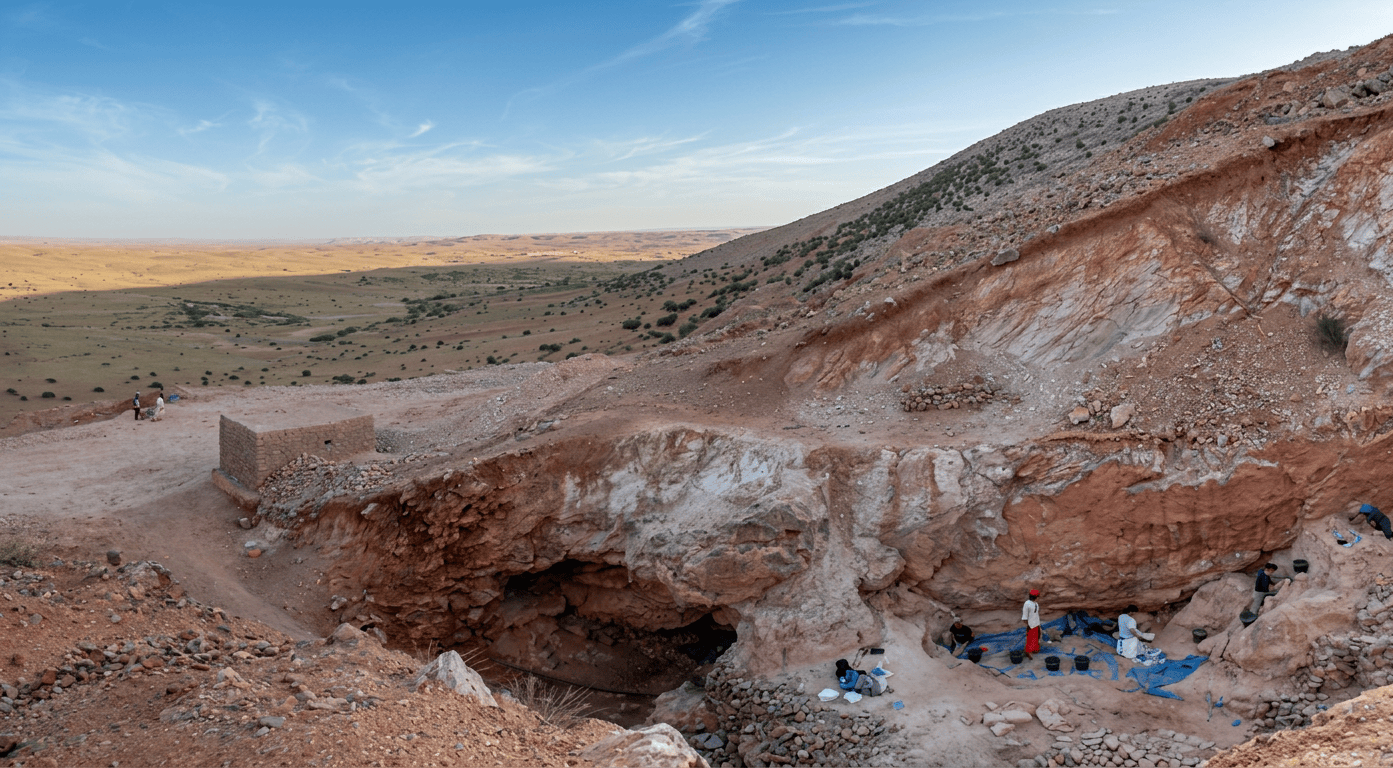
A 2017 dating gave the principal human bearing Middle Stone Age layer an age of 315 ± 34 thousand years. And, an independent uranium-series/ESR result of 286 ± 32 ka for a tooth. [1][2]
Where is it?
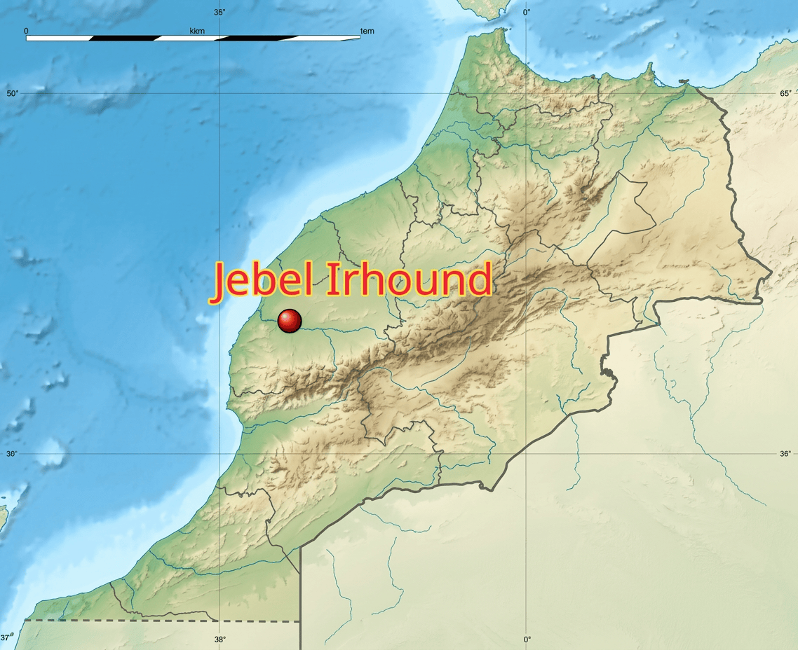
Jebel Irhoud is in western Morocco, in Youssoufia Province, about 50–70 km southeast of Safi, and roughly 100 km west of Marrakech. It lies at the western end of the ancient Jebilet Hercynian massif. [3] About 31.855° N, 8.873° W.
The archaeological locality sits on the eastern flank of a distinctive limestone massif reaching about 592 m above sea level. The mountain has a long north–south orientation and provides a remarkably broad view over the surrounding landscape. [3] This is therefore not a flat coastal site. It is a limestone mountain/cave landscape overlooking the western Moroccan plains.
Was it near the ocean?
Relatively near, but not coastal. Jebel Irhoud is approximately 50–70 km from the Atlantic coast, depending on which point on the coast is used. Safi, on the Atlantic, is the nearest major coastal city. [3][4] It can be discribed as an inland Atlantic-margin mountain site, rather than a coastal settlement.
Was there a river?
There was no major perennial river immediately beside the cave. The wider landscape belongs to the drainage system of the Tensift basin. The Oued Tensift runs south of the wider Ighoud area and eventually reaches the Atlantic at Souira Qedima. [5]
So the geographical system was approximately: Jebel Irhoud, local seasonal drainage, Tensift basin, Oued Tensift and Atlantic Ocean. This is different from a settlement such as Oued Beht, where the river is immediately beneath the archaeological settlement.
At Jebel Irhoud, the cave and the elevated limestone landscape were more important than a riverbank location.
Was there a lake?
There is no evidence for a large lake immediately beside Jebel Irhoud. Freshwater molluscs occur in the archaeological/faunal record, but that does not mean a lake was beside the cave. [6] The landscape appears to have contained seasonal and freshwater habitats within a broader grassland environment.
What mountains were nearby?
Jebel Irhoud is itself part of the western Jebilet, an ancient Hercynian/Paleozoic mountain massif. [3] The much larger High Atlas lies farther south. It is an interesting position. Jebilet mountains to western Moroccan plains to High Atlas farther south and Atlantic farther west. It is not an isolated mountain wilderness.
Was Jebel Irhoud inside a cave? Yes and its crucial
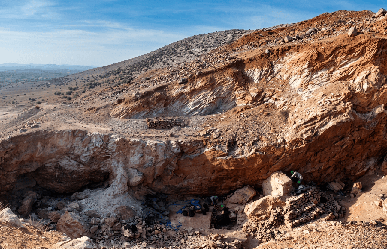
The modern archaeological excavation looks quite different from what the original inhabitants would have seen. The prehistoric site was originally a karstic limestone cave or partly enclosed “aven”/cavity. Over time, sediment filled the cavity. Later erosion, quarrying and especially twentieth-century barite mining destroyed much of the original cave roof. [3] The Moroccan researchers describe the prehistoric site as having potentially functioned as a cave or large vertical cavity into which sediments accumulated from above. [3] Approximately 8 m of Pleistocene deposits survived in parts of the cavity. [7] So when you see modern photographs of an open excavation, you are not looking at the original architecture.
The cave supplied: roof; walls; shade; wind protection; thermal buffering; and protected working space.
The people supplied: fire; tools; food processing; and organization of space. It was an early form of architecture as adaptation.
Did they have hearths? There is very strong evidence for fire use.
The archaeological deposits contain: heated flint; burned animal bone; charcoal/combustion evidence; and fire-affected archaeological material. Research on Middle Pleistocene fire specifically identifies Jebel Irhoud as having a strong anthropogenic fire signal around 300 ka. [8]
Did they cook? Very probably
The archaeological evidence includes: burned faunal remains; cut marks; percussion fractures; marrow extraction; and fire-affected stone. The dominant prey was gazelle, and the bones show human processing. [6][9]
Did they have pottery? No.
What did they eat? Wild game
Gazelle bones dominate the identified ungulate assemblage. [6][9] Other animals include evidence for: hartebeest/alcelaphine bovids; wildebeest; zebra/equids; wild cattle/bovids; wild boar; hare; porcupine; tortoise; and, other small animals. The older faunal collections also included carnivores: lion; leopard; hyena; jackal; and smaller cats. Some of these are environmental rather than food evidence.
The older faunal lists include Bos and other large bovids. [7]
Turtles? Yes, tortoises are represented
This is actually a useful reminder that the diet was broader than large-game hunting. UC Davis’ analysis identifies tortoises among the recovered fauna. [6]
Snails and shellfish? Freshwater molluscs occur in the faunal assemblage
Ostrich eggshell occurs
Researchers have been cautious about whether all of it represents deliberate human collection rather than natural accumulation. [6]
This was a hunter-gatherer society
Stone-tool technology
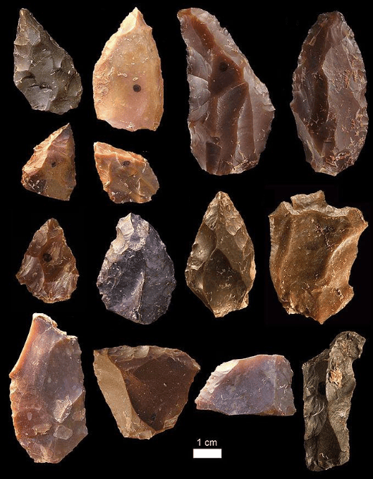
The site contains a Middle Stone Age lithic industry using prepared-core technology. The best-known technique is: Levallois technology Instead of simply smashing flakes off a rock, the knapper carefully prepared the shape of a core so that a predictable flake could be struck from it.
Assemblages included: Levallois flakes; points; scrapers; notches; denticulates; blades; retouched tools; and perforators and other forms. [3][10]
Flint trade
The major raw materials include: flint/chert, quartzite and quartz.
Most importantly, the high-quality flint appears to have been obtained from Jebel Khiyyat/Mekala, approximately 30 km south of Jebel Irhoud. [10]
No figurines, Obsidian, Jade, Gold or precious metals were found
The Jebel Irhoud evidence is spectacularly strong for fire, hunting and stone technology, but much weaker for formal symbolism.
Burials?
There is no securely demonstrated cemetery or intentional burial system at Jebel Irhoud. Human remains occur in the cave deposits, but their archaeological context was compromised to varying degrees by the old mining and excavation history, and researchers have not established a Taforalt-style mortuary complex.
Taforalt. Later hunter-gatherers and extensive cemetery
Jebel Irhoud. 315,000 years ago, human fossils and occupation debris, but no demonstrated cemetery

Was there a communal, ritual structure or findings?
No constructed communal building has been identified. But there is an interesting broader interpretation. The cave itself may have acted as a shared social space. People repeatedly: hunted; butchered; cooked; made tools; maintained fires; rested; and interacted. Thus the social architecture may have been: cave, fire, food, tools and people. It was communal without requiring a monumental building.
Was it an extreme environment?
The Middle Pleistocene environment around Jebel Irhoud appears to have been open grassland/savanna-like country, relatively dry but not desert. [3][7] Rodent evidence is especially useful here. The micromammal assemblage indicates: substantial grassland, relatively favorable conditions; and more moisture than some later North African environments. [12] The landscape therefore probably looked much more like open grassland, scattered trees/shrubs and rocky hills. Than modern desert.
What was the climate 300,000 years ago?
The site dates to Marine Isotope Stage 9, approximately 337,000–300,000 years ago. That was a period of major climatic fluctuation. The 2017 Jebel Irhoud research points out that the Sahara was greatly reduced during several Middle Pleistocene “Green Sahara” episodes, including a particularly important wet phase around 330,000 years ago. [13] That matters enormously. A greener Sahara would have made movement across North Africa considerably easier. Instead of: Atlantic Morocco, giant desert and eastern Africa. There could periodically have been: Atlantic Morocco, grasslands/wetlands, Sahara and Sahel/East Africa. This supports the idea that early Homo sapiens populations could have been connected across much larger portions of Africa than older models assumed. [1][13]
How long did people live there?
We should avoid treating Jebel Irhoud as a village with a neat beginning and end. The cave contains multiple geological and archaeological layers, including layers with more and less archaeological material. The famous human-bearing Layer 7 is approximately 300–315 ka, while other deposits represent additional phases of cave formation and occupation. [1][12]
Why was it abandoned?
A defendable explaination is episodic occupation, changing cave conditions, changing landscape and eventual loss of the usable cave space. Roof collapse and sediment accumulation altered the cave. The geomorphological research suggests that major roof-fall events changed the entrance and sedimentation processes. [12] Eventually the cave became progressively filled.
Jebel Irhoud demonstrates that several elements of the “architecture of survival” existed extraordinarily early: Shelter, Natural limestone architecture. Fire, Controlled and repeatedly used. Cooking, Strongly indicated by burned animal remains and food processing. Hunting, Large-scale exploitation of gazelle and other game. Tools, Sophisticated prepared-core stone technology. Resource planning, High-quality flint was obtained from approximately 30 km away. [10]
Survival before the house
Jebel Irhoud compared with Moroccan Neolithic sites
Jebel Irhoud Taforalt Tissouirine & Oued Beht
315,000 BP 23,000–12,600 BP 7,000–5,000 BP 5,800–4,800 BP
Middle Stone Age Later Stone Age Neolithic Final Neolithic
Early Homo sapiens Modern humans Neolithic people Agricultural society
Natural cave Natural cave Rock shelter/open-air Open-air
Hunting Hunting/gathering Foraging-heavy Agriculture
No farming No farming Little/no crop evidence Wheat/barley/peas
Fire Fire Fire Fire
Levallois Microlithic technology Neolithic flint Grinding/axes/sickles
No pottery Later pottery Pottery Extensive pottery
No houses Cave architecture Shelter architecture Daub structures
No storage system Seasonal storage Limited storage Storage pits
No livestock Wild animals Wild/domestic transition Domestic sheep/goat/cattle
Cave architecture Cave + cemetery architecture Shelter and midden architecture & village + food production
A nice chronological story:
Jebel Irhoud — the architecture of shelter
Taforalt — the architecture of repeated occupation and memory
Tissouirine — the architecture of gathering
Oued Beht — the architecture of agriculture
References: [1] Richter, D., Grün, R., Joannes-Boyau, R., Steele, T.E., Amani, F., Rué, M., Fernandes, P., Raynal, J.-P., Geraads, D., Ben-Ncer, A., Hublin, J.-J., McPherron, S.P. et al. (2017). The age of the hominin fossils from Jebel Irhoud, Morocco, and the origins of the Middle Stone Age. Nature 546, 293–296. This is the principal dating study, giving 315 ± 34 ka for the key human-bearing context.
[2] Hublin, J.-J., Ben-Ncer, A., Bailey, S.E., Freidline, S.E., Neubauer, S., Skinner, M.M., Bergmann, I., Le Cabec, A., Benazzi, S., Harvati, K. & Gunz, P. (2017). New fossils from Jebel Irhoud, Morocco and the pan-African origin of Homo sapiens. Nature 546, 289–292.
[3] Ben-Ncer, A. & Hublin, J.-J. (2017). Jbel Irhoud, une avancée paléoanthropologique décisive. Hespéris-Tamuda LII(2), 17–30. This provides an excellent Moroccan account of the geology, cave formation, excavation history and archaeology.
[4] Regional geological and archaeological studies place Jbel Irhoud at the western end of the Jebilet massif, approximately 50–70 km southeast of Safi and roughly 100 km west of Marrakech.
[5] The Tensift drainage rises in the High Atlas and eventually reaches the Atlantic at Souira Qedima. The wider Ighoud area lies within this Atlantic-draining landscape.
[6] Steele, T.E. and colleagues’ faunal work identified abundant gazelle and other hunted animals, together with tortoise, freshwater molluscs, ostrich eggshell and other fauna; cut marks and marrow-extraction fractures demonstrate human carcass processing.
[7] Geraads, D., Amani, F., Ben-Ncer, A., McPherron, S.P., Raynal, J.-P. & Hublin, J.-J. (2013). The rodents from the late Middle Pleistocene hominid-bearing site of J’bel Irhoud, Morocco, and their chronological and paleoenvironmental implications. Quaternary Research.
[8] Bentsen and colleagues’ synthesis of Middle Pleistocene fire records identifies Jebel Irhoud as having abundant anthropogenic fire evidence at approximately 300 ka, including heated lithics and faunal remains.
[9] The archaeological evidence indicates in-situ processing of herbivore carcasses, associated with fire use and relatively little on-site lithic production, consistent with substantial hunting/processing activity within the cave.
[10] McPherron, S.P., Rezek, Z., Ben-Ncer, A. & Hublin, J.-J. (2019). The lithic assemblages of Jebel Irhoud. Bulletin d’Archéologie Marocaine. The assemblage includes Levallois technology and high-quality flint apparently obtained from Jebel Khiyyat/Mekala about 30 km away.
[11] El Hamidy, M. et al. (2024). Jbel Irhoud Geosite, the Cradle of Humanity. Geoheritage. Geological work documents the limestone karst, barite, pyrite, galena and copper/silver-bearing mineralization of the mountain.
[12] The Jebel Irhoud rodent and sediment studies emphasize the complex cave formation history, roof-fall events, sedimentation and environmental reconstruction.
[13] Richter et al. note that around 330 ka the Sahara was greatly reduced during a Middle Pleistocene “Green Sahara” episode, potentially facilitating ecological and human connections across North Africa.
Leave a Reply