<home # start here # guides # builds # services # shop # about # categories>
KS043, usually written KS43 in some publications, is one of the most revealing Late Neolithic sites in Egypt’s Western Desert. It was occupied roughly 5000–3950 cal BC, with the main occupation concentrated around 4600–4350 BC; the original excavation publication gave a broader range of approximately 4800–4200 BC. It is a rare, stratified settlement associated directly with ancient artesian springs and is particularly important for understanding the relationship between mobile pastoralists, the drying Sahara and the emerging Predynastic cultures of the Nile Valley [1][2].
What makes KS043 exceptional is not monumental architecture. It is almost the opposite. The architecture is water infrastructure
People came to a remote desert landscape because groundwater was emerging naturally from the ground. As the springs weakened, they dug into the spring itself to reach the remaining groundwater. The archaeological layers preserve this environmental struggle in extraordinary detail [1].
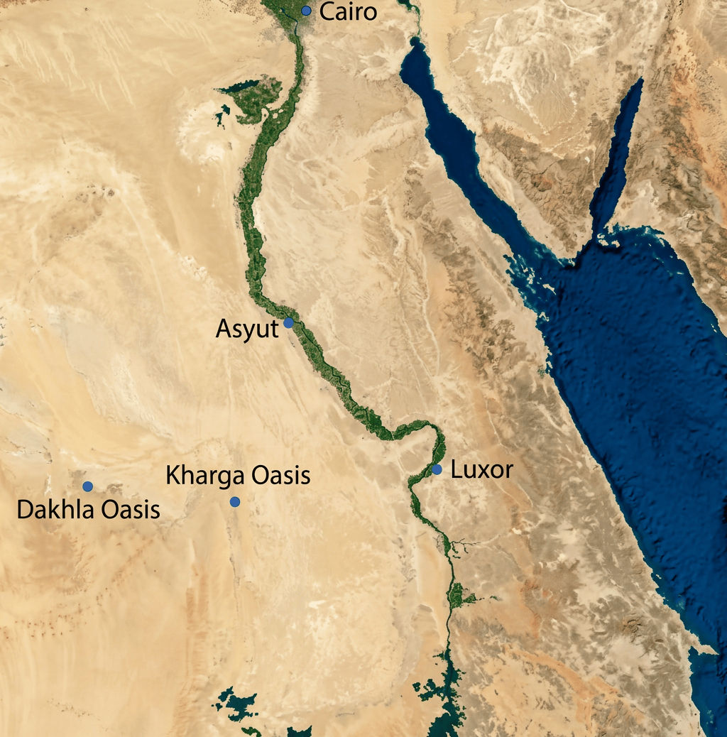
KS043 lies in the southern basin of Kharga Oasis, in the Libyan Desert/Western Desert of Egypt
The oasis itself is roughly 200 km west of the Nile Valley. KS043 lies about 12 km southwest of Dush, on a sandy plain near the ancient spring complex called ʿAyn el-Nakhla / ʿAyn el-Hadduda [1].
The geography is striking
To reach the Nile from Kharga meant crossing roughly 200 km of desert. The oasis therefore wasn’t a suburb of the Nile. It was a genuine desert environment with its own water system. The nearest major sea is the Red Sea, east of the oasis, while the Mediterranean is much farther north. KS043 was therefore very much an interior desert settlement, not a coastal site.

What did Kharga look like?
It is tempting to picture the modern Western Desert and simply put Neolithic people into it. That would be misleading. Kharga’s landscape has changed dramatically. During earlier wet periods, the depression contained lakes, wetlands, springs and streams. Geoarchaeological work has identified fossil spring deposits, freshwater molluscs and ancient lake environments. During some Pleistocene wet phases, Kharga supported substantial surface water [3][4]. By the Neolithic, however, the landscape was much drier. At KS043 the archaeological evidence indicates contracted desert vegetation, seasonal grasses, wild legumes, acacia, tamarisk, salt-tolerant plants, gazelle habitat and localized vegetation around water. So this was not a forest. Nor was it a completely lifeless sand sea. It was more like a desert steppe containing isolated green pockets around groundwater.
They had ancient lakes in the Kharga region but KS043 itself was associated with springs rather than a large lake
UNESCO’s description of the broader Kharga landscape notes that around 10,000–12,000 years ago, parts of the depression contained a large lake; as the lake shrank, later prehistoric occupation moved into lower parts of the oasis [5].
Geoarchaeological work has also documented spring-fed streams, ponds and freshwater bodies during earlier humid phases [3]
By the time KS043 was occupied, however, the crucial water source was groundwater emerging through artesian springs.
The heart of the site was artesian groundwater
Deep underground, water was stored in the enormous Nubian Sandstone Aquifer System. This aquifer covers more than two million square kilometres beneath parts of northeastern Africa. During wetter climatic periods, groundwater was recharged. Layers of relatively permeable sandstone alternate with less-permeable shale, creating conditions in which groundwater could become pressurized [1][3]. At suitable geological locations, the pressure pushed groundwater toward the surface. Imagine drilling down through the desert and finding water that wants to rise by itself. That is why an oasis could exist in a place that receives almost no modern rainfall.
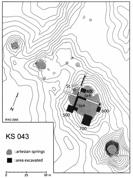
They actually dug into the spring
This is the extraordinary archaeological discovery at KS043. Researchers identified a large fossilized artesian spring head. During the Neolithic, people dug directly down into the old spring shaft. The artificial well reached approximately 2.6 metres below the surface [1]. A wonderful example of prehistoric engineering.
When did the springs disappear? An important distinction between the KS043 spring, and all Kharga springs
The evidence shows a progressive decrease and eventual disappearance of spring activity at KS043 during the occupation sequence. Researchers interpret the well as an attempt to reach the declining aquifer after surface flow weakened [1]. The occupation itself continued until roughly 4000 BC, with Bayesian modelling placing the broader KS043 occupation between about 5000 and 3950 cal BC [2]. Different springs had different histories though. Kharga continued to support later populations with groundwater, wells and eventually engineered water systems.

Where geology and archaeology become almost inseparable
Researchers didn’t simply find a hole and declare it a well. They found: fossilized spring deposits, argillite deposits produced by spring activity, different sedimentary layers, spring mounds, ancient, water conduits, mineralized deposits and stratified archaeological layers. At KS043, the archaeological deposits were interleaved with sediments deposited by the springs themselves.
The excavation therefore contained a kind of environmental diary
Spring activity created one layer. People occupied the surface. A hearth formed. More sediment accumulated. The spring shifted. People returned. Another hearth was made. Eventually the spring weakened. People dug the well. The whole sequence became buried.
Geoarchaeologists reconstructed this history through: stratigraphic excavation, hand augering, sediment analysis, geomorphology, fossil spring deposits and radiocarbon dating [1][2].
Partly and one reason why it survived was because it was buried in sand
The KS043 site sits on a sandy plain, with substantial reddish sand deposits, locally more than 3 metres thick. Fossil roots show that portions of this sand surface were once vegetated [1].
The charcoal record is dominated by Acacia, Tamarix and chenopod shrubs
There were also Ziziphus fruits and other plants [1]. It indicates an enviornment closer to desert scrub, river/oasis vegetation and seasonal grassland. The presence of tamarisk and salt-tolerant chenopods also suggests localized saline soils, probably where spring water collected and evaporated [1].
Grasslands? Yes but not continuous
Wild grasses and legumes occur abundantly in the archaeobotanical samples. They may have been natural grazing vegetation, food, fodder and plant material incorporated into animal dung. This last possibility matters. About 70% of the archaeobotanical samples contained caprine dung, and therefore some of the grass and legume seeds may have arrived in the hearths as partially digested animal fodder rather than as food collected deliberately by humans [1]. Archaeology requires caution. A seed in a hearth does not automatically mean someone ate it.
An interesting find. There is evidence for wheat
But it does not look like substantial local agriculture. Eight grains of emmer wheat were recovered. Researchers noted: very small quantity, no chaff and excellent preservation of other plant remains. They therefore argue that the emmer was probably transported to KS043 as cleaned grain, most likely from the Nile Valley [1].
What plants did they have?
Directly identified: Acacia, Tamarisk, and Ziziphus spina-christi — Christ’s thorn/sidr, producing edible nabaq fruit. Citrullus colocynthis or colocynth/wild gourd. And, Chenopodiaceae or salt-tolerant plants including Suaeda-type plants.
Wild grasses;
Wild legumes: Cyperaceae; and
Various other small-seeded plants.
Emmer wheat is the only securely identified domesticated crop in the KS043 assemblage [1].
They probably had a combination of Domestic animals
Including: sheep, goats, cattle, dogs, Wild animals, Dorcas gazelle, Barbary sheep, hare, ostrich, small birds, rodents and possibly other desert game [1]. The archaeological faunal assemblage contains more than 30,000 bone fragments, although poor preservation meant only about 19% could be identified [1].
Sheep/goat remains are particularly numerous, followed by cattle
A later review notes approximately 1,800 sheep/goat bones compared with fewer than 600 cattle bones among the identified KS43 material; pigs are absent [6]. The animals appear to have been raised primarily for meat, although very young caprines may also suggest milk exploitation [1]. Researchers have proposed that the community was mobile and pastoral, possibly using KS043 particularly during the winter season [6].
Fish—and a surprising clue to the Nile
There are a few catfish bones. But this is extremely unusual. The fish were apparently large enough to require relatively deep water. The researchers concluded that KS043 probably did not contain a sufficiently deep local body of water to support such fish. Therefore they probably came from the Nile Valley [1]. Two Nile freshwater bivalves were also found: Spathosis rubens and Corbicula consobrina. These are another indication of contact with the Nile [1]. So even though KS043 was 200 km from the river, the Nile was still part of its economic world.
One extraordinary animal was also found
Cheetah. A cheetah ulna was found and was apparently made into a bone point [1]. That’s a remarkable object.
Architecture?
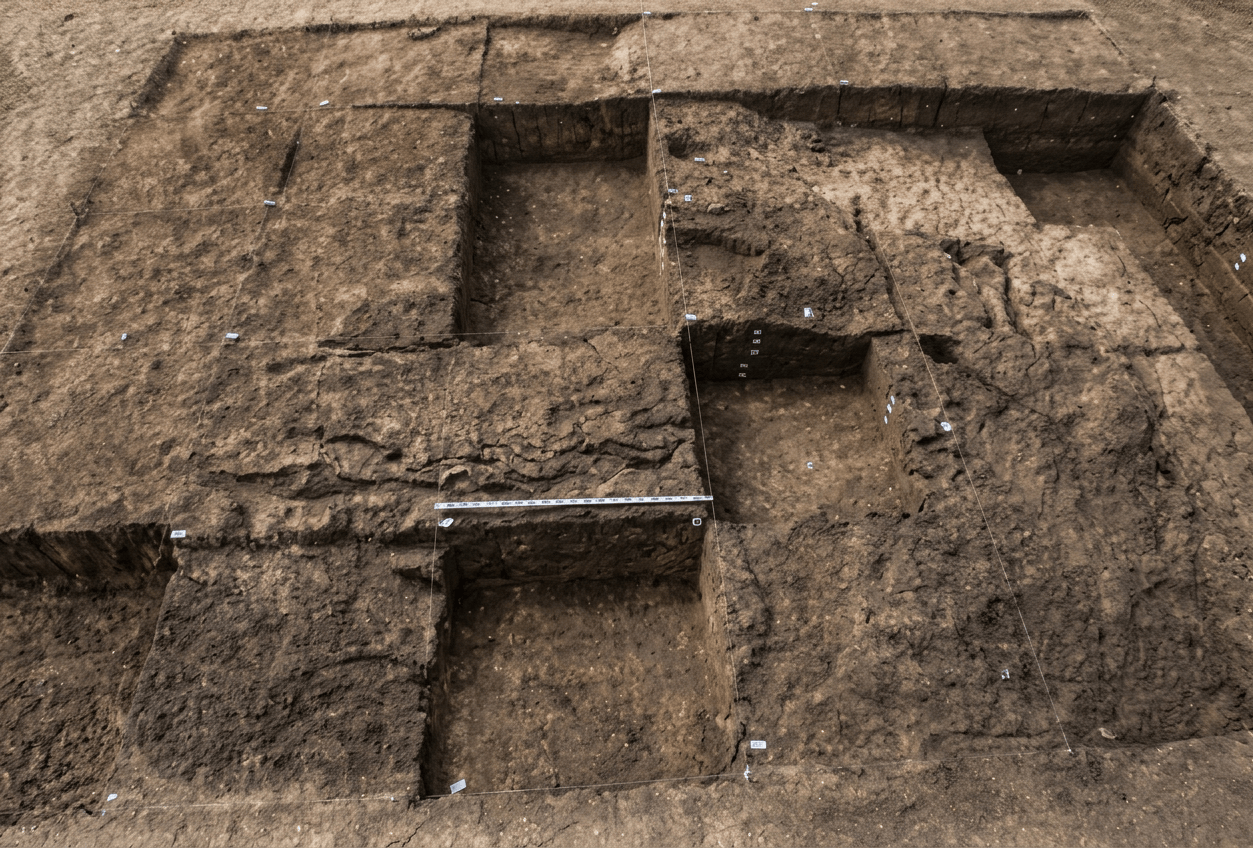
Excavators found seasonal housing and numerous domestic activity areas. The IFAO description explicitly identifies: “hearths and depressions coated with clay. Seasonal housing under excavation.” [7] The excavated settlement contained numerous closely spaced domestic features: hearths, small oval pits, clay-lined depressions, working surfaces, querns, grinding stones, pottery and animal remains. The pits were generally 30–60 cm long, and 10–15 cm deep. With the largest approximately 1 metre across [1]. Some appear to have been used for water storage.
Were the houses subterranean?
Not in the sense of a subterranean house or underground village. But the settlement had depressions and shallow sunken features. The important genuinely deep structure was the water well, not a dwelling.
A better image would show: light seasonal shelters, hearths, shallow clay-lined pits, livestock, water source
No large ceremonial building comparable to Nabta Playa or Hierakonpolis HK29A has been identified at KS043
However, there are hints of ritualized behavior. One complete bowl was deliberately placed upside down over a clay spoon and a Nile shell, apparently creating a small deposit [1]. It may represent: a deliberate offering, a foundation deposit, abandonment behavior and a special household deposit.
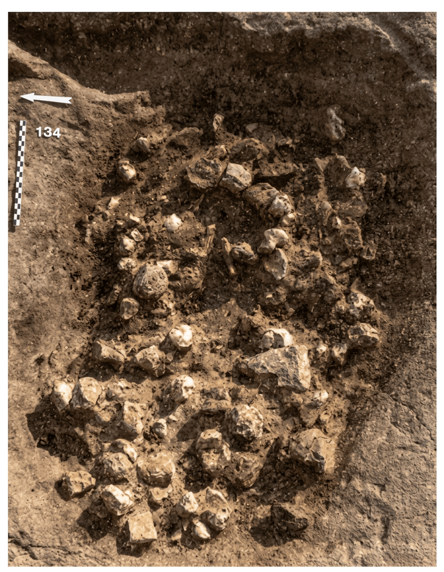
Hearths are among the most abundant archaeological features
Charcoal from the hearths was crucial for radiocarbon dating. Hearths contained: charcoal, ash, animal bone, caprine dung, carbonized seeds and ostrich eggshell. The people were therefore literally burning a mixture of wood and animal dung.
The pottery is one of the site’s best chronological clues
Its believed there were 1,662 sherds. Representing about 114 pottery vessels/items [1]. Most were plain vessels. There were also: Black-Topped Ware, Tulip-Beakers, Ripple Ware, red-slipped/burnished vessels and decorated globular vessels.
The pottery connects KS043 to Tasian cultural traditions
This is significant because the site helped establish that Tasian traditions were not simply a Nile Valley phenomenon—they also existed within the desert landscape.
Toolmaking
The chipped-stone industry is unusually interesting. The toolkit includes: microliths, backed segments, transverse arrowheads, triangular arrowheads, borers, becs, denticulates, notches, scrapers and bifacial knives. The raw material included chalcedony. Even more interestingly, people frequently reused Middle Stone Age flakes lying around the site [1]. So imagine a Neolithic pastoralist picking up a stone flake that had been made by another human population thousands of years earlier and turning it into a new tool. A wonderful example of landscape recycling.
There were also handstone technology: querns and grinding stones. Many were made from sandstone or quartzite. They were particularly common around the well [1].
The diorite macehead
One of the most unusual finds is a diorite macehead. It is rare among the site’s material and may represent an object with symbolic or prestige significance [1]. The authors note that its material provides a possible connection toward the Eastern Desert [1]. The site wasn’t isolated. People and objects were moving across the desert.
Precious stones and metals
KS043 isn’t a gold-mining settlement. Nor is there evidence for a major metalworking industry. But the site participated in long-distance networks. There are: ornaments, shell, bone, mineral pigments, diorite and copper-related material.
The bowl deposit included a Nile shell showing traces of copper mineralization, possibly associated with a coloring substance [1].
The broader Kharga archaeological sequence includes exotic materials such as shell, ostrich eggshell ornaments, agate and other stones [8].
Mineral pigments are present in the broader Kharga Neolithic record, and the KS043 material includes a Nile shell apparently associated with copper mineralization that may have been used as a coloring material
But KS043 is not particularly famous for ochre burials in the way Gebel Ramlah is. This is another useful distinction between sites.
Ostrich eggshell is common enough to be important It occurs in the settlement and hearths
Ostrich eggs were also an important technological resource across the Sahara: containers, beads, ornaments and water storage. At KS043 they were especially important because fragments from hearth contexts were used in attempts to radiocarbon-date the site. There was, however, a dating problem. Ostrich eggshell dates from the same contexts were hundreds to more than a thousand years younger than associated charcoal [2].
KS043 sits between the Eastern Sahara and the Nile Valley
They lived here for water and pasture. The site therefore functioned as part of a corridor through which people, livestock, foods and objects could move [1]. The researchers describe mobile pastoral groups between Kharga and the Nile as creating a conduit for contact and long-distance exchange [1].
10 thousand years ago, the Kharga landscape was considerably wetter
Earlier in the Holocene, seasonal rainfall and groundwater conditions supported lakes, ponds, springs, wetlands, vegetation and animals. Geoarchaeological evidence shows that the distribution of prehistoric sites changed as water bodies shrank [3][5].
Around the Pleistocene-Holocene transition, roughly 10,000 years ago, many springs and wadis began to dry while some pans retained seasonal water [3].
Around 8,000–9,000 years ago, the broader Sahara was still within the African Humid Period
Kharga experienced significantly wetter phases than today, although rainfall was highly variable. The enormous Nubian aquifer had been recharged during earlier humid phases and could continue releasing groundwater long after surface rainfall declined [1][3]. It created a kind of environmental time lag. The rain stopped becoming reliable before the groundwater disappeared. One reason oases could remain habitable while the surrounding desert became progressively drier.
6000 years ago, the African Humid Period was weakening
In parts of the Western Desert, rainfall was becoming increasingly seasonal and unreliable. Kharga nevertheless retained groundwater and localized wet environments. This is the background to the development of increasingly mobile pastoral economies.
The crucial moment. 5,000 years ago KS043 appears
5000 BC, the surrounding Sahara was becoming considerably less hospitable. Pastoralists could no longer depend upon the old widespread grassland/wetland network. Instead water became concentrated. The remaining reliable locations became increasingly valuable. KS043 ended up being one of those places. The people were not necessarily “settling the desert.” They were following the remaining ecological infrastructure.
Around 4500–4000 BC the spring was weakening
People were still living there. They increasingly needed to extract water from deeper underground. Eventually spring went to weaker spring to spring head to dug well to last groundwater. The archaeological layers actually record this process [1].
How do we know? Not just one clue
Researchers combine: 1. Fossil springs. Mineral deposits produced by ancient flowing groundwater.
2. Lake sediments. Layers preserve environmental change.
3. Freshwater molluscs. Their presence demonstrates ancient aquatic environments.
4. Pollen and plant remains. Changes in vegetation reveal moisture availability.
5. Charcoal. Reconstructs woody vegetation and fuel use.
6. Animal remains. Gazelle, Barbary sheep and other species indicate particular habitats.
7. Stable isotopes. Carbon and oxygen isotopes can reconstruct hydrology and environmental conditions.
8. Radiocarbon. Dates charcoal, seeds and other organic remains.
9. Sedimentology. Spring-produced argillite layers can literally record changing water discharge.
10. Geomorphology. Ancient lake shorelines, wadis and spring systems reveal the former landscape.
At Kharga, researchers have even used uranium-series dating of fossil spring tufas to establish the timing of ancient wet phases [3].
People eventually changed locations, adapted their water technology and reorganized settlement [8].

The site was part of a much bigger network
Nearby prehistoric Kharga sites include: KS052, KS043, ML1, Ayn Manawir and numerous smaller spring sites.
There are also Palaeolithic localities around the oasis.
ML1 is particularly interesting because it represents a 7th-millennium hunter-gatherer campsite near an artesian spring [9]
A local Kharga sequence: hunter-gatherers, pastoralists, increasingly arid oasis, agricultural communities and later irrigated oasis society.
What is particularly “Neolithic”
A combination of pastoralism, pottery, ground stone, chipped stone, recurrent settlement, water management, food storage/processing and environmental adaptation. It demonstrates another very important fact about the Neolithic: A Neolithic society did not have to be a permanent farming village. KS043 shows a mobile pastoral Neolithic in which people could have livestock, pottery and grinding stones while still moving through an arid landscape.
KS043 is a Neolithic pastoral settlement where archaeologists can actually see people responding to climate change in the architecture of water: as an artesian spring weakened, they dug down into it to reach the last groundwater. That is extraordinary. It means climate adaptation isn’t an abstract modern concept. Five thousand years ago, people were already responding to environmental change by: changing where they lived, changing how they obtained water, changing how they moved livestock, importing food, exploiting new plants and intensifying groundwater use.
KS043 is constructed different from other sites
Picture a winter/seasonal settlement around 4500 BC. A cluster of light seasonal shelters stands around a spring. Nearby: sheep and goats, cattle, dogs, hearths, clay-lined pits, grinding stones, pottery, ostrich eggshell, bundles of gathered vegetation and animal dung being burned as fuel.
Beyond the settlement are acacia, tamarisk trees; grasses and salt-tolerant plants. Further away bare desert, dunes and rocky escarpments. While at the center is a spring. Then, as the spring weakens, someone digs deeper. That hole becomes the most important “building” in the settlement.
Major excavation work was conducted between 2002 and 2008 by a multidisciplinary team associated with the Institut français d’archéologie orientale (IFAO).
The broader Douch/Kharga prehistoric program has now been formally listed by IFAO as completed, but the research and publication record continues, and the wider oasis is still being investigated with modern methods [9].
Modern Kharga research is also using ground-penetrating radar and other non-invasive geophysical techniques at archaeological sites, demonstrating how much buried archaeology can be studied without simply excavating everything [10].
What could we do to help?
- Make research visible. The site is much less familiar to the public than Nabta Playa. A clear, well-sourced article explaining the site helps prevent the Western Desert from being treated as an archaeological blank.
- Cite the original research. The most useful starting point is Briois et al.’s original 2012 excavation publication [1]. Briois et al., “Neolithic Occupation of an Artesian Spring: KS043 in the Kharga Oasis”
- Support the IFAO. The Institut français d’archéologie orientale maintains the long-running Douch/Kharga research tradition and provides ways to support its archaeological and preservation work [11].
- Encourage non-invasive archaeology. KS043 is an excellent example of why: GPR, sediment cores, geochemistry, archaeobotany, zooarchaeology and radiocarbon. Can reveal an enormous amount without excavating every square metre.
- Protect the landscape. Wind erosion, dunes, modern development, agriculture and uncontrolled collecting can destroy precisely the ephemeral evidence that makes sites like KS043 important.
The bigger Kharga story. KS043 fits beautifully into the larger Neolithic Architecture sequence
12,000+ years ago. Ancient Kharga lakes and wetlands. Hunter-gatherers;
10,000 years ago. Holocene environmental transition. Springs, seasonal ponds and vegetation;
8,000 years ago. African Humid Period. Much greater regional water availability;
6,000 years ago. Pastoralism expands. Livestock + seasonal movement;
5,000 BC. Increasing aridity. Water becomes concentrated in oases;
4600 to 4350 BC. KS043. Pastoralists, pottery, hearths, livestock, imported grain;
4500 to 4000 BC. Spring weakens. People dig into the artesian spring;
4000 BC. Settlement ends. Increasing desertification and changing water availability; and,
Later. Oasis agriculture. Increasingly sophisticated wells and irrigation systems.
And, that gives KS043 a very powerful architectural message: When climate changes, architecture may begin with a house, but survival depends on the whole water and landscape system.
References: [1] Briois, F., Midant-Reynes, B., Marchand, S., Tristant, Y., Wuttmann, M., De Dapper, M., Lesur, J. & Newton, C. (2012). Neolithic occupation of an artesian spring: KS043 in the Kharga Oasis, Egypt. Journal of Field Archaeology 37(3): 178–191.
[2] Wuttmann, M., Briois, F., Midant-Reynes, B. & Dachy, T. (2012/2016). Dating the End of the Neolithic in an Eastern Sahara Oasis: Modeling Absolute Chronology. Radiocarbon 54(3–4): 305–318.
[3] Smith, J. R. et al. (2004). A reconstruction of Quaternary pluvial environments and human occupations using stratigraphy and geochronology of fossil-spring tufas, Kharga Oasis, Egypt. Geoarchaeology 19: 407–439.
[4] Smith et al. / Blackwell et al. — studies of fossil springs, groundwater, molluscs and prehistoric occupation in Kharga and the Western Desert.
[5] UNESCO World Heritage Centre, Kharga Oasis and the Small Southern Oases — environmental and archaeological history of the oasis.
[6] Linseele et al. (2014). New Archaeozoological Data from the Fayum “Neolithic” with a Critical Assessment of the Evidence for Early Stock Keeping in Egypt. PLOS ONE 9(10).
[7] IFAO, Douch — La préhistoire holocène du bassin de Douch, including the KS43 excavation documentation.
[8] Dachy, T., Briois, F., Marchand, S., Minotti, M., Lesur, J. & Wuttmann, M. (2018). Living in an Egyptian Oasis: Reconstruction of the Holocene Archaeological Sequence in Kharga. African Archaeological Review 35: 531–566.
[9] IFAO, Douch / Holocene prehistory of the Douch basin.
[10] Ebraheem, M. O., Ibrahim, H. A. & Zalat, M. M. (2025). Revealing the past of Ginah archaeological site by enhancing GPR images to understand ancient periods at Kharga Oasis, Egypt. Scientific Reports 15.
[11] Institut français d’archéologie orientale, support and research programs.
Leave a Reply