<home # start here # guides # builds # services # shop # about # categories>
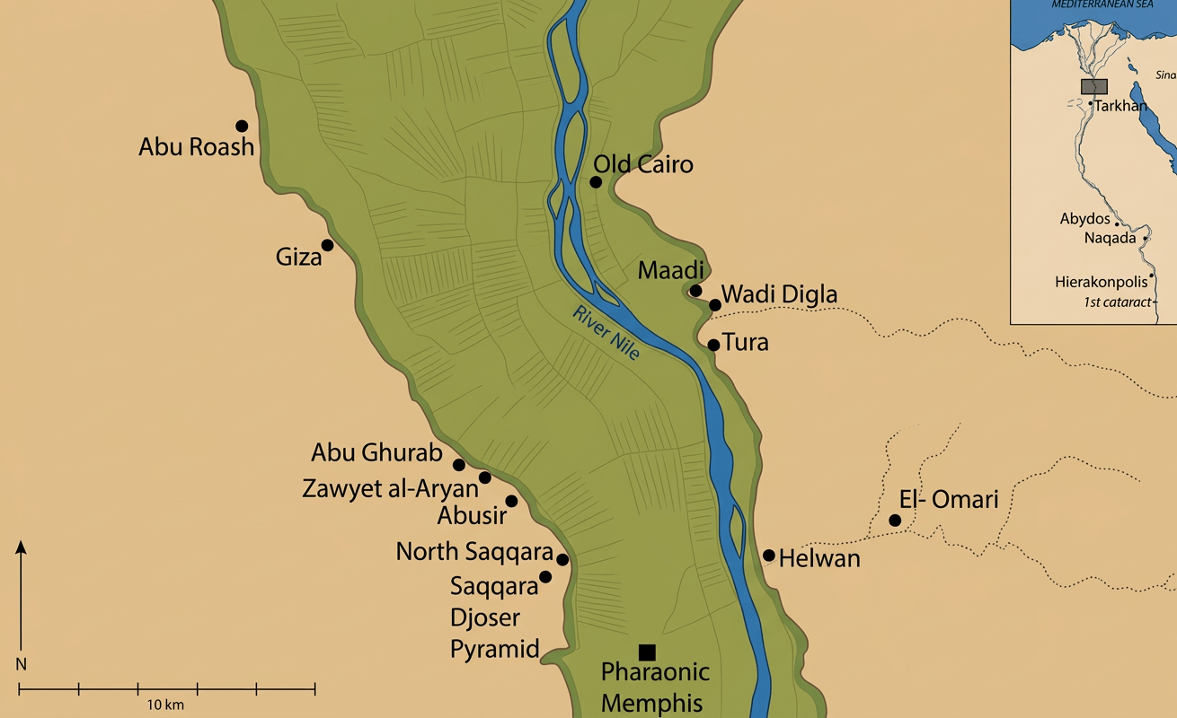
El Omari is one of the most interesting early Neolithic settlements in northern Egypt because it sat directly at the meeting point of three environments: Nile floodplain, desert edge, and Wadi Hof
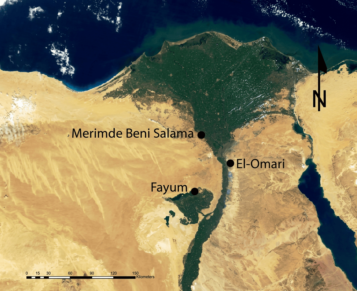
It was not a huge mudbrick city. It was a settlement of lightweight huts, pits, storage installations, hearths, craft activity and burials, occupied roughly 4600–4400 BC according to the commonly used calibrated chronology. It was broadly contemporary with the later phases of Merimde Beni Salama and the Fayum Neolithic, and it should not be classified as Badarian. [1][2]
El Omari shows that a Neolithic community could be agricultural and pastoral, but still build mostly with organic, portable or semi-subterranean architecture rather than permanent mudbrick houses.
El Omari lies near modern Helwan, south of Cairo, at the mouth of Wadi Hof, on the eastern side of the Nile Valley
The site is usually described as about 5 km north of Helwan, while the principal settlement lay roughly 4–4.5 miles (6–7 km) east of the Nile in the older archaeological descriptions. [1][3] This is important because it was not a remote desert oasis. It was positioned on a Pleistocene gravel terrace at the desert margin, where people could exploit Nile floodplain, springs, wadi and limestone desert. All within a relatively small area. Geological work specifically emphasizes that the location allowed access to the Nile floodplain, Wadi Hof and perennial springs. [4]
The settlement was approximately 6–7 km from the modern Nile channel, although the ancient river landscape was not identical to today’s river
This was an excellent position. People did not have to live directly on the floodplain, where annual flooding could be dangerous. Instead, they could live slightly higher on the desert terrace while moving down to the Nile for: fishing; water; floodplain crops; reeds; birds; aquatic animals; and transportation. At the same time, the wadi gave them access to the desert. Exactly why geoarchaeologists describe El Omari as a settlement “utilizing both desert and river environments.” [4]
How did they get water?
They were close to the Nile, but geological research also identified springs in the vicinity. Neolithic artifacts were found particularly near these perennial springs. [4] Modern geological research shows that the Helwan area has a complicated groundwater system involving: fractured Eocene limestone; deeper aquifers; faults; wadis; surface seepage; rainfall; and groundwater emerging at springs. Wadi Hof is one of three major drainage basins feeding the Helwan area. [6] An unusally attractive prehistoric water strategy. Sources included Bile water below, spring water beside the settlement and occasional wadi runoff from the desert.
The Red Sea was 90 to 110km or less than a few days away
Wadi systems leading eastward through the Eastern Desert provided natural corridors toward the Red Sea. And, there is archaeological evidence that El Omari’s inhabitants were connected to distant environments. Red Sea shells occur among the material culture, while other minerals and stone resources came from desert regions. [7]
Was El Omari buried in sand or archaeological deposits? Is it threatened?
The site was on the eastern desert margin, but its greatest modern threats have been urban development, roads, military use, collecting and other disturbance. The original excavation was undertaken partly because the site was in danger of destruction by private collectors, sebakh digging and military activity. [8] One part of the site is now particularly difficult or impossible to investigate archaeologically because of modern development and restricted areas. This makes El Omari an important example of another problem: Sometimes an archaeological site disappears not because the desert buries it, but because the modern city builds over it.
Imagine El Omari about 6,500 years ago
To the west, the Nile and its green floodplain. Immediately around the settlement: gravel terrace, grass, shrubs, reeds and scattered trees.
To the east: Wadi Hof and limestone hills. Beyond: the Eastern Desert. It was probably a mosaic landscape, not forest.
Archaeobotanical evidence identifies wood from trees including acacia, tamarisk and other woody plants used for fuel. Sycamore fig and date palm remains were also recovered [9]
A better reconstruction is riverine woodland and scattered trees beside a grassy/wetland Nile corridor, grading rapidly into open desert vegetation.
There were probably more grasslands
The evidence for agriculture and wild plant collection, combined with the availability of livestock grazing, suggests a landscape capable of supporting grass and herbaceous vegetation, particularly around the floodplain and wetter parts of the wadi system. The presence of wild halfa grass used for basketry is especially interesting. [9]
Was there a wetter Sahara 10,000 years ago? Yes, but the wider Sahara needs to be distinguished from El Omari
The African Humid Period produced much wetter conditions across large parts of North Africa. Around 9,200–4,200 years ago, evidence from the lower Nile indicates a major humid interval, with shorter dry episodes within it. (climate [10])
Date Broad environmental picture
10,000 years ago Much greener Sahara; lakes, grasslands and seasonal rivers in many areas
8,000 years ago Strong African Humid Period
6,000 years ago Increasingly unstable/drying conditions
5,000–4,000 years ago Strong regional aridification
4,000 years ago Major development of hyper-arid Sahara conditions
The important point is that the transition was not a single worldwide switch. Drying occurred at different times in different places (climate [10][11])
El Omari’s occupation occurs around 4600–4400 BC. During the broad transition toward a drier North Africa
But the dramatic hyper-aridification seen in later Holocene Egypt occurred substantially later.
The site was identified in 1924 by the Egyptian mineralogist Amin El-Omari, working with the French priest and prehistorian Paul Bovier-Lapierre
Bovier-Lapierre excavated for approximately two weeks in 1925. Fernand Debono returned to the site beginning in 1943 and conducted further campaigns in 1943–44, 1948 and 1951. The complete excavation report was eventually published by Fernand Debono and Bodil Mortensen in 1990. [1][8][13]
What were the houses like?
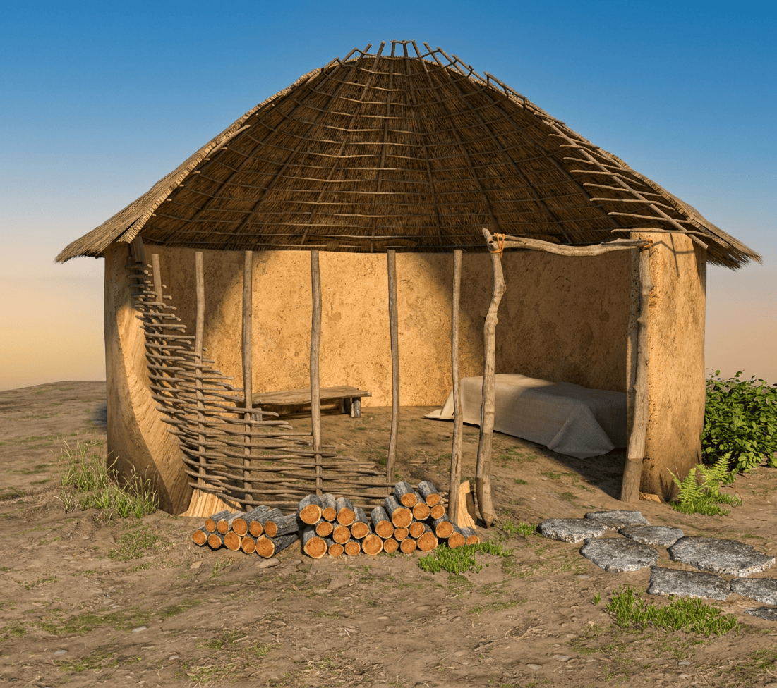
This is where El Omari becomes particularly valuable. The actual houses are mostly gone. What survived were: pits; postholes; hearths; storage installations; rubbish deposits; and fragments of organic materials. Archaeologists reconstruct round or oval huts, sometimes partly sunk into the ground, with lightweight superstructures. [14]
Some interpretations reconstruct more than 100 small circular or oval residential structures across the occupation area, although they were not all occupied simultaneously. The settlement shifted horizontally through time as old houses were abandoned and new ones constructed. [15]
One of the strongest architectural characteristics of El Omari are subterranean or sunken buildings
Some houses appear to have been partly sunk below ground level, producing an oval or circular depression. The pits range considerably in size, and some may instead represent storage or other activities, so not every pit should be called a house. The safest reconstruction is: semi-subterranean oval huts and lightweight superstructures. That makes El Omari an excellent architectural comparison with: Merimde; Fayum; some later Delta settlements; and certain desert pastoral settlements.
Timber? Yes. Postholes demonstrate that wooden posts formed part of the structures
Some pits contained traces of smaller poles supported by stones, while larger post impressions may represent roof supports. Smaller recesses may have belonged to internal wall structures. [16] So the structural sequence probably looked something like: wooden posts, woven/reed framework, mud coating and roof.
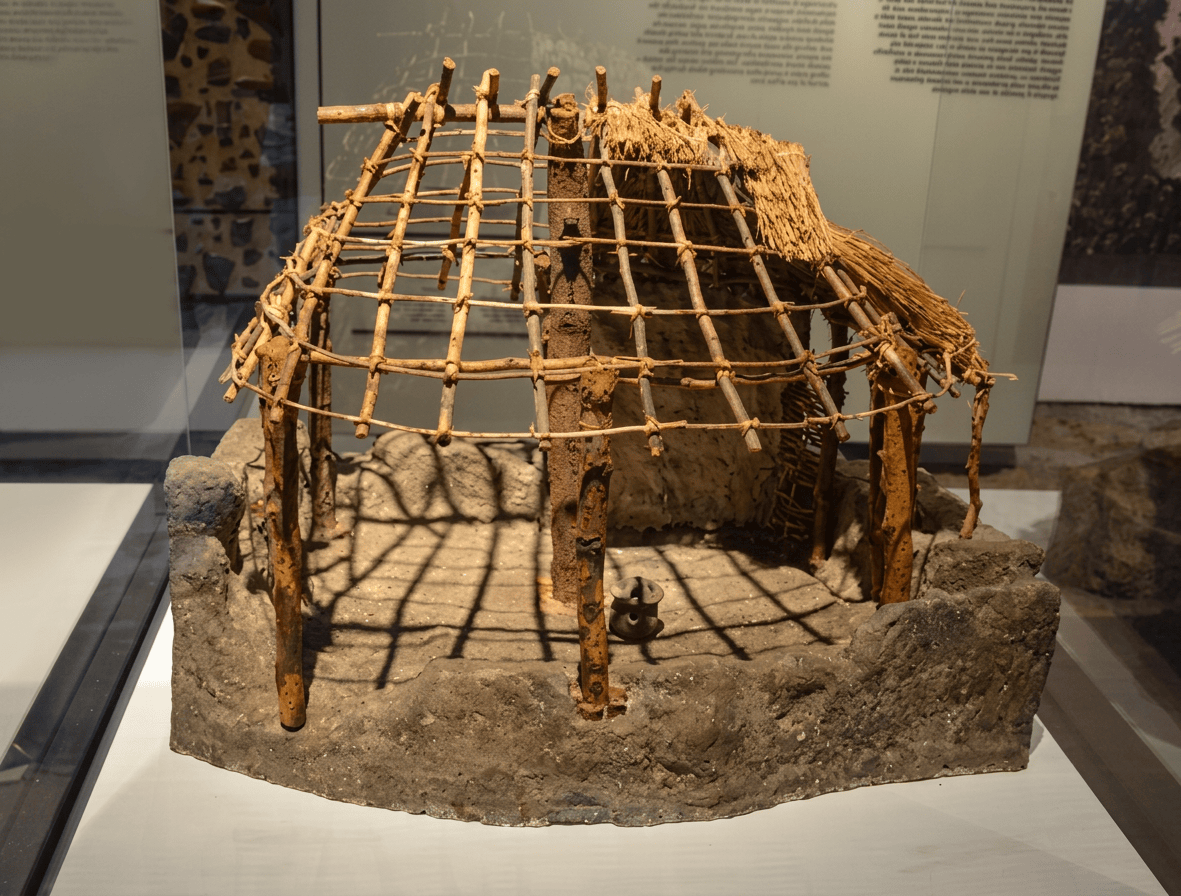
Wattle and Daub was very likely
The standard interpretation is that the huts used wattle-and-daub or related reed-and-mud construction. The archaeological evidence is indirect because the organic framework has mostly disappeared, leaving postholes and impressions. But this reconstruction is supported by: wooden posts; light structural elements; organic matting; reeds/grasses; clay; and semi-subterranean pits. [1][16]
Mudbrick? An important distinction
Mud was definitely used. But substantial mudbrick architecture is not securely demonstrated for the classic El Omari settlement. The architecture seems to have been primarily: pit, timber, reed/wattle and mud. Rather than a large rectangular mudbrick house. Like some places in the Levant and elsewhere. This makes El Omari substantially different from later Egyptian towns.
No substantial stone houses are securely known
Stone was nevertheless extremely important for: axes; blades; sickles; grinding stones; ornaments; tools; and occasional lining around pits and graves. Stone was primarily a technology and resource, not the main structural architecture.
Hearths were found both inside and outside residential areas, together with domestic refuse and artifacts
This suggests that cooking and food processing occurred in and around the huts rather than in a specialized communal kitchen. [16]
There is no convincing evidence for a large specialized bakery or monumental oven complex. Cooking seems to have been based primarily around hearths and domestic fire installations.
Furniture?
There is no securely reconstructed collection of: wooden chairs; beds; tables; and benches. But this does not mean the houses were empty. They used mats; baskets; woven containers; wooden implements; pottery; grinding stones; storage pits; hides; and textile/fibre objects. The mat may have functioned as: floor, bedding, container lining and burial covering. Another example of multifunctional Neolithic technology.
Storage was extremely important
El Omari had: storage pits; mud-lined storage installations; basket-lined containers; and large pottery vessels. The pits were sometimes later reused for other purposes, including burials. [8][16] This means a single architectural feature could have a life cycle: storage, abandonment, rubbish and burial. That’s a very useful concept for your architectural database.
El Omari was not simply a fishing camp. They had agriculture
Plant remains demonstrate cereal agriculture, including: emmer wheat; barley; club wheat; and einkorn wheat, probably as a weed rather than a principal crop. [9][17] Modern archaeological syntheses specifically identify storage pits containing emmer wheat and barley. [17]
Lentils and peas? Evidence is much weaker
Vetches were identified, but this should not automatically be translated into “peas” or “lentils.”
Yes flax
Flax was present and was used for textile production. A flax capsule was identified in the botanical assemblage. [9] This means El Omari was not merely growing food.
Grasses and basketry evidence is excellent
Wild halfa grass was used for basketry, while plant fibres were also used in mats and ropes. [9] This is extremely significant architecturally. A basket may preserve only a few fibres. A reed wall may leave only postholes. A rope may disappear completely. So El Omari’s surviving stone and pottery assemblage probably greatly underrepresents the importance of fibre technology.
Botanical remains include: sycamore fig, date palm, vetch, flax, cereals and various woods used for fuel [9]
El Omari gets fascinating with animals
Animal Evidence
Pig 183
Cattle 152
Sheep/goat 88
Hippopotamus 56
Goat 7
Sheep 7
Dog 6
Donkey 3
Gazelle 1
Antelope 1
These are reported bone counts, and they should not be interpreted as exact population sizes or percentages of the diet. Preservation, excavation and identification biases strongly affect such numbers. [18]
However an overall picture is very clear: El Omari was an agro-pastoral community with an unusually strong aquatic/fishing component.
Pigs are less useful as mobile desert livestock than sheep/goats or cattle
The presence fits a community with access to: wetland vegetation; agricultural waste; household food refuse; and relatively reliable water. [18]
Cattle were also extremely important
That combination: pig, cattle and sheep/goat. Is a strong indication that El Omari was not purely pastoral. It was a mixed settlement economy.
Sheep and goats lower numbers should not be treated as a direct measure of herd size
They are valuable for meat; milk; hides; fibre; and mobile herding.
56 hippopotamus specimens were identified in the published faunal assemblage [18]
Crocodile remains are present.
This is another reminder that the ancient Nile was an entirely different ecological environment from a modern urbanized Cairo waterway
Fish assemblage includes: Nile perch (Lates niloticus); tilapia; catfish; Synodontis; Mormyrus; Distichodus; Bagrus; Polypterus; and other Nile fishes [18]
Fishing technology included bone hooks and possible net weights, while some stone tools may also have had fishing functions.
Wetland environment also supported numerous birds. Including: Egyptian goose; white-fronted goose; teal; quail; cattle egret; purple heron; spur-winged plover [18]
This makes the landscape much easier to visualize. It was not desert and Nile. A better picture is desert, wadi, springs, river, marsh, fish, birds, grazing animals and cultivated floodplain.
How mixed was the economy?
Very mixed. I’d visualize the annual economy roughly as: Nile: fishing, birds and aquatic resources;
Floodplain: cereals and grazing;
Settlement: pigs, cattle, sheep/goats and storage;
Wadi: fuel, wild plants, springs and seasonal grazing; and
Desert: stone, minerals, hunting and routes toward Eastern Desert resources.
This ecological diversity is probably one of the main reasons the location was attractive.
Tools
El Omari’s lithic technology included: flakes; bifacial axes; sickle blades; points; knives; scrapers; perforators; arrowheads; grinding stones; and pestles. [1][19]
Some tools were highly specialized. Particularly interesting: bifacial axes. These required substantial knapping skill.
Sickle blades. These indicate harvesting/processing plants.
Fish hooks. These demonstrate specialized aquatic technology.
Grinding stones. These demonstrate cereal and plant processing.
Bone and shell technology
Bone was used for: needles; perforators; and hooks.
Shell was used for: ornaments; beads; and fishing equipment. Red Sea and Mediterranean shells demonstrate long-distance connections. [18][20]
Precious stones and minerals
El Omari was not a gold-mining settlement. But it participated in a surprisingly broad raw-material network. Objects/materials include: shell; stone beads; limestone; hematite; crystalline stones; flint; and galena. Small pieces of galena, wrapped in leather, may have come from the Sinai or Eastern Desert. [20] The large gray flint used for some knives may have originated outside the immediate settlement area, possibly toward the western Negev. [20] The site was not isolated.
El Omari appears to have had much less copper and ivory than the Badarian assemblage [21]
It suggests different trade networks and perhaps different social priorities.
El Omari pottery was largely made from local clay rather than Nile sediments
Petrographic, mineralogical and chemical analyses demonstrated that local clay sources were being used, and firing temperatures could be investigated scientifically. [22] This is a wonderful example of modern science extracting information invisible to the original excavators.
Did they decorate their pottery?
El Omari pottery is generally less spectacular than later Naqada pottery. Its importance is technological and chronological rather than monumental. There are connections to the pottery traditions of: Merimde; Fayum; the wider northern Egyptian Neolithic; and possibly the Levant. The relationship with Palestinian/Levantine ceramic traditions has been debated. [23]
Ochre occurs at El Omari
It appears to have had cosmetic and/or ritual possibilities, although the exact function of individual occurrences cannot always be established. This is consistent with the much wider prehistoric use of mineral pigments for: body decoration; ritual; objects; textiles; and symbolic activities.
Burials
Approximately 43 graves were recorded at El Omari. This is an unusually useful cemetery/settlement record because the graves occurred within or near the settlement rather than being separated into a monumental cemetery. [16] The deceased were generally: placed in contracted positions; lying on the left side; head toward the south; and face toward the west. Many were placed in abandoned pits that had previously served other purposes. [1][16]
Burials important because they show that the settlement itself was part of the community’s social memory
A pit could go through several stages: house/storage, abandonment, burial and remembrance. This is an architectural relationship between: people, buildings, ancestors and place. It is much less monumental than later Egyptian funerary architecture, but it is an important early example of people repeatedly modifying the same landscape to maintain social relationships with the dead.
One adult male burial, designated A35, is particularly intriguing
The grave was associated with rows of wooden posts, possibly forming a fence, hut-like structure or enclosure. A roughly 30–35 cm wooden staff was placed near his hands. Because it had no obvious practical function in the burial, researchers have suggested it may have represented authority, status or a ritual role. [16][24]
Two graves had associated post arrangements, that may have formed a fence; a small enclosure; and a temporary hut-like structure
One burial of an older woman also had unusual post evidence. [24] This could represent the beginnings of a fascinating architectural idea: A grave could become a small architectural place rather than simply a hole in the ground. But the “tombs” monumental in a later Egyptian sense.
Linen/fibre production is securely represented
Flax was cultivated, and fragments of linen/fibre material were recovered. Mats and ropes were also made from plant materials. [9][25]
Why are the mats so important?
Because they may have been one of the fundamental architectural technologies of El Omari. A woven mat can become: floor; wall; roof covering; partition; basket; storage lining; bedding; and/or burial covering. In other words: the same fibre technology connected the house, the household and the grave. An excellent Neolithic Architecture theme.
Baskets. Yes
Plant fibre was used for basketry, and some storage facilities appear to have incorporated basketry/matting. The settlement therefore had a complete fibre-processing chain: wild grass, harvesting, preparation, weaving and basket/storage. Alongside: flax, fibre and textile.
There is no securely demonstrated ritual or communal architecture
The closest things to specialized communal/ritual architecture are: unusual graves; possible post-built grave enclosures; ochre; distinctive burial arrangements; and repeated settlement/burial areas. This is important. El Omari demonstrates that a society does not need a giant ceremonial building to have ritual architecture. The ritual space could be: a grave, posts, mat, pot, body and memory.
Was there social inequality?
The evidence is limited because most graves are relatively modest. The exceptional adult male grave with the wooden staff may indicate some social distinction, but it is not evidence for a developed elite class. [24] This contrasts with some later Predynastic societies where grave wealth becomes dramatically unequal.
Why did El Omari disappear?
This is not known with certainty. The settlement seems to have been occupied for a relatively short period, after which the cultural sequence changes. Several possibilities exist: changes in settlement organization; changing agricultural practices; shifts in Nile environments; changing trade routes; population movement; changing relationships with neighbouring communities; and broader cultural transition toward later Predynastic traditions. Climate was certainly changing, but there is no archaeological evidence for a single catastrophic drought that suddenly killed or expelled the population. That distinction is important.
Possibly climate change was part of the background, but not proven as the direct cause of abandonment
The climate of North Africa was moving from the African Humid Period toward increasingly arid conditions. Yet El Omari’s disappearance occurred before the most dramatic hyper-aridification around 4000 cal BP identified in Nile Delta records. (climate [11])
El Omari versus Badari
Region Northern Egypt/Cairo Upper Egypt
Approx. date ~4600–4400 BC ~4400–3800 BC
Environment Nile + wadi + springs + desert Nile floodplain + desert
Agriculture Yes Yes
Fishing Very important Important
Cattle Yes Yes
Pig Very important Less prominent
Architecture Semi-subterranean/light huts Mostly ephemeral/light shelters
Wattle/organic construction Strong Strongly plausible
Burials Within settlement Major cemeteries
Funerary elaboration Relatively modest Much more elaborate
Copper Limited/rare Present
Red Sea shells Yes Yes
Textile/fibre Yes Strong
Monumental architecture None None
So El Omari is not Badarian. But the two traditions share enough characteristics. Especially in lithics, agriculture, textiles and burial practices, to demonstrate that prehistoric Egypt was interconnected. [21]
An El Omari household could be reconstructed something like this: A shallow oval depression is cut into the gravel. Wooden posts are driven into the ground. Flexible reeds or branches connect the posts. The framework is covered with mud. A mat forms part of the floor. A small hearth burns inside or immediately outside. A storage pit sits nearby. A basket holds grain. A grinding stone lies beside it. A child or adult carries water from a spring or the Nile. Pigs and cattle occupy the wider settlement. Someone fishes in the river. And nearby, an earlier storage pit has become a grave. That is probably much closer to El Omari than the image of a permanent mudbrick Egyptian village.
The site is difficult to research today
The settlement has suffered from: modern development; roads; collecting; sebakh digging; military restrictions; loss of context; and old excavation methods. The main excavation publication appeared only in 1990, decades after the principal fieldwork. [8][13] Consequently, future work may depend heavily upon: museum collections, archived excavation records, radiocarbon dating, residue analysis, archaeobotany, zooarchaeology, GIS and remote sensing.
What makes El Omari unique?
- The location. It exploited three ecological zones simultaneously: Nile, spring/wadi and desert.
- Semi-subterranean houses. This is important evidence for a distinctive northern Egyptian architectural tradition.
- Fibre architecture. Reed, grass, matting, basketry and flax were fundamental technologies.
- Mixed economy. Agriculture, livestock, fishing and hunting/gathering.
- Pigs and hippos. The faunal assemblage demonstrates a very wet Nile ecosystem.
- Burials inside the settlement. The dead remained physically associated with the community’s living landscape.
- The wooden-staff burial. One small wooden object provides a tantalizing glimpse of social authority or ritual identity.
El Omari was a small, flexible Nile-edge village where farming, fishing, livestock, fibre technology and desert resources were combined inside a landscape of lightweight houses, storage pits and ancestral graves. It is important precisely because it doesn’t look like a later Egyptian city. There are no giant temples. No pyramids. No monumental mudbrick palace. Instead a pit, a post, a reed mat, a hearth, a basket, a sickle, a fishhook, a grain store and a grave. And, those humble technologies form a surprisingly complete picture of Neolithic life.
References: [1] UCL Petrie Museum, El Omari, c. 4600–4400 BC — discovery, settlement, pits, postholes, houses, pottery, tools and burials.
[2] Köhler, E. C. (2011), “Neolithic in the Nile Valley (Fayum A, Merimde, el-Omari, Badarian),” Archéo-Nil 21, 17–20.
[3] Hayes, W. C., Most Ancient Egypt, discussion of El Omari’s location approximately 4½ miles east of the Nile.
[4] Hamroush, H. A. & Zeid, H. A., “The geology and geoarchaeology of El Omari: a Neolithic settlement utilizing both desert and river environments,” in Debono & Mortensen 1990, pp. 83–93.
[5] Institut français d’archéologie orientale (IFAO), Early Egypt Bibliography, El Omari/Wadi Hof/Gebel Hof classification and bibliography.
[6] Recent geological work on the Helwan spring and Wadi Hof system, including groundwater, faults and drainage basins.
[7] Lower Egyptian archaeological syntheses describing Mediterranean/Red Sea shells and long-distance raw-material exchange.
[8] Debono, F. & Mortensen, B. (1990), El Omari: A Neolithic Settlement and Other Sites in the Vicinity of Wadi Hof, Helwan, Archäologische Veröffentlichungen 82.
[9] Barakat, H. N. (1990), “Plant remains from El Omari,” in Debono & Mortensen, pp. 109–114.
[10] Evidence for the African Humid Period in the lower Nile, including approximately 9200–4200 cal BP and shorter arid episodes.
[11] Pennington, B. T., Hamdan, M. A., Pears, B. R. & Sameh, H. I. (2019), “Aridification of the Egyptian Sahara 5000–4000 cal BP…,” Quaternary International 514:108–118.
[12] IntChron radiocarbon database, El Omari entries and archaeological contexts.
[13] Debono, F. (1948), report on the 1943–44 and 1948 excavations at El Omari; IFAO Early Egypt Bibliography.
[14] Archaeological syntheses of Lower Egyptian Neolithic architecture, including semi-subterranean huts and wattle-and-daub structures.
[15] Encyclopedia of the Archaeology of Ancient Egypt, El Omari entry: settlement extent, shifting occupation, huts, agriculture and storage.
[16] Debono & Mortensen’s architectural and burial evidence as summarized in archaeological research on Lower Egyptian communities.
[17] Modern synthesis of Egyptian Neolithic cereal evidence: El Omari storage pits containing emmer wheat and barley.
[18] UCL Petrie Museum, Food Production in El Omari: detailed faunal and plant inventory, including cattle, pig, hippo, fish, cereals and flax.
[19] Köhler, E. C., discussion of northern Egyptian Neolithic lithic industries and their relationship to Fayum, Merimde and Badari.
[20] Encyclopedia of the Archaeology of Ancient Egypt, material exchange at El Omari: Mediterranean/Red Sea shells, galena and non-local flint.
[21] Comparative study of El Omari and Badarian material traditions.
[22] Hamroush & Zeid, petrographic/mineralogical/chemical analyses of El Omari pottery.
[23] Mączyńska, A., In Search of the Origins of Lower Egyptian Pottery, discussion of El Omari chronology and Levantine connections.
[24] Studies of Lower Egyptian burial practices, including the exceptional El Omari A35 burial with posts and wooden staff.
Leave a Reply