<home # start here # guides # builds # services # shop # about # categories>
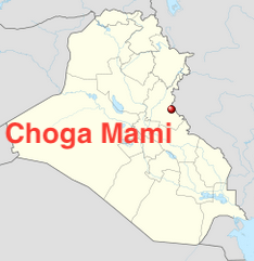
Choga Mami is one of the most important Neolithic sites in Iraq for understanding how farming communities adapted to a dry, marginal-rainfall environment through water management. It is particularly valuable because it brings together several themes that rarely occur so clearly at one site: mudbrick houses, tripartite architecture, irrigation canals, cereal agriculture, livestock, long-distance obsidian exchange, elaborate female figurines, pottery, and an unusually early transition toward the Ubaid world.
It was not directly on the Tigris. Instead, it stood in the Mandali region of eastern Iraq, near the Iranian frontier, at the western foot of the Zagros foothills, where the small Gangir River emerged from the hills onto the plain. Mandali is about 125 km northeast/east-northeast of Baghdad as the crow flies.
The really important story is therefore: Zagros foothills to Gangir water to irrigation to wheat/barley/flax to livestock to permanent mudbrick settlement to increasingly complex architecture
Choga Mami lies in Diyala Province, in the Mandali region of eastern Iraq, close to the Iranian border
Its approximate published coordinates are 33°53′N, 45°27′E. About 125 km northeast/east-northeast of Baghdad. Close to the modern town of Mandali, and Iranian frontier. On the eastern margin of the Mesopotamian plain; at the foothills of the Zagros; near the Gangir River. On an ancient route connecting Mesopotamia with Iran. It occupied the foothill/alluvial-fan environment east of the Diyala plain, where water descended from the Iranian hills.
The surviving mound was relatively low but extensive
The excavators described Choga Mami as approximately 350 × 100 m, although severe erosion has destroyed portions of the upper settlement. The archaeological settlement was therefore more like a large village or small town than an isolated farmhouse. The site was heavily eroded, which creates a major problem: we do not possess the entire occupational sequence. Some of the latest buildings and upper levels were lost. It becomes very important when discussing abandonment.
The principal excavation was an international project led by: Joan Oates, British archaeologist; and, David Oates, Archaeologist and architect
The first excavation season ran from: 2 December 1967 – 26 February 1968. Teams have incluuded: Iraqi archaeological authorities + British archaeologists + American institutional funding + Cambridge archaeobotanical/zooarchaeological research + Russian specialists.
Choga Mami is principally a: Pottery Neolithic / Samarra-period settlement
The surviving occupation belongs primarily to the 6th millennium BC, especially the Samarra cultural horizon.
However, there is an important qualification. The nearby Mandali region contains Jarmo-related material, including flints and pottery that may date as early as approximately 6750 BC. Excavators specifically noted that they had not recovered securely earlier occupation at Choga Mami itself.
Broad archaeological sequence is approximately: 6th millennium BC: Main Samarra occupation; to, later 6th millennium BC: Late Samarra; to, 5th millennium BC Samarra → Hajji Muhammad/Ubaid transition; to, later material: Halaf and Ubaid-related material
A radiocarbon measurement from a Transitional Samarra/Hajji Muhammad level produced an old uncalibrated date of: 4896 BC (BM-483; 6846 ± 182 BP). The excavators’ initial chronological framework placed the principal settlement approximately around 5500–5000 BC, although subsequent chronological calibration and ceramic correlations have complicated the exact dates.
Excavators recovered: classical Samarra pottery; Late Samarra; a Samarra/Hajji Muhammad transitional assemblage; Late Halaf pottery in a later well; and, Hajji Muhammad/Ubaid material
The upper part of the mound had been destroyed by erosion, however, so the later sequence is incomplete.
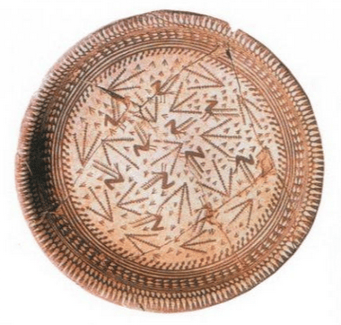
The principal ceramic tradition was: Samarra painted pottery
The site also produced: painted pottery; incised pottery; plain wares; Late Samarra material; Transitional Samarra/Hajji Muhammad pottery; Halaf pottery; and, later Ubaid-related ceramics.
The pottery is especially important because Choga Mami sits at a cultural crossroads between: northern Mesopotamia, and southern Mesopotamia. It also shows connections toward Iran.
Archaeobotanical assemblage is particularly impressive
Choga Mami produced evidence for: Wheat: einkorn, emmer, and bread wheat. Barley: naked six-row barley; and hulled two-row barley. Other cereals/plants: large-grained oat, rye-grass, clover and linseed/flax
The range demonstrates that the inhabitants were practicing a fully developed winter agricultural system, not merely experimenting with cultivation.
The plant assemblage includes: lentils, peas / large-seeded peas, as well as other wild grass and plant remains
This gives us an important agricultural combination: wheat + barley + pulses + flax. A very sophisticated early farming package.
Flax/linseed occurs alongside the cereals and legumes
Its presence is one of the reasons archaeobotanists have argued that the agricultural system had access to more water than ordinary rainfall alone would have provided. This is one of the strongest pieces of evidence linking the plant assemblage to the irrigation system.
Pistachio as a gathered resource, not necessarily a cultivated orchard
The archaeological interpretation is that they came from higher-elevation woodland/foothill environments. This is a very useful environmental clue. It means Choga Mami’s inhabitants were exploiting at least two ecological zones: Irrigated plain, wheat + barley + flax + legumes; and, Zagros foothills, pistachio + wild plants + hunting. This is exactly the kind of multi-zone resource strategy that makes the site interesting from an ecological-architecture perspective.
Sheep and goats
Choga Mami had a well-developed domestic animal economy. Evidence includes: sheep, goats, cattle, pigs and dogs. This is important because Choga Mami represents a very broad Neolithic livestock package rather than simply sheep-and-goat herding.
Dog remains are reported among the domesticates
That is particularly interesting because the settlement also continued to rely upon hunting. The dog therefore potentially participated in: herding; hunting; settlement protection; and, companionship. We cannot assign a particular function archaeologically, but its presence is secure in the broader faunal interpretation.
Pigs and cattle
Choga Mami is notable for its domestic cattle and pigs, as well as sheep and goats. Kent Flannery noted that domestic pigs represented just under 8% of the fauna in the relevant assemblage. Domestic cattle are particularly significant in the context of irrigation agriculture because they potentially provided: meat; hides; and, traction. The excavators suggested that the presence of cattle might eventually be connected with the development of animal traction, although direct evidence for ploughs is absent. Ox traction is possible but unproven.
Agriculture did not eliminate hunting
The faunal assemblage includes wild animals such as gazelle; deer; wild boar; wild sheep/goat; onager; wolf; and fox. The site therefore represents a mixed agricultural–pastoral–hunting economy. This is particularly interesting because the increase in gazelle remains has been interpreted by some researchers as potentially reflecting environmental/agricultural problems.
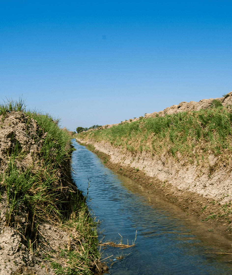
Irrigation: Choga Mami’s great claim to fame
This is the feature that makes Choga Mami famous. The settlement had artificial channels associated with the Samarra occupation. Some channels were found along the north side of the mound, and an ancient canal approached the settlement from the direction of Mandali, where water could be obtained from the Gangir. The system appears to have used the natural slope of the alluvial fan. The basic engineering concept was remarkably simple: capture water higher up, divert it sideways, distribute it across agricultural land, and allow drainage lower down. It is a brilliant low-energy hydraulic system.
Was it really the world’s first irrigation?
You will often see Choga Mami described as having the earliest known canal irrigation, around 6000 BC. That is a useful shorthand.
Choga Mami provides some of the earliest strong archaeological evidence for artificial canal/channel irrigation in Mesopotamia. The evidence is especially significant because both: physical channels, and water-demanding crops occur together. This is stronger than simply finding an isolated ditch.
The irrigation system was probably collaborative
Some reconstructions describe channels extending for several kilometres. Even a relatively modest canal system requires surveying; digging; maintenance; clearing sediment; controlling water; and coordinating fields. This implies a level of collective labor organization beyond an isolated household. That is a major architectural/social point. The architecture was not simply responding to climate individually. The community was beginning to modify the landscape itself.
Climate: what was it like?
Modern Choga Mami lies in a semi-arid/marginal rainfall environment. Published descriptions place reliable rainfall around roughly 200–300 mm annually, depending on the climatic dataset and boundary used. That is important. Rainfall alone is marginal for the agricultural package documented archaeologically. Yet the inhabitants were growing: wheat; barley; flax; lentils; and peas. The simplest explanation is that: river/floodwater management supplemented rainfall.
Was the Holocene climate wetter?
Probably—but we should avoid presenting Choga Mami as a simple “wet Sahara” type of case. The broader Near East experienced substantial Holocene climatic fluctuations. At Choga Mami, the archaeological evidence itself tells us something particularly useful: the ancient agricultural system had access to more water than the modern rainfall regime would normally provide. Hans Helbaek specifically interpreted the botanical assemblage as evidence for irrigation. The ancient inhabitants were therefore not necessarily living in a dramatically wetter landscape. They were engineering water into a dry landscape. That is arguably the more interesting story.
Salinization
Irrigation creates a problem: salt. In arid environments, water evaporates from soils and leaves salts behind. Choga Mami is interesting because the site’s landscape offered a relatively unusual drainage advantage. The Mandali region had differences in elevation between watercourses, potentially allowing excess water to drain away rather than accumulating indefinitely in the fields. This may explain why irrigation was possible here before the enormous salinization problems that later affected portions of southern Mesopotamia. It should be treated as a hypothesis/problem under discussion, not as a proven cause of abandonment.
Choga Mami’s architecture is one of its great strengths
The houses were: rectangular; mudbrick; multi-room; carefully organized; frequently arranged around central halls; and strengthened with external buttresses. The characteristic buildings often had: two or three rows of small rooms on either side of a central hall. This is the classic tripartite plan.
What were the bricks like?
Choga Mami is particularly interesting because its bricks were not simply the standard flat mudbrick seen at many later sites. The buildings used large elongated/cigar-shaped mudbricks, sometimes around 0.6–0.9 m long and 0.12–0.18 m in diameter, laid in alternating orientations. This produced strong, highly characteristic walls.
External buttresses occurred at: corners; wall junctions; and structurally important locations. Later, the buttresses appear to have become partly decorative rather than purely structural. That is an excellent architectural evolution story: structural reinforcement, architectural convention and visual identity.
One of the largest excavated buildings was approximately: 10 × 7 m with approximately 12 rooms arranged in three rows
That is already far removed from the earliest single-room Neolithic house. The architecture implies: storage; food preparation; craft activity; sleeping/living spaces;
circulation; and, perhaps livestock-related functions.
Was there a communal or ritual building?
No unequivocal temple has been identified. This is an important contrast with sites such as Göbekli Tepe. At Choga Mami, the evidence is dominated by domestic/settlement architecture. There were: large houses; multi-room structures; central halls; storage spaces; and, a settlement entrance/watchtower. There is no securely identified monumental communal building comparable to a specialized ritual complex. However, ritual behavior is clearly present in the material culture.
Figurines: Choga Mami produced some remarkable female terracotta figurines
The excavators regarded them as especially important because their elongated heads and hairstyles appeared to anticipate some later Ubaid “lizard-headed” figurines.
These figurines are therefore important for two reasons: they tell us about symbolic/ritual behavior; and, they provide a possible link between Samarra and Ubaid traditions. But, as with the “goddess” interpretations at Tell es-Sawwan: we should not automatically call them fertility or mother-goddess figures. Their exact social meaning remains unknown.
Other unusual clay objects
The site produced some fascinating small objects. These include: pendants; clay discs; figurine fragments; a cylindrical seal-like object; “pottery wheels”; and, other baked-clay objects. One cylindrical object had an incised herringbone pattern and was the only example of its kind reported from the excavation. The “seal-like” object is particularly interesting, but it is better not to call it a confirmed administrative stamp seal.
Game pieces or tokens?
No confirmed board game. There are geometric clay objects and objects sometimes classified as tokens, but their function is uncertain. The excavated material also included pottery wheels/discs, which could have had multiple functions. Therefore: Gaming pieces: unproven; Clay tokens/geometric objects: possible; Administrative accounting system: not demonstrated. This is worth keeping separate from the much later Mesopotamian evidence for formal accounting.
Weapons and hunting equipment
Chipped-stone assemblage included: sickle blades; blades; scrapers; cores; and other cutting tools. There was also substantial ground-stone technology. The site’s hunting economy provides indirect evidence for weapons, particularly projectile technology, but Choga Mami is not principally famous for a large weapons assemblage. Its most important technological story is instead: agricultural tools + hunting tools + composite/stone technology + irrigation.
Flint
Lots of it. The site produced a substantial flint industry. Cambridge’s Museum of Archaeology and Anthropology, for example, records excavated Choga Mami collections containing flint blades, blade cores and waste, collected by Joan and David Oates during the 1967–68 excavation.
Peder Mortensen subsequently studied the Samarran flint and obsidian sequence from the site. The toolkit includes agricultural implements, especially sickle elements.
Obsidian: yes, and this is important for trade
Obsidian is definitely present. Peder Mortensen specifically published a study entitled: “A Sequence of Samarran Flint and Obsidian Tools from Choga Mami.” Obsidian is significant because it does not originate locally in the Mandali plain. Its presence demonstrates long-distance exchange involving the wider: Zagros–Iran–Mesopotamian interaction network. Provenance research has identified Choga Mami as one of the Diyala-area sites participating in broader obsidian circulation across the Zagros and Iranian highlands.
Was the flint local?
Much of the flint was probably obtained from regional sources, although not every artifact has been geochemically sourced. The archaeological assemblage includes extensive flint-working debris and cores, suggesting that at least some production occurred locally or regionally rather than all tools arriving as finished imports. This makes a useful contrast: ordinary cutting technology = locally accessible stone versus: obsidian = prestige/technologically desirable imported material.
Woodworking and doors
No substantial wooden doors have survived. That is unsurprising in an archaeological environment where organic material is poorly preserved. But the architecture provides evidence for: substantial wall construction; doorways; central halls; carefully organized circulation; and, roofs requiring structural organic material.
The presence of cattle and possible traction technology also raises the possibility of substantial woodworking, but: no securely identified wooden plough or door survives from Choga Mami.
Doors: architectural doorways present; wooden leaves not preserved
Woodworking: probable/necessary, but direct evidence limited
Reed, clay and mudbrick
The construction system was overwhelmingly earth-based. The local environment provided: Mud/clay: bricks, plaster and pottery
Reed: roofing/matting/baskets
Wood: roof structure/tools
Stone: cutting and grinding
This is precisely the sort of locally adapted construction system that makes Choga Mami useful for modern architecture research.
Was there evidence of storage?
The architecture contains numerous small rooms that have been interpreted as possible storage rooms/granaries. Some excavated pits also appear originally to have been designed for storage before being reused as rubbish deposits. One such pit eventually contained the skeletons of several onagers. So the architectural system probably incorporated: production → processing → storage → household consumption. Rather than simply immediate consumption.
A remarkable agricultural system
The Choga Mami system can be reconstructed approximately as: Gangir River,
main canal, smaller channels, fields, wheat + barley + flax + legumes, livestock and settlement. This is an early example of what we might now call landscape-scale architecture. The architecture did not stop at the walls of the house. The canal itself was architecture.
The climate–architecture relationship
Choga Mami shows that architecture can respond to climate at several scales.
House scale. Mudbrick provides thermal mass.
Settlement scale. Compact multi-room houses reduce exposed surface area.
Landscape scale. Canals redirect water.
Agricultural scale. Irrigation makes cereal production possible.
Regional scale. The settlement connects the Zagros foothills with the Mesopotamian plain.
Thus: climate adaptation was not just thick walls. It was: water + soil + plants + livestock + buildings + labor.
Did they have fruit trees?
The evidence is much weaker than for cereals. Securely demonstrated: Pistachio nuts — YES. Probably gathered from the foothills/highlands. Not securely demonstrated: Almond — no, Fig — no, and Date palm — no secure Neolithic cultivation evidence. This is an important difference from later Mesopotamia, where date-palm agriculture becomes enormously important.
Choga Mami’s food system was still overwhelmingly cereal + pulse + livestock + wild-resource based.
How many occupations?
Excavated settlement had multiple Samarra building levels/phases, followed by a Samarra/Hajji Muhammad transitional phase. But the site was not abandoned and reoccupied in a simple series of discrete episodes. Instead, there appears to have been substantial architectural continuity. Buildings were repeatedly constructed over earlier structures, and later phases modified the settlement. The uppermost occupation was badly eroded. Therefore I would record: Multiple building phases; continuous/recurrent occupation through the Samarra sequence; later occupation partly destroyed by erosion.
Eventually it was abandoned
We cannot see the entire abandonment process. This is one of the places where caution is particularly important. The excavators explicitly noted that later occupation existed but was lost through erosion. The latest preserved material included the Samarra/Hajji Muhammad transition, while higher levels contained evidence of later Halaf and Ubaid-related activity. Therefore, we cannot say: “Choga Mami was abandoned permanently in 4800 BC.” That would overstate the evidence. A better formulation is: The exposed Neolithic settlement eventually ceased to be occupied, but the upper/later occupational history was substantially destroyed by erosion; later Halaf and Ubaid-related material demonstrates that the site or immediate mound was revisited/occupied after the main Samarra settlement.
One of the site’s most interesting chronological features was the Halaf connection
A later well contained late Halaf polychrome pottery comparable to material from Arpachiyah, together with material that appeared to have Iranian connections. There was also a later Ubaid well containing Hajji Muhammad/Ubaid-related pottery. So Choga Mami was not isolated. It was part of a cultural corridor connecting: Mesopotamia, Zagros, Iran, and eventually Samarra, Ubaid and Halaf.
Choga Mami’s most important archaeological contribution
The great importance of Choga Mami is not simply: “They had canals.” It is the combination of: 1. Marginal rainfall. Agriculture was environmentally risky.
2. Water engineering. The inhabitants redirected river water.
3. Farming. Wheat, barley, flax and pulses.
4. Herding. Sheep, goats, cattle, pigs and dogs.
5. Hunting. Gazelle, deer, onager and other wild animals.
6. Architecture. Large, multi-room mudbrick houses.
7. Craft. Pottery, flint, ground stone and figurines.
8. Trade. Imported obsidian.
Regional interaction
Connections with Iran, Halaf and Ubaid traditions. This makes Choga Mami a systems-level Neolithic settlement. Two very complementary Neolithic case studies: Tell es-Sawwan = architecture + burial + enclosure; and, Choga Mami = architecture + water engineering + agriculture.
Choga Mami is one of the strongest sites for “Neolithic architecture as climate adaptation.” The sequence is: Zagros foothills, seasonal/perennial water, canal, irrigated field, wheat/barley/flax/pulses, livestock, surplus, storage, multi-room mudbrick architecture, coordinated labor and larger settlement
That is a remarkably early example of infrastructure shaping civilization. And unlike monumental architecture, the infrastructure was largely invisible: the canal was as important as the house.
References: Oates, J. (1969). Choga Mami, 1967–68: A Preliminary Report. Iraq 31(2), 115–152. This is the fundamental excavation report, covering architecture, pottery, figurines, tools, stratigraphy and the early irrigation evidence.
Helbaek, H. (1972). Samarran Irrigation Agriculture at Choga Mami in Iraq. Iraq 34(1), 35–48. This is the essential archaeobotanical/agricultural reference for wheat, barley, flax, legumes and irrigation.
Oates, J. (1972). A Radiocarbon Date from Choga Mami. Iraq 34(1), 49–53. Important for the chronology of the Samarra/Hajji Muhammad transitional phase.
Mortensen, P. (1973). A Sequence of Samarran Flint and Obsidian Tools from Choga Mami. Iraq 35(1), 37–55. Essential for the lithic and obsidian evidence.
Oates, D. & Oates, J. (1976). The Rise of Civilization. A broader synthesis placing Choga Mami within the development of irrigation and Mesopotamian civilization.
Flannery, K. V. (1978). Work on the faunal evidence and early agricultural economies, including Choga Mami’s domestic cattle, sheep, goats, pigs and dogs.
Leave a Reply