<home # start here # guides # builds # services # shop # about # categories>
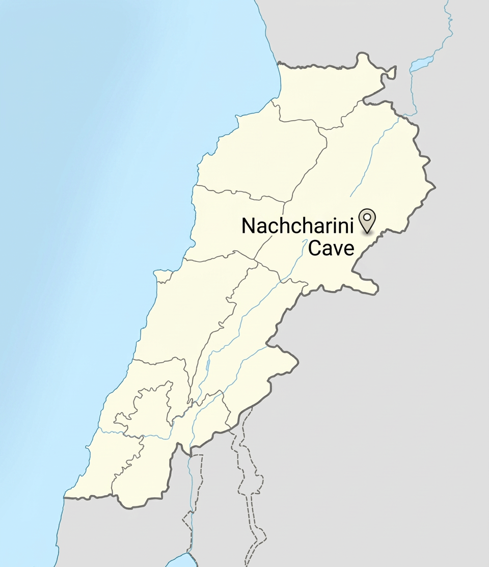
Nachcharini Cave, also written Mugharat an-Nachcharini or Nahcharini, is one of the most unusual prehistoric sites in Lebanon. It is not a large Neolithic village like Tell Labwe South. It is not a monumental ritual centre like Göbekli Tepe. And, it does not represent the classic image of the first farming village on the Tigris or Euphrates. Instead, the site preserves something arguably just as important: a high-altitude hunting camp used by people who were living through the transition from hunter-gathering to farming.
At more than 2000 metres above sea level, it is the highest known excavated early Neolithic site in the Levant. It sits in the Anti-Lebanon Mountains, near the modern Lebanese-Syrian border, amid karst sinkholes, steep-sided valleys and seasonal snowfields. [1][2]
The recent reanalysis of the site has transformed its significance. Rather than treating Nachcharini as simply a small cave with some Neolithic tools, archaeologists now see it as evidence for a specialized, repeatedly used hunting station, probably occupied seasonally for roughly two centuries around the beginning of the Pre-Pottery Neolithic A (PPNA). [1]
Nachcharini lies on the ʿArd al-Kichek/Ard el-Kishek plateau of the Anti-Lebanon Mountains, in northeastern Lebanon, close to Syria. The commonly published coordinates are approximately: 34°04′39″ N, 36°20′52″ E, and the elevation is approximately 2,100–2,120 m. [1][3] For comparison, many of the famous early farming communities of the Levant were located in: river valleys, lake margins, foothills, low plateaus, or relatively fertile plains. Nachcharini was high in the mountains. The surrounding landscape consists of limestone karst, with sinkholes, dolines, narrow valleys and steep slopes. These landforms created excellent habitat for wild sheep, goats and gazelle. [1]
Especially compared with the major lowland settlements. It was difficult to reach
The cave sits around 2.1 km above sea level. The plateau also receives substantial winter snowfall, and snow can remain until May or June. [1]
A plausible visitation pattern could have been fall, climb into the mountains, hunt, process animals and return to lower settlements.
The 2003 survey even suggested that the surrounding mountains may have been difficult or impossible to occupy during the harshest winter months. [4]
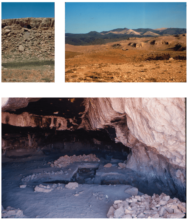
It was discovered during archaeological exploration of the Anti-Lebanon, not literally by a random hiker happening to fall into a cave
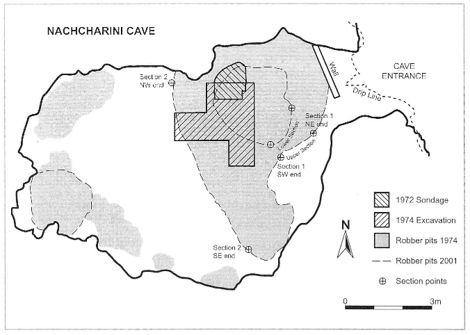
Jacques Besançon discovered the cave around 1970. Bruce Schroeder subsequently investigated and excavated it in 1972 and 1974. [1] Schroeder’s work formed part of a much larger University of Toronto investigation of prehistoric occupation in Lebanon’s Beqaa and Anti-Lebanon regions. [1][5] The work was interrupted by the Lebanese Civil War in 1975.
In 2001, Alex Wasse and colleagues returned as part of the Nachcharini Highland Survey Project
Working with the Directorate General of Antiquities, the Council for British Research in the Levant and the Museum of Lebanese Prehistory at Université Saint-Joseph. They relocating Schroeder’s sites, obtaining accurate GPS coordinates, surveyed the plateau, investigated the environmental setting, and assessed the condition of Nachcharini Cave. [5] They relocated 19 of Schroeder’s 23 previously identified prehistoric sites and discovered 39 additional sites. The wider landscape consequently turned out to be much more archaeologically important than the cave alone. [5]
Nachcharini is approximately 14 km straight-line from the Labweh/Labweh spring area, one of the principal headwater zones of the Orontes
So the Orontes drainage is extremely close in geographical terms. But it is not a riverside settlement. It is a mountain hunting station overlooking a landscape that ultimately drains toward the Orontes and the Beqaa.
The straight-line distance between Nachcharini and Byblos is approximately: 65 km however its not flat
A prehistoric traveller would have had to cross the Mount Lebanon/Anti-Lebanon mountain systems and the Beqaa, rather than simply walking across a flat plain. It could have been doable 3–5 days on foot. And, depending upon route, season, baggage, snow and whether travellers were moving with animals. But Nachcharini belonged much more immediately to the Beqaa–Anti-Lebanon–Syrian interior network than to the coastal world.
The nearest major Euphrates corridor in Syria is approximately 200–250+ km away, depending upon which section of the river is used
Nachcharini’s tool traditions belong to a wider PPNA world extending from the Levant into northern Syria and the Euphrates region.
The surrounding Anti-Lebanon mountains and area is extraordinarily rich. Important nearby or regionally related prehistoric localities include: (Ain Chaub, TLS, Saaide, Yabrud, Baaz cave, & Nebe Mend)
Ain Chaub. A highland rock shelter overlooking the Beqaa, at approximately 1,280 m. It produced Epipalaeolithic material. [6]
Tell Labwe South. The major Neolithic village in the northern Beqaa discussed in the previous study. It is approximately 14 km away in straight-line distance from Nachcharini. Tell Labwe could have been one of the lower-elevation settlement zones connected to the mountain hunting system represented at Nachcharini.
Jebel Saaidé/Saaidé. An important Epipalaeolithic/Natufian settlement area in the Beqaa.
Yabrud. Across the Anti-Lebanon in Syria, with an exceptionally long Paleolithic sequence.
Baaz Cave. Another important prehistoric cave locality in the Syrian Anti-Lebanon region. And,
Tell Nebe Mend. A major prehistoric locality farther north in the Beqaa/Orontes region.
There is no evidence that people constructed the cave. Nachcharini is a natural limestone cave, situated within a rugged karst landscape
They inherited a ready-made shelter. No substantial permanent building has been demonstrated. A big differences between Nachcharini and Tell Labwe.
The archaeological evidence instead represents occupation surfaces inside the cave
The 2003 survey described the deposits as approximately five major stratigraphic units. Layer 4 was a compact reddish silty deposit containing multiple occupational horizons and hearths in its lower levels. [4]
In a sense it was semi subterranean architecture. The cave is naturally subterranean/rock-sheltered. People created and maintained occupation surfaces within the cave and repeatedly used particular areas. Rather than human built underground architecture.
Hearths are one of the clearest pieces of domestic technology
Layer 4 contains occupational horizons and hearths, especially in its lower levels. [4] The dense PPNA layer also contained: charcoal, animal bone, stone tools, and, other occupation debris. [1][4]
There is no convincing evidence for: chairs, formal beds, built-in benches, cupboards, tables, or other recognizable furniture
People could have slept on: animal skins, plant material, mats, grasses, or simple bedding. But such material would rarely survive. Furniture was probably mostly portable and perishable.
Calling Nachcharini a “settlement” can be misleading. Because it was probably a short-term, task-specific hunting camp
The 2020 reanalysis concluded that it was probably used intermittently over roughly two centuries rather than continuously occupied. [1] Instead, the landscape probably contained: large residential villages, small temporary camps, specialized hunting stations, seasonal resource areas and travel corridors.
Was there a communal or ceremonial building? At approximately the same time, some PPNA communities elsewhere were investing heavily in monumental architecture. Nachcharini demonstrates that other people were doing something very different: moving into difficult environments to acquire particular resources
The 2003 environmental reconstruction suggested that the Anti-Lebanon region could support a diverse range of plants. The surrounding environment was botanically rich
Included was: oak woodland, juniper, wild almond, wild pear, wild plum, hawthorn, grasses, wild cereals, and legumes. [4]
Schroeder’s excavations also recovered carbonized: almond, pistachio, juniper, and, pear material. [4]
A sheep and goat story. The faunal assemblage is overwhelmingly dominated by caprines
The minimum number of identified animals in Layer 4d includes: wild sheep — at least 7, wild goat — at least 2, additional sheep/goat individuals — 5, mountain gazelle — 5 and red deer/deer — 2. [1] The pattern suggests wild-sheep hunting was the primary purpose of the camp. The hunters were bringing animals into the cave and processing them.
Deer remains may represent animals butchered elsewhere or remains introduced through other processes, and are different. [1]
The unusual dominance of wild sheep led 2020 researchers to raise the possibility of incipient herd management [1]
But the evidence is not strong enough to call the animals domesticated. It was probably wild sheep, perhaps subject to very early management or controlled exploitation. The clear domestication of sheep belongs later in the PPNB process.
A 2025 stable-isotope study by Laura C. Eastham and Stephen Rhodes examined sequential carbon and oxygen isotope signals in wild sheep teeth from Nachcharini. The purpose was to reconstruct seasonal altitudinal movement [7]
The research uses the chemistry of tooth enamel to investigate where the sheep lived during different stages of their lives. Animals were moving through different elevations seasonally, and the hunters could have followed or intercepted those movements. This helps explain why a hunting camp at 2,100 m made sense. They were exploiting an elevation-dependent seasonal ecosystem
The PPNA fauna includes: Wild sheep, Ovis cf. orientalis; Wild goat, Capra aegagrus, possibly Capra ibex; Mountain gazelle, Gazella gazella; Red deer, Cervus elaphus; and, Possibly fallow deer, Dama mesopotamica
The older regional reports also indicate equids among the wider prehistoric fauna of the Anti-Lebanon. [4][6]

Tool assemblage is highly specialized. The dominant tools include: El-Khiam points, Hagdud truncations, Bladelets, Grinding stones, & Bone awl
El-Khiam points. Small, side-notched projectile points.
Hagdud truncations. Distinctively truncated blade/bladelet pieces.
Bladelets. Many were used in hunting equipment.
Borers. Three examined micro-borers show use-wear consistent with drilling stone. [8]
Grinding stones. Fragments of quartzite grinding stones were recovered.
Bone awl: A bone awl was among the few non-lithic tools reported. [4]
The lithic evidence suggests there was little primary stone-core production at Nachcharini. And, that they repaired their weapons in the cave
Hunters arrived with tools, used them, broke them, replaced damaged points, recycled fragments, and retooled their hunting equipment. [1] It is essentially a prehistoric field workshop.
The Anti-Lebanon area provided high-quality limestone, flint/chert sources, quartzite, timber, nuts, wild fruits, grasses, wild sheep, goats, deer, gazelle, and seasonal water
It was a excellent resource landscape.
Where Nachcharini becomes much bigger than a Neolithic site. What happened during the Paleolithic?
The 2001 Anti-Lebanon survey found evidence for the Middle Paleolithic in the wider landscape. [5] The cave itself has indications of earlier prehistoric activity, although the chronology and identification of the earliest material are less secure than the PPNA sequence.
The 2003 survey described: Upper deposits. Historic and mixed prehistoric material.
Layer 4. Strong Neolithic occupation.
Layer 5. A deeper red clayey cave earth containing: bone, flint, large blades, flakes, carinated burins, and upper-horizon geometric microliths interpreted as potentially Natufian. [4] Later researchers have been more cautious about the Natufian attribution: the 2001 reinvestigation did not find convincing in-situ Natufian material in the cave. [2][6]
Nachcharini lies within a landscape used from the Paleolithic through the Neolithic, but the strongest securely demonstrated occupation at the cave itself is PPNA.
The surrounding Anti-Lebanon is geologically rugged and contains: cliffs, sinkholes, dolines, steep slopes, and rockfalls
But no specific catastrophic landslide has been demonstrated as the cause of abandonment. The larger problem for the archaeology has been human disturbance and looting.
Nachcharini sits directly within one of the most important climate transitions in human history, the Younger Dryas
The PPNA developed after the end of the Younger Dryas, when climate conditions became warmer and generally more favourable for plant productivity.
It was easy to overlook that snow was apart of the environment
At 2,100 m, Nachcharini would have experienced: heavy winter snow, prolonged snow cover, very cold winters, short growing seasons, and, strong seasonal changes. The plateau could remain snow-covered into May or June. [1]
It was an environmental paradox
During the warm season, the high plateau could remain productive after lower elevations became drier. The researchers suggest that high-altitude vegetation could provide grazing resources into late summer. [1]
Important lessons for archaeology: An archaeological site does not stop producing information when excavation ends
The original excavation happened in: 1972–1974. Then war interrupted the project. Decades later old bones, old stone tools and old excavation notes were subjected to: AMS radiocarbon dating, modern zooarchaeology, lithic use analysis, SEM examination, and eventually stable-isotope analysis. Suddenly the old excavation could answer questions that archaeologists in the 1970s could barely ask.
The site shows social practices may have been highly variable
Absence of a major burial tradition is informative. Compare Tell Labwe: people buried beneath houses. Jericho: burials and plastered skull traditions. Kfar HaHoresh: specialized funerary/ritual landscape. And, Nachcharini: no comparable funerary complex demonstrated but they were hunting animals. This helps show that Neolithic social practices were highly variable. There was no single “Neolithic religion” or single “Neolithic settlement model.”
The site is another ‘architecture of survival’ model
At Tell Labwe: humans constructed the shelter. At Nachcharini: humans selected and organized a natural shelter. That is still architecture. The mountain provided: walls, roof, thermal mass, protection from wind, a defensible entrance, and a place to contain fire. Humans added: hearths, occupation surfaces, tools, meat processing, maintenance, and, repeated spatial use. A great model for: Architecture by selection rather than architecture by construction.
A useful modern analogy might be: base village was the headquarters. And, Nachcharini the seasonal field camp
The village communities could send specialized groups into the mountains.
An archaeological “toolbox”: Need versus Archaeological solution
Shelter Natural limestone cave
Fire Hearths
Hunting Khiam points
Composite weapons Khiam points + Hagdud truncations
Retooling Bladelet recycling
Cutting Retouched blades
Drilling Micro-borers
Food processing Quartzite grinding stones
Hide/plant work Bone awl
Meat Wild sheep/goat/gazelle/deer
Seasonal water Mountain environment
Storage/carrying Probably perishable containers
Winter protection Cave + highland landscape
Navigation Anti-Lebanon mountain corridor
If Tell Labwe teaches us: “The Neolithic village was becoming a machine for producing food.” Nachcharini teaches us: “The Neolithic was still a world of hunters, mountains and seasonal movement”
Nachcharini captures a transitional world beautifully.
Nachcharini Cave is evidence that the first Neolithic people were not abandoning the old world of hunting. They were adding new economic strategies to it
At the same time people elsewhere were establishing substantial villages, cultivating cereals and building communal architecture, people were climbing 2,100 metres into the Anti-Lebanon mountain to hunt wild sheep. The “Neolithic Revolution” was not one revolution. It was a network of different adaptations.
Nachcharini Cave versus Tell Labwe South
Elevation ~2,100 m ~950 m
Environment High mountain Beqaa Valley
Main period PPNA Late PPNB → Pottery Neolithic
Settlement Seasonal camp Permanent village
Architecture Natural cave Built houses
Mudbrick No demonstrated Yes
Stone walls No substantial house walls Yes
Lime floors No major architectural sequence Yes
Hearths Yes Yes
Agriculture Not demonstrated as primary activity Strong evidence
Sheep/goat Wild, hunted Domesticated/herded
Cattle No major evidence Yes
Pig No major PPNA focus Yes
Hunting Dominant Secondary
Fish No major evidence Yes
Cereals Environmental resources Wheat/barley
Legumes Not established Lentils/peas
Burials No major documented complex Under-house burials
Ritual architecture None identified None monumental
Obsidian No major defining assemblage Major long-distance resource
Function Hunting/foraging station Farming village
A strengthening argument for treating the Neolithic as a landscape system rather than simply a period of architecture.
Nachcharini Cave is one of the clearest archaeological demonstrations that the beginning of the Neolithic was not the end of the hunter—it was the beginning of a much more complicated landscape economy in which farmers, hunters, mountain camps and permanent villages could all belong to the same human system.
References: [1] Rhodes, S., Banning, E. B., & Chazan, M. (2020). “Mugharat an-Nachcharini: A specialized sheep-hunting camp reveals high-altitude habitats in the earliest Neolithic of the Central Levant.” PLOS ONE, 15(1), e0227276. This is currently the most important modern synthesis of the PPNA occupation, lithics, fauna and radiocarbon chronology.
[2] Garrard, A. N. (2017). “The Epipalaeolithic and Pre-Pottery Neolithic of Lebanon.” In Quaternary of the Levant. Cambridge University Press. Garrard discusses Nachcharini’s position within the wider Lebanese Epipalaeolithic and Neolithic sequence and emphasizes the specialized PPNA character of the site.
[3] Archaeological geographical records place Nachcharini at approximately 34°04′39″ N, 36°20′52″ E, on the Nachcharini Plateau at approximately 2,100 m.
[4] Garrard, A., Pirie, A., Schroeder, B. & Wasse, A., with contributions by Clarke, J., Haïdar-Boustani, M., Rhodes, S. & Yazbeck, C. (2003/2004). “Survey of Nachcharini Cave and prehistoric settlement in the northern Anti-Lebanon Highlands.” Bulletin d’Archéologie et d’Architecture Libanaises 7, pp. 15–48. This is particularly important for the site’s environmental setting, stratigraphy, hearths, plant remains and wider highland survey.
[5] Musée de Préhistoire Libanaise, Université Saint-Joseph. Archaeological Survey within the Anti-Lebanon Mountains (2001). The museum reports the relocation of Schroeder’s sites and the discovery of 39 additional prehistoric sites; the survey identified Middle Paleolithic through Chalcolithic/Early Bronze Age evidence in the region.
[6] Copeland, L. (1991). “Natufian Sites in Lebanon.” In The Natufian Culture in the Levant. Copeland’s work provides important background on Nachcharini and other Lebanese Natufian sites, although later reinvestigation has made the Natufian attribution at Nachcharini more cautious.
[7] Eastham, L. C. & Rhodes, S. (2025). “Up the mountain and back again: Sequential stable-isotope analysis reveals altitudinal migration in wild sheep (Ovis cf. orientalis) from the PPNA site of Nachcharini Cave, Lebanon.” Journal of Archaeological Science: Reports 67, 105366. DOI 10.1016/j.jasrep.2025.105366. This is the important new study using sequential tooth-enamel isotope data to investigate seasonal movement of the wild sheep hunted at Nachcharini.
[8] González-Urquijo, J. et al. Research on micro-drill use in Khiamian/PPNA sites found that examined borers from Nachcharini exhibit use-wear associated with drilling stone.
[9] Pirie, A. (2001). “A Brief Note on the Chipped Stone Assemblage from PPNA Nachcharini Cave, Lebanon.” Neo-Lithics 2001/2, pp. 8–12.
Leave a Reply