<home # start here # guides # builds # services # shop # about # categories>
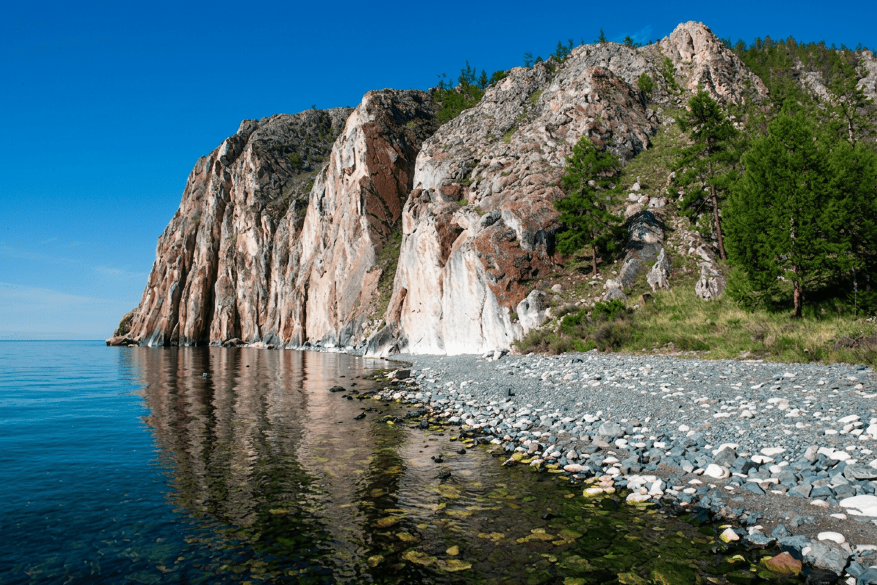
Sagan-Zaba is one of the most interesting prehistoric sites on Lake Baikal—but it is important to separate two things that are often blended together: Sagan-Zaba II, the habitation site, and Sagan-Zaba I, the famous rock-art panel. The habitation sequence begins roughly 9,000 years ago, whereas the surviving rock art is considerably later, beginning around 4,400 years ago and continuing into the first millennium BP. [1–3]
For an architectural study, Sagan-Zaba is particularly valuable because it shows a very different form of Neolithic adaptation from the farming villages of the Fertile Crescent. This was a seasonal hunter-fisher-sealer camp on a severe inland lake, with no evidence that the early inhabitants depended upon wheat, barley, sheep or goats. And, there is an extraordinary fact at its heart: People were hunting Baikal seals here at least 9,000 years ago, and during the Neolithic, seal hunting became extremely intensive. [1]
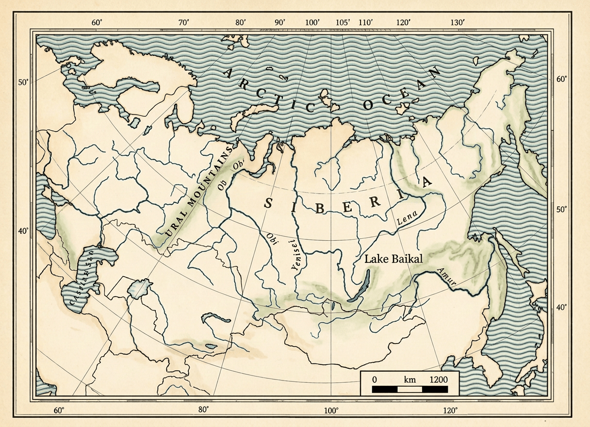
Sagan-Zaba is in southern/eastern Siberia, in the Cis-Baikal region of Irkutsk Oblast, on the western shore of Lake Baikal
The archaeological locality is approximately: 52.6825° N, 106.4760° E. It lies in the Priol’khon’e/Olkhon region, approximately 154 km northeast of Irkutsk and about 13.5 km southeast of the modern settlement of Elantsy. The site is near the mouth of the Angara River, approximately 12 km to the northeast. [2, 4]
Geographically: Irkutsk, Lake Baikal, western Baikal shore and Sagan-Zaba. This puts it firmly in the Baikal-Siberian world, not the Russian heartland.
The site is beside Lake Baikal, in a small sheltered cove. The cove itself is approximately 200 m long, with a narrow cobble-and-pebble beach and a terrace about 150 m wide, cut by small channels [1]
A useful way of thinking about the location is: mountain/forest, small valley, beach and Lake Baikal. The nearby Angara River is an important regional watercourse, but Sagan-Zaba itself is primarily a lakeshore site, not a riverbank settlement. [4] The Angara and Yenisei do eventually flow to the Arctic ocean. So although Sagan-Zaba was thousands of kilometres from an ocean coastline, it was connected to the Arctic drainage system.
Sagan-Zaba lies against the mountainous landscape of the Baikal Rift
The most immediately relevant range is the Primorsky Mountain Range, which rises inland from the western shore. Other major mountain systems around Baikal include: Baikal Mountains; Barguzin Mountains; and, Khamar-Daban Mountains. A regional map shows the Sagan-Zaba/Olkhon area positioned between the Primorsky Range to the west and the major mountain systems around the Baikal basin. [5] The local landscape is therefore much more dramatic than the word “lakeshore” might suggest. The cove itself is a small funnel-shaped valley enclosed by steep hills. [1]
Was this an extreme environment? Yes, in a relative sense
It was not an Arctic tundra settlement, but it was a difficult continental environment. The western Baikal shore experiences: very cold winters; seasonal lake ice; strong winds; relatively dry conditions in the Olkhon region; steep terrain; limited productive farmland; and, large seasonal fluctuations.
Modern vegetation around Sagan-Zaba includes pine and larch, while the slopes nearer the lake include lichen, moss and meadow-steppe vegetation [6]
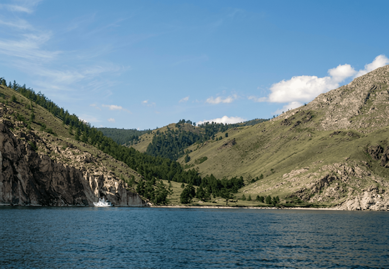
The archaeological researchers explicitly describe the local environment as relatively harsh and suggest that this may help explain why people continued to exploit multiple resources rather than relying on one subsistence strategy. [7] This is an important architectural point. The landscape was difficult for farming but extraordinarily productive for a highly mobile hunter-fisher population.
Perhaps the 1rst thing to get right. Sagan-Zaba was not one settlement
Sagan-Zaba II is a multilayered habitation locality, repeatedly used over much of the Holocene. The excavated sequence includes: Layer Approximate calibrated age Interpretation
VII 9020–8650 BP Early Holocene/Mesolithic
VI 8160–7880 BP Early Holocene
V 6750–6310 BP Middle Holocene
IV 5590–4870 BP Middle Holocene/Neolithic
IIIB 4440–2000 BP mixed later occupation
IIIA 1970–1540 BP Late Holocene
II–I 1230–940 BP Late Holocene [1, 6]

So when we say “the Sagan-Zaba Neolithic,” we are talking about multiple occupations and changing traditions, not one village existing unchanged for thousands of years. And/or, the surviving Sagan-Zaba I rock art panel that came much later.

Did they have houses?
This is where Sagan-Zaba differs sharply from Suchu Island. No clear houses have been identified at Sagan-Zaba II. The extensive 2006–2008 excavation found no evidence of living structures. Instead, the archaeologists identified numerous hearths, concentrations of animal bones, stone artifacts, pottery and other activity areas. [1] Archaeology evidence reports to repeated seasonal camps with hearths and activity areas, but without preserved permanent residential architecture. This is one of the biggest differences from Suchu Island, where substantial pit-house architecture and roof-support postholes have been identified. The absence of structural remains fits remarkably well with the zooarchaeological interpretation that at least some early occupations were short-term spring/summer camps. [8] There could, of course, have been tents, skin shelters, brush shelters or lightweight structures that left little archaeological trace.
So what did their architecture look like?
The best description is: landscape architecture rather than permanent building architecture. The cove itself was the “building.” People selected a location with: access to deep lake water; a beach; a sheltered valley; nearby hills; access to terrestrial animals; access to seals on the lake ice; nearby firewood; and working space for processing animals. The archaeological terrace became a seasonal work floor.
Another useful reminder that: Neolithic architecture does not necessarily mean houses. Sometimes architecture begins with choosing the right landscape.
Hearths were extremely important
The early occupations contain hearths and concentrations of archaeological material around them. Broken animal bones, burned bones, tools and other debris were frequently associated with these features. [8, 9] There is no evidence for a sophisticated central-hearth house comparable to the great houses of Suchu. Instead, the hearths appear to have been part of temporary working/cooking camps. They served several functions: cooking; rendering fat; processing meat; heating; lighting; tool manufacture; possibly hide processing; and social gathering.
The climate nevertheless presented a serious heating challenge
The site was used particularly during spring and summer, when seal hunting was most productive. [1, 8] So the people did not necessarily need to maintain a permanent winter heating system at this particular camp.
Extremely strongly a water-based economy?
But with one fascinating qualification the main aquatic animal was not fish. It was the Baikal seal—nerpa (Pusa sibirica). The 2006–2008 excavations recovered approximately: 74,000 animal remains of which approximately: 16,000+ were Baikal seal remains. More precisely, 16,283 identified specimens—82.8% of the identified assemblage—were Baikal seal. [1, 9] That is an extraordinary archaeological signal.
The earliest occupation at Sagan-Zaba dates to approximately 9,000 years ago
Researchers conclude that seal hunting began there at least 9,000 calendar years ago. [1] During the Middle Holocene, seal exploitation became particularly intense. The site appears to have been used as a spring hunting and processing location, when young seals could be taken around the lake ice. [1] This is a superb example of architecture and settlement organization responding to seasonal animal behaviour.
What did they eat?
The early inhabitants had a broad but strongly aquatic diet. Major resources included: Baikal seal, roe deer, red deer, elk/moose, wild boar, fish, birds, and other mammals. [8]
The early layers produced remains of at least 14 seals; roe deer; red deer; elk; boar; grayling; sturgeon; other fish; and birds. [8] So their diet was not simply “seal, seal, seal.” It was a mixed aquatic–terrestrial economy, although seals could dominate dramatically in particular periods.
Fish were important but not as dominant as the seals
Fishing was definitely practiced. Archaeological evidence includes: composite fishhooks; fishhook shanks; harpoons; a stone fish lure; and other fishing equipment. [9, 10]
Fish included species such as: grayling; sturgeon; whitefish/omul; and other fish. [8, 10] But at Sagan-Zaba itself, fish bones are much less abundant than seal remains. One regional analysis found that fish constituted less than 1% of NISP in the open-coast Sagan-Zaba sample, despite clear evidence of fishing. [11]
Wild plant foods were undoubtedly available in the Baikal environment, but the archaeological case for specific domesticated crops at Sagan-Zaba is absent
We would not put wheat, barley, apples or apricots in a reconstruction of the Neolithic Sagan-Zaba economy.
What about horses, cattle, sheep and goats?
Here chronology becomes essential. Neolithic Sagan-Zaba: No established livestock economy. Late Holocene: Different story. Pastoralists eventually came into the region and used: horses; cattle; sheep; and goats. At Sagan-Zaba II, domestic ungulates become visible particularly in deposits dating to roughly the last 2,000 years. [7, 12] In the earlier of the two Late Holocene domestic-animal components, domestic animals accounted for only about 16% of the assemblage, while fish + seal represented 78.9%. [12] That is an extraordinary result. Even after pastoralism arrived: people continued to eat the lake.
Did they hunt wild animals?
Very much. Early Sagan-Zaba produced roe deer; red deer; elk; wild boar; birds; and seals. There were also traces of: hare; fox; ground squirrel; bear; and wolf. In the broader excavated sequence. [6]
The settlement sat at an ecological intersection: lake, forest, meadow-steppe and mountains
That diversity was a major resource.
Did they have boats?
This is an excellent question, but the evidence is frustrating. There is no preserved Neolithic boat from Sagan-Zaba. Nor is there a securely identified Neolithic boat-building workshop. Nevertheless, the aquatic technology is substantial: harpoons; fishhooks; fishing equipment; seal hunting; and intensive use of a huge lake. [9, 10] It is therefore highly plausible that watercraft were used. But archaeologically: while they certainly lived by and exploited the water excavated boats is not.
Lithic technology is substantial
Assemblage includes: scrapers; arrowheads; knives; adze-like tools; burins; borers; prismatic blade inserts; fish-lure fragments; cores; flakes; and retouched blades. [9, 13]
The early Mesolithic layer VII contained a particularly interesting blade technology: prismatic cores; prismatic blades; blade inserts; burins; scrapers; and retouched flakes. [13]
Flint, chalcedony and other stone
Flint was used. Chalcedony was also present. A Middle Neolithic assemblage from Sagan-Zaba II includes: quartz; chalcedony; flint; prismatic blades; bifacial points; scrapers; and fishing implements. [13, 14] The site’s documented lithic assemblage is dominated by mostlylocal and regional materials.
A spectacular local resource: white marble
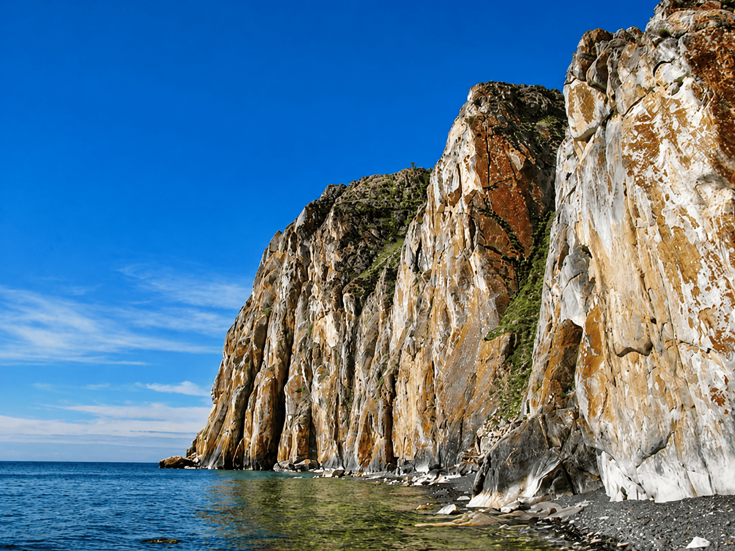
The name Sagan-Zaba means approximately “White Rock” or “White Bowl” in the local Buryat language, referring to the striking white marble forming part of the cliffs. [1] This is more than a scenic feature. The cliff became a canvas. And that is one of the reasons Sagan-Zaba became one of the most famous archaeological landscapes around Baikal.

The rock art is extraordinary—but don’t call it Neolithic
Sagan-Zaba’s rock art includes: humans; deer; birds; horned anthropomorphic figures; riders; horses; and other animals. The panel is famous, but most of the surviving imagery is later than the earliest Neolithic occupation. The principal archaeological study dates the rock art broadly to approximately 4,400–1,000 cal BP. Rather than 9,000 years ago. [1, 15]

This is extremely important for a Neolithic article
The site is Neolithic. The famous petroglyph panel is mostly later. They are connected geographically, but we should not imply that the people hunting seals 9,000 years ago, carved all the famous figures.
The landscape itself became sacred
The later rock-art cliff is clearly a ritual landscape, and its importance continued into historic Buryat traditions. Ethnographic accounts describe offerings and sacrifices being made at the cove. [6, 15] So Sagan-Zaba offers an unusual architectural concept: A sacred place can be created without constructing a monumental building. The cliff, lake, mountains, animals and art together form the architecture of the sacred landscape.
Human remains have been reported in the broader archaeological sequence, but it is important not to confuse Sagan-Zaba with cemeteries such as Shamanka II, Lokomotiv or Khuzhir-Nuge
The Cis-Baikal region has spectacular Neolithic mortuary archaeology, including elaborate grave goods and red ochre in some cemeteries, but those should not automatically be attributed to Sagan-Zaba. That distinction is important.
Weapons. Yes
The site produced: arrowheads; blade inserts; harpoon heads; composite fishing implements; and, hunting tools. [9] Some tools were clearly designed for hunting large animals, while others were specialized for fishing and sealing. The technology therefore reveals a society whose “toolbox” was effectively a portable subsistence system.
Pottery appears in the Neolithic sequence
One important assemblage at Sagan-Zaba II contains Posol’sk-type pottery, securely dated through stratigraphy and radiocarbon evidence to approximately 5,500–5,000 BP. [14] Other ceramic traditions at the site include distinctive comb; cord; punctate; net-impressed; smoothed surfaces. [16] This is significant because it shows that even a highly mobile hunting/sealing economy could have a sophisticated pottery tradition.
What did the settlement actually look like? Constructed very differently from Suchu Island
Sagan-Zaba II. Lake, narrow beach, open working terrace, hearths, temporary shelters, seal-processing areas, stone/bone tool manufacture, and forest and hills. The settlement was probably episodic and seasonal, rather than a permanent village. The archaeological distribution of hearths, food debris and artifacts supports short-term occupations during warmer seasons. [8]
Seasonality is one of the great discoveries
The seal bones are extraordinarily informative. Researchers were able to study the age and seasonal characteristics of the seals. The evidence indicates that many seals were hunted in spring, when young seals were available around the lake ice. There was also some summer use.
Migratory bird remains—including ducks and cormorants—also support warm-season occupation. [1]
The settlement was not simply: “a village beside a lake”
It was a seasonal logistical station positioned where people could exploit a predictable annual resource pulse.
The climate changed substantially
Paleoenvironmental work from nearby Lake Khall shows significant Holocene climate fluctuations. A particularly important later episode occurred around: 2750–2500 cal BP. When the region experienced: declining precipitation; changes in winter temperature; increasing summer temperature; changes in forest composition; increasing drought-resistant Scots pine.
Another drought episode occurred approximately: 2100–1900 cal BP. [1]
These changes occurred around the time when pastoralists were becoming established in the region. But researchers emphasize that the relationship between climate change, subsistence change and pastoralism is not yet completely resolved. [1]
Was Sagan-Zaba abandoned? Not really
This is another important difference from a conventional archaeological “abandoned village.” Sagan-Zaba was repeatedly reused. Its sequence extends from approximately: 9,000 BP to later Holocene to Iron Age to historic times. Different groups returned to the cove for: sealing; fishing; hunting; pastoralism; and ritual activity. [1, 6]
Who researched Sagan-Zaba?
A number of sceintists. The site has an unusually rich research history. Including the Baikal Archaeology Project. It involved Russian and Canadian researchers, who conducted major excavations at Sagan-Zaba II in 2006–2008. [1, 3, 17]
A remarkable research discovery: 74,000 animal bones
The modern excavations are unusually powerful because they were carefully sieved. Approximately: 74,000 animal skeletal remains were recovered. It makes Sagan-Zaba one of the best places in North Asia for examining the relationship between people and animals over a very long period. [1]
The site therefore isn’t just important because it has a beautiful rock painting. It is important because it provides an enormous statistical record of human subsistence.
Sagan-Zaba vs. Suchu Island
Since you’ve just been examining Suchu, this is a particularly useful comparison.
Sagan-Zaba Suchu Island
Region Lake Baikal, Siberia Lower Amur, Russian Far East
Environment Inland freshwater lake Great river/island
Main economy Hunting + sealing + fishing Fishing + hunting + gathering
Agriculture No major Neolithic farming No major Neolithic farming
Permanent houses Not securely documented Many substantial pit houses
Subterranean architecture No secure evidence Strong evidence
Timber framing Not demonstrated Strong evidence
Hearths Numerous Numerous
Sophisticated heating No secure evidence Reported kana-type system
Built benches No secure evidence Yes, in houses
Pottery Yes Yes
Fishing Yes Very important
Seal hunting Exceptional Not central
Obsidian No major proven story Hokkaido obsidian
Ritual art Major later rock-art panel Portable/household ritual art
Rock art date ~4400–1000 BP Different traditions
Permanent settlement No Substantial
Seasonal use Strong Also present
Climate adaptation Lake/steppe/forest River/forest/wetland
Key lesson Seasonal landscape architecture Permanent earth-and-timber architecture
Sagan-Zaba was not a primitive village waiting to discover agriculture. It was an extremely successful seasonal adaptation to one of the world’s great freshwater environments. For perhaps 9,000 years, people returned to this small cove. They understood: when the lake froze; when seals were vulnerable; where animals moved; when fish were available; when birds arrived; where firewood could be obtained; where a shelter could be placed; and, how to process an enormous quantity of animal resources. That is a sophisticated form of architecture even when the archaeological record contains no permanent house.
The deep architectural lesson: Sagan-Zaba is a wonderful counter-example to the idea that architecture equals houses or structures. At Sagan-Zaba the lake was infrastructure. The ice was infrastructure. The cove was infrastructure. The beach was infrastructure. The surrounding hills were infrastructure.
The seasonal animal migrations were infrastructure. The hearth was the building’s centre. The entire landscape became a machine for obtaining food. This is survival architecture at landscape scale.
References: [1] Nomokonova, T., Losey, R. J., Goriunova, O. I., Novikov, A. G., & Weber, A. W. (2015). A 9,000 Year History of Seal Hunting on Lake Baikal, Siberia: The Zooarchaeology of Sagan-Zaba II. PLOS ONE, 10(5), e0128314. This is the essential source for the site, chronology, seal hunting, seasonality, artifacts and lack of living structures.
[2] Nomokonova, T., Losey, R. J., Goriunova, O. I., & Weber, A. W. (2013). A freshwater old carbon offset in Lake Baikal, Siberia and problems with the radiocarbon dating of archaeological sediments: Evidence from the Sagan-Zaba II site. Quaternary International, 290–291, 110–125. Particularly important for correcting the chronology of aquatic-resource users.
[3] Goriunova, O. I., & Weber, A. W. (2017). Some Results of the Russian-Canadian Archaeological Project of Irkutsk State University and the University of Alberta (1997–2017). Bulletin of Irkutsk State University: Geoarchaeology, Ethnology and Anthropology Series, 20.
[4] Dolganov, V. A., Goriunova, O. I., Novikov, A. G., & Weber, A. W. (2013). Complexes with Posol’sk type pottery in the Cisbaikal Neolithic: materials from the upper V layer of Sagan-Zaba II. Vestnik NSU. History, Philology, Archaeology and Ethnography. Useful for the Middle Neolithic pottery, location and lithic/fishing assemblage.
[5] Mackay, A. W., et al. (2013). Multiproxy evidence for abrupt climate change impacts on terrestrial and freshwater ecosystems in the Ol’khon region of Lake Baikal, central Asia. Quaternary International, 290–291, 46–56. Important for climate, vegetation, mountain geography and the Lake Khall paleoenvironmental record.
[6] Nomokonova, T., Losey, R. J., & Weber, A. W. Holocene Zooarchaeology of Cis-Baikal, chapter on Sagan-Zaba II. Useful for the site’s landscape, fauna, vegetation, research history and later pastoral occupation.
[7] Nomokonova, T., Losey, R. J., Weber, A. W., Goriunova, O. I., & Novikov, A. G. (2010). Late Holocene Subsistence Practices Among Cis-Baikal Pastoralists, Siberia: Zooarchaeological Insights from Sagan-Zaba II. Asian Perspectives, 49(1).
[8] Nomokonova, T. Y., Goriunova, O. I., Novikov, A. G., Losey, R. J., & Weber, A. W. (2016). Faunal remains from the early complexes of the Sagan-Zaba II multilayered habitation site (9120–7880 cal BP) in the Cis-Baikal: planigraphy, subsistence patterns, and seasonality. Archaeology, Ethnology & Anthropology of Eurasia, 44(3), 37–46.
[9] Nomokonova et al. (2015), Sagan-Zaba II artifact assemblages: stone scrapers, arrowheads, knives, adzes, burins, borers, blade inserts, fishhooks, harpoons, needles, spoons, beads and pendants.
[10] Nomokonova, T. Y., et al. (2017). Holocene fishing in the Big Sea region of Lake Baikal (based on materials from multilayered habitation sites). Archaeology, Ethnology & Anthropology of Eurasia, 45(4), 13–23.
[11] Losey, R. J., et al., research on Holocene fishing and zooarchaeology of the Baikal shoreline. Fish remains at open-coast Sagan-Zaba comprise a small proportion of the total assemblage despite clear evidence for fishing.
[12] A Second Mortuary Hiatus on Lake Baikal in Siberia and the Arrival of Small-Scale Pastoralism. Scientific Reports (2017). Useful for the transition to pastoralism and the continuing importance of seal and fish consumption.
[13] Mesolithic complex of the geoarchaeological object Sagan-Zaba II, Lake Baikal. Useful for the earliest lithic assemblage, including prismatic cores, blades, inserts, burins and scrapers.
[14] Dolganov et al. (2013), Sagan-Zaba II Posol’sk pottery and associated tools, including composite fishing-hook components, fish lure, arrow point, bifacial insert, scraper, quartz tool and chalcedony artifact.
[15] Okladnikov, A. P. (1974). Petroglyphs of Lake Baikal and the Angara. The classic source for the Sagan-Zaba rock art; subsequent research has refined its chronology. The major panel should be treated principally as later Holocene/Bronze Age–Iron Age imagery rather than simply “Neolithic art.”
[16] Research on Sagan-Zaba pottery traditions, including punctate-comb and net/cord-impressed ceramics.
[17] The Russian-Canadian Baikal Archaeology Project, including Irkutsk State University and University of Alberta researchers, carried out the major 2006–2008 Sagan-Zaba II excavations and subsequent multidisciplinary studies.
Leave a Reply